Altertheim
| coat of arms | Germany map | |
|---|---|---|

|
Coordinates: 49 ° 44 ' N , 9 ° 45' E |
|
| Basic data | ||
| State : | Bavaria | |
| Administrative region : | Lower Franconia | |
| County : | Wurzburg | |
| Management Community : | Box | |
| Height : | 290 m above sea level NHN | |
| Area : | 24.07 km 2 | |
| Residents: | 1988 (Dec. 31, 2019) | |
| Population density : | 83 inhabitants per km 2 | |
| Postal code : | 97237 | |
| Area code : | 09307 | |
| License plate : | WÜ , OCH | |
| Community key : | 09 6 79 165 | |
| Community structure: | 3 districts | |
| Address of the municipal administration: |
Upper gate 2 97237 Altertheim |
|
| Website : | ||
| First Mayor : | Bernd Korbmann ( SPD ) | |
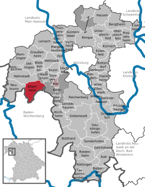
| Location of the community Altertheim in the district of Würzburg | ||
Altertheim is a municipality and a village in the Lower Franconian district of Würzburg and a member of the Kist administrative community .
geography
Geographical location
The place is located around 16 kilometers southwest of Würzburg and borders the Main-Tauber district in Baden-Württemberg . About five kilometers away, there is a connection to the motorways 3 and 81 via the state road 2297 which crosses the town .
The area belongs to the natural space unit Marktheidenfelder Platte as part of the Mainfränkische Platte . The places are in the Altbachtal. This is also where the Altbach has its source.
Community structure
There are three parts of the municipality (2007 population in brackets):
- Oberaltertheim with approx. 1200 citizens. (1226)
- Steinbach with about 120 citizens. (127)
- Unteraltertheim with approx. 835 citizens. (854)
There are also the Aussiedlerhöfe Niederhofen (district Ober- and Unteraltertheim), Karlebach (district Unteraltertheim) and Quelläcker (district Steinbach).
Surname
etymology
The name Altertheim consists of the female personal name Albtrud and the Old High German word heim .
Earlier spellings
Earlier spellings of the place from various historical maps and documents:
|
|
history
Until the founding of the forerunner churches
Ober- and Unteraltertheim were first mentioned in a document from the year 775. Today's municipality was formerly part of the Grafschaft Castell, which was part of the Franconian Empire from 1500 . In 1806 Unter- and Oberaltertheim were mediatized in favor of Bavaria. The places were left in 1810 (border purification) to the Grand Duchy of Würzburg of Archduke Ferdinand of Tuscany, with whom they finally fell to Bavaria in 1814 . In the course of the administrative reforms in Bavaria, the municipalities came into being with the municipal edict of 1818 .
19th and 20th centuries
A fire broke out on June 28, 1825, in which a large part of Oberaltertheim was a victim of the flames.
On May 1, 1978, the previously independent municipalities of Oberaltertheim, Steinbach bei Würzburg and Unteraltertheim were merged to form the new municipality of Altertheim as part of the municipal reform. In 1997 there were minor changes in the border towards the Baden-Württemberg community of Werbach .
On June 27, 1978 a helicopter of the US armed forces crashed in Unteraltertheim. The nine inmates died.
Religions
The community is predominantly evangelical-Lutheran . The mission company Liebenzeller Mission has also established itself. The members of the Roman Catholic Church belong to the parish of Helmstadt .
Population development
- 1840: 1371 inhabitants
- 1961: 1602 inhabitants
- 1970: 1695 inhabitants
- 1987: 1775 inhabitants
- 1991: 1911 inhabitants
- 1995: 2074 inhabitants
- 2000: 2094 inhabitants
- 2005: 2144 inhabitants
- 2010: 2068 inhabitants
- 2015: 1945 inhabitants
politics
- UBV : 9
- SPD : 3
Municipal council
In the local elections on March 15, 2020, of the 1,646 residents in the municipality of Altertheim who are entitled to vote, 1,189 exercised their right to vote, bringing the turnout to 72.24%.
mayor
- 1984–2008: Alfred Hemrich (Independent Citizens Association)
- 2008–2020: Adolf Hemrich-Manderbach (future Altertheim)
- 2020– : Bernd Korbmann (SPD)
In the local election on March 15, 2020, Bernd Korbmann was elected with 53.21% of the vote.
tax income
The municipal tax revenue amounted to around 986,000 euros in 2014, of which 95,000 were trade tax revenue (net). The debt level per inhabitant was 765 euros and thus 236 euros higher than in 2006.
coat of arms
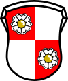
| Blazon : “Square of red and silver; in 1 and 4 a silver heraldic rose with golden studs. " | |
| Founding of the coat of arms: The municipalities of Oberaltertheim, Steinbach bei Würzburg and Unteraltertheim, which have merged in the new municipality of Altertheim, once belonged to the domain of the Counts of Wertheim; after their extinction (1556), this area passed to the Count's House of Castell. Castell's coat of arms shows the so-called crossing of red and silver; the silver heraldic rose is the badge of the Counts of Wertheim. In the present form, the union of these two symbols has served as the coat of arms of the municipality of Oberaltertheim since 1967. The newly formed Altertheim community has adopted this coat of arms in its unchanged form. |
Alliance Waldsassengau
Since November 20, 2014 Altertheim has been organized together with twelve other communities in the Alliance Waldsassengau . The association serves the intercommunal cooperation.
Culture and sights
Regular festivals
- Parish fair in Oberaltertheim, Unteraltertheim and Steinbach
- Carnival events in the respective districts
- Strackerfest
- The tractor festival every two years
- Festival under the linden trees
- Mountain Festival
- Grand meetings of the ACC
- Well festival
- Festivals on May 1st in the respective towns
- Motorcycle meeting of the motorcycle friends Oberaltertheim
- Fire brigade festival every ten years
- Singers' wreath festival every five years
synagogue
In the Oberaltertheim district there was a synagogue until the Nazi dictatorship , the facility of which was demolished during the November pogrom in 1938 . The small Jewish community existed until 1942, when the remaining Jewish families were deported for extermination in the Shoah . At the fire station in the Zaunlücke 2 a memorial plaque reminds of the church and its extinct community.
In the Unteraltertheim district there is still a synagogue on Brunnenstrasse. However, this is used as a warehouse for a local painting and plastering company.
Architectural monuments
traffic
The municipal area is crossed by the state road St 2297 .
Economy and Infrastructure
economy
In 2014 there were no employees at work in agriculture and forestry, 31 in manufacturing and no employees in trade and transport. In other economic sectors this value was 28 people. There were 869 employees at the place of residence subject to social security contributions. There were no companies in the manufacturing industry (as well as mining and quarrying of stones and earth) and in the main construction trade.
In agriculture, the number of farms fell significantly, following the general trend. In 2010 there were 36 farms (1999: 68) with a total of 1465 hectares used for agriculture. Of this, 1351 hectares were arable land and 85 hectares were permanent green space.
Biking and hiking trails
The Welzbachtalradweg connects Oberaltertheim after about twelve kilometers in a south-westerly direction with the Taubertalradweg near Werbach. In a north-easterly direction, cycle paths lead via Waldbrunn, Eisingen and Höchberg to the Main cycle path near Würzburg.
education
The following institutions existed in 2015:
- In two kindergartens, the Evangelical Kindergarten Oberaltertheim and the community kindergarten Unteraltertheim, with a total of 100 kindergarten places, 74 children are cared for and supported.
- There is a primary school in Oberaltertheim (the Arthur-Knorr-Schule in Kirchgasse 2)
Born in the church
- Gertrud Rückert (* 1917 in Oberaltertheim; † 2011 in Munich), founder and inventor of the Philadelphian Year (now a voluntary social year)
Web links
- Homepage
- Entry on the Altertheim coat of arms in the database of the House of Bavarian History
- Altertheim: Official statistics of the LfStat (PDF; 1.05 MB)
Individual evidence
- ↑ "Data 2" sheet, Statistical Report A1200C 202041 Population of the municipalities, districts and administrative districts 1st quarter 2020 (population based on the 2011 census) ( help ).
- ↑ a b https://okvote.osrz-akdb.de/OK.VOTE_UF/Wahl-2020-03-15/09679165/html5/Buergermeisterwahl_Bayern_108_Gemeinde_Gemeinde_Altertheim.html
- ^ Altertheim community in the local database of the Bayerische Landesbibliothek Online . Bavarian State Library
- ^ Altertheim community: districts. Oberaltertheim. 2020, accessed on May 24, 2020 : "About 1,200 citizens live in Oberaltertheim."
- ^ Altertheim community: districts. Steinbach. 2020, accessed on May 24, 2020 : "Around 120 citizens live in Steinbach."
- ^ Altertheim community: districts. Unteraltertheim. 2020, accessed on May 24, 2020 : "About 835 people live in Unteraltertheim."
- ↑ a b Wolf-Armin von Reitzenstein : Lexicon of Franconian place names. Origin and meaning . Upper Franconia, Middle Franconia, Lower Franconia. CH Beck, Munich 2009, ISBN 978-3-406-59131-0 , p. 23 ( limited preview in Google Book search).
- ^ Federal Statistical Office (ed.): Historical municipality directory for the Federal Republic of Germany. Name, border and key number changes in municipalities, counties and administrative districts from May 27, 1970 to December 31, 1982 . W. Kohlhammer GmbH, Stuttgart / Mainz 1983, ISBN 3-17-003263-1 , p. 756 .
- ↑ http://www.armyaircrews.com/huey.html
- ↑ a b c d e Altertheim: Official statistics of the LfStat
- ↑ a b https://okvote.osrz-akdb.de/OK.VOTE_UF/Wahl-2020-03-15/09679165/html5/Gemeinderatswahl_Bayern_110_Gemeinde_Gemeinde_Altertheim.html
- ^ Entry on the Altertheim coat of arms in the database of the House of Bavarian History , accessed on September 7, 2017 .
- ^ Alliance Waldsassengau in the west of Würzburg. Society. (No longer available online.) Archived from the original on January 29, 2016 ; accessed on January 20, 2016 .
- ↑ Memorial sites for the victims of National Socialism. A documentation, volume 1. Federal Agency for Civic Education, Bonn 1995, ISBN 3-89331-208-0 , p. 112
- ↑ Inlinemap.net: Welzbachtalradweg . Online at www.inlinemap.net. Retrieved May 30, 2017
- ^ Website of the municipality
- ↑ www.stayfriends.de: Arthur-Knorr-Schule
- ↑ Heidrun Groth: German school addresses: Bavaria. ( Google Books )


