
Zellingen
| coat of arms | Germany map | |
|---|---|---|

|
Coordinates: 49 ° 54 ' N , 9 ° 49' E |
|
| Basic data | ||
| State : | Bavaria | |
| Administrative region : | Lower Franconia | |
| County : | Main-Spessart | |
| Management Community : | Zellingen | |
| Height : | 169 m above sea level NHN | |
| Area : | 41.44 km 2 | |
| Residents: | 6373 (Dec. 31, 2019) | |
| Population density : | 154 inhabitants per km 2 | |
| Postal code : | 97225 | |
| Primaries : | 09364, 09396 | |
| License plate : | MSP | |
| Community key : | 09 6 77 203 | |
| LOCODE : | DE ZEN | |
| Market structure: | 3 districts | |
Market administration address : |
Würzburger Strasse 26 97225 Zellingen |
|
| Website : | ||
| Mayor : | Stefan Wohlfahrt ( CSU ) | |
| Location of the Zellingen market in the Main-Spessart district | ||
  |
||

Zellingen is a market in the Lower Franconian district of Main-Spessart and the seat of the Zellingen administrative community .
geography
Zellingen is located in the Würzburg am Main region . The Franconian Marienweg runs through Zellingen .
Community structure
Zellingen is divided into three districts:
There are the districts Duttenbrunn, Retzbach and Zellingen.

Surname
etymology
The name Zellingen is based on the personal name Cello or Zello , which was derived from the Old High German suffix -ing .
Earlier spellings
Earlier spellings of the place from various historical maps and documents:
|
|
history

Until the church is planted
In the years 1312 and 1313, the Schweinfurt town charter applied temporarily in Zellingen, which, however, remained unused. As a former office of the Hochstift Würzburg , which belonged to the Franconian Empire , Zellingen fell to Bavaria during the secularization of 1803, was given to Archduke Ferdinand of Tuscany in 1805 ( Peace of Preßburg ) to form the Grand Duchy of Würzburg and with this in 1814 it finally came to Bavaria. In the course of the administrative reforms in Bavaria, today's municipality was created with the municipal edict of 1818 .
religion
The following churches are located in Zellingen:
- the parish church of St. Georg, formerly a castle of the Prince-Bishop of Greiffenclau
- the Maria-Hilf-Chapel with candlesticks of the Scapular Brotherhood Zellingen
- the corridor chapel Sankt Therese on the Kirchberg
Incorporations
On January 1, 1975, the Retzbach market was incorporated. Duttenbrunn was added on May 1, 1978.
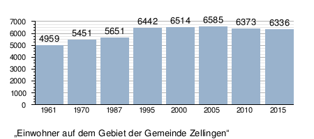
Population development
In the period from 1988 to 2018, the population increased from 5,679 to 6,377 by 698 inhabitants or by 12.3%.
politics
mayor

Wieland Gsell won the runoff election on March 16, 2008 with 51.51% of the votes against the incumbent Karl Mühlbauer (CSU) as candidate for mayor of the Greens. In 2014, Wieland Gsell won with an absolute majority (58.66%) in the first ballot. Competitors were Philipp Kromczynski (CSU) and Andrea Heßdörfer ( Free Citizens ). The turnout was 67.26%.
In the election on March 15, 2020, Stefan Wohlfart (CSU) prevailed with 54.5% of the vote. The turnout was 67.3%.
Municipal council
The local elections in 2002, 2008 , 2014 and 2020 led to the following allocation of seats in the local council:
| Party / electoral alliance | 2002 | 2008 | 2014 | 2020 |
|---|---|---|---|---|
| CSU | 9 | 8th | 7th | 8th |
| Green | n / A | 2 | 5 | 3 |
| SPD | 6th | 4th | 3 | 4th |
| Free citizens | 2 | 4th | 3 | 3 |
| Civic Association Duttenbrunn | 1 | 2 | 2 | 2 |
| Greens / ÖDP | 2 | n / A | n / A | - |
| total | 20th | 20th | 20th | 20th |
coat of arms

The old coat of arms showed St. George on horse killing a dragon. The patron saints of Zellingens are Saint George and Saint Sebastian. The two kindergartens are named after them. The coat of arms was officially valid until the incorporation of Retzbach in 1975. The new coat of arms has been official since 1982.
Community partnerships
Zellingen has partnerships with Geyer in Saxony (since 1990), with the French community of Louvigny (since 1984) and Tiefenbach in Lower Bavaria (since 1974).
Architectural monuments
Economy and Infrastructure

Economy including agriculture and forestry
In 1998, according to official statistics, there were no employees subject to social security contributions in the manufacturing industry or in the trade and transport sector at the place of work. In other economic sectors, 358 people were employed at the place of work subject to social security contributions. There were a total of 2199 employees at the place of residence subject to social security contributions. There were none in the manufacturing sector and four in the construction sector. In addition, in 1999 there were 111 farms with an agricultural area of 1212 hectares, of which 1102 hectares were arable land and 52 hectares were permanent green space.
traffic
Zellingen is connected to the neighboring towns and to Würzburg by several bus routes. The Retzbach-Zellingen train station is on the eastern side of the Main on the Würzburg – Gemünden line . The railway - Hanover-Würzburg high-speed railway crosses the area of the market town, with the Hohewart tunnel and Bartels grave Viaduct . The Main is spanned by the Alte Mainbrücke Zellingen , which was first built in 1884, blown up on March 27, 1945 and rebuilt after the Second World War , and a new Main Bridge from 1993.
education
There are the following institutions (as of 2015):
- 325 places in day-care centers with 264 children
- two elementary schools with 18 teachers and 268 students
Personalities
- Ludwig Hagenauer (1883–1949), lawyer and politician born in Retzbach
- Karl Staab (1892–1974), Roman Catholic clergyman and biblical scholar at the University of Würzburg
Web links
- Entry on the coat of arms of Zellingen in the database of the House of Bavarian History
Individual evidence
- ↑ "Data 2" sheet, Statistical Report A1200C 202041 Population of the municipalities, districts and administrative districts 1st quarter 2020 (population based on the 2011 census) ( help ).
- ↑ http://www.bayerische-landesbibliothek-online.de/orte/ortssuche_action.html ? Anzeige=voll&modus=automat&tempus=+20111119/232109&attr=OBJ&val= 1750
- ↑ a b Wolf-Armin von Reitzenstein : Lexicon of Franconian place names. Origin and meaning . Upper Franconia, Middle Franconia, Lower Franconia. CH Beck, Munich 2009, ISBN 978-3-406-59131-0 , p. 253 ( limited preview in Google Book search).
- ^ Federal Statistical Office (ed.): Historical municipality directory for the Federal Republic of Germany. Name, border and key number changes in municipalities, counties and administrative districts from May 27, 1970 to December 31, 1982 . W. Kohlhammer, Stuttgart / Mainz 1983, ISBN 3-17-003263-1 , p. 762 and 763 .
- ↑ http://www.mainpost.de/lokales/mainspessart/Die-Wahl-in-Karlstadt;art25009,4398455
- ^ Result of the BGM election in Zellingen 2014 on March 16, 2014. Markt Zellingen. Administrative community Zellingen , March 21, 2014, accessed on April 3, 2014 .
- ^ Result of the GR-Zellingen 2014 on March 16, 2014. Markt Zellingen. Administrative community Zellingen , March 16, 2014, accessed on April 3, 2014 .
- ↑ Preliminary result of the municipal council election on March 15th, 2020. The election officer of the community 677203 Markt Zellingen, accessed on March 24, 2020 .

Arnstein | Aura in the reason | Birkenfeld | Bischbrunn | Burgsinn | Erlenbach near Marktheidenfeld | Esselbach | Eußenheim | Skins | Frammersbach | Gemünden am Main | Gössenheim | Graefendorf | Hafenlohr | Hasloch | Sky city | Karbach | Karlstadt | Karsbach | Kreuzwertheim | Lohr am Main | Marktheidenfeld | Middle sense | Neuendorf | Neuhütten | Neustadt am Main | Obersinn | Partenstein | Rechtenbach | Retzstadt | Rieneck | Clearing | Rothenfels | Schollbrunn | Steinfeld | Thüngen | Triefenstein | Urspringen | Wiesthal | Zellingen
Municipality-free areas in the district of Main-Spessart
Burgjoss |
Forest aura |
Forest Lohrerstraße |
Frammersbach Forest |
Princely Löwensteinscher Park |
Haurain |
Herrnwald |
Langenprozeltener forest |
Partenstein Forest |
Ruppertshütten forest