Retzstadt
| coat of arms | Germany map | |
|---|---|---|

|
Coordinates: 49 ° 55 ' N , 9 ° 53' E |
|
| Basic data | ||
| State : | Bavaria | |
| Administrative region : | Lower Franconia | |
| County : | Main-Spessart | |
| Management Community : | Zellingen | |
| Height : | 240 m above sea level NHN | |
| Area : | 18.08 km 2 | |
| Residents: | 1565 (Dec. 31, 2019) | |
| Population density : | 87 inhabitants per km 2 | |
| Postal code : | 97282 | |
| Area code : | 09364 | |
| License plate : | MSP | |
| Community key : | 09 6 77 175 | |
| LOCODE : | DE RYZ | |
| Community structure: | 1 district | |
| Association administration address: | Würzburger Str. 26 97225 Zellingen |
|
| Website : | ||
| Mayor : | Karl Gerhard ( CSU ) | |
| Location of the municipality of Retzstadt in the Main-Spessart district | ||
Retzstadt is a municipality in the Lower Franconian district of Main-Spessart and a member of the Zellingen administrative community .
geography
Retzstadt is located in the Main-Spessart district in a side valley of the Main on the Retz.
Retzstadt has only one district. There is only the district of Retzstadt.
Surname
etymology
The name Retzstadt is derived from the Retz brook which flows into the Main in Retzbach .
Earlier spellings
Earlier spellings of the place from various historical maps and documents:
|
|
history
"Reccisstadt" was first mentioned in a document in the middle of the 8th century. Retzstadt was secularized in 1803 in favor of Bavaria as part of the Bishopric Würzburg (cathedral chapter), which belonged to the Franconian Empire , then left in the Peace of Pressburg to Archduke Ferdinand of Tuscany to form the Grand Duchy of Würzburg, with which it finally fell to Bavaria in 1814. In the course of the administrative reforms in Bavaria, today's municipality was created with the municipal edict of 1818 .
Population development
In the period from 1988 to 2018, the population stagnated; in concrete terms, it rose minimally from 1553 to 1555 by 2 residents or 0.1%.
Architectural monuments
- Parish church, built according to plans by Balthasar Neumann
politics
mayor
Karl Gerhard (CSU) has been mayor since May 1, 2008; he was elected for a further six years on March 15, 2020 with 92.3% of the vote. Its predecessors were:
- Siegfried Schmitt (Christian Free Voters) from 2002 to 2008
- Reinhold H. Möller (CSU / Independent Voting Group) from 1984 to 2002
Municipal council
Distribution of seats after the 2020 election:
- CSU : 7 seats
- Christian Free Voters : 5 seats
Compared to 2014, the CSU won four additional mandates; these seats had previously been held by the UWG, which had not taken up any more.
Community partnerships
Retzstadt maintains partnerships with the French municipalities of Mouen and Mondrainville (since 1990).
coat of arms
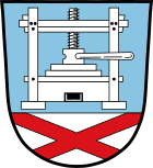
Blazon : Over a silver shield base, inside a red St. Andrew's cross, in blue a silver wine press.
Economy including agriculture and forestry
According to official statistics, there were 22 employees at the place of work in the manufacturing sector and seven in the trade and transport sector. In other economic areas, 18 people were employed at the place of work subject to social security contributions. There were a total of 600 employees at the place of residence subject to social security contributions. There were ten companies in the manufacturing sector and no companies in the main construction sector. In 1999 there were 71 farms with an agricultural area of 1378 ha, of which 1172 ha were arable land and 142 ha were permanent green space. Wine is grown on an area of more than 80 hectares. In 2000, Retzstadt was one of the 19 external Bavarian projects at EXPO 2000 as "Teledorf Retzstadt". Retzstadt was a model location for the use of information and communication technology for the development of rural areas.
Educational institutions
There are the following institutions (as of 2015):
- Day care center: 67 places with 54 children
- Elementary school with five teachers and 50 students
- catholic public library
Personalities
- Kilian Kaspar Flasch (1831–1891), Bishop of La Crosse (Wisconsin) , USA
- Vinzenz Koch (1834–1881), Catholic clergyman, member of the Bavarian House of Representatives
Web links
- Website of the municipality of Retzstadt
- Information on the parish church of St. Andreas
- Entry on the coat of arms of Retzstadt in the database of the House of Bavarian History
Individual evidence
- ↑ "Data 2" sheet, Statistical Report A1200C 202041 Population of the municipalities, districts and administrative districts 1st quarter 2020 (population based on the 2011 census) ( help ).
- ↑ http://www.bayerische-landesbibliothek-online.de/orte/ortssuche_action.html ? Anzeige=voll&modus=automat&tempus=+20111119/221551&attr=OBJ&val= 1741
- ↑ a b Wolf-Armin von Reitzenstein : Lexicon of Franconian place names. Origin and meaning . Upper Franconia, Middle Franconia, Lower Franconia. CH Beck, Munich 2009, ISBN 978-3-406-59131-0 , p. 187 ( limited preview in Google Book search).
- ↑ http://www.retzstadt.de/eigene_daten/vgem-zellingen/rathaus-verwaltung/pdf-sonstige/rgem._knownmachung_vorl._result.pdf Election result municipal council 2020


