Eussenheim
| coat of arms | Germany map | |
|---|---|---|

|
Coordinates: 49 ° 59 ' N , 9 ° 49' E |
|
| Basic data | ||
| State : | Bavaria | |
| Administrative region : | Lower Franconia | |
| County : | Main-Spessart | |
| Height : | 194 m above sea level NHN | |
| Area : | 56.81 km 2 | |
| Residents: | 3103 (Dec. 31, 2019) | |
| Population density : | 55 inhabitants per km 2 | |
| Postal code : | 97776 | |
| Primaries : | 09350, 09353 | |
| License plate : | MSP | |
| Community key : | 09 6 77 127 | |
| Community structure: | 7 parts of the community | |
| Address of the municipal administration: |
Am Kirchberg 16 97776 Eußenheim |
|
| Website : | ||
| Mayor : | Achim Höfling (Free Voters) | |
| Location of the community of Eußenheim in the Main-Spessart district | ||
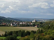
Eußenheim is a municipality in the Lower Franconian district of Main-Spessart .
geography
Geographical location
The place Eußenheim is on the Wern , in the Würzburg region, Main-Spessart district, in the "Franconian wine country".
Community structure
The municipality has seven officially named municipality parts :
There are the districts of Aschfeld, Bühler, Eußenheim, Hundsbach, Münster and Obersfeld.
Surname
etymology
The name Eußenheim consists of the personal name Uzzo and the Old High German word heim .
Earlier spellings
Earlier spellings of the place from various historical maps and documents:
|
|
history
Until the church is planted
In the 3rd and 4th centuries, the Germanic tribes of the Alemanni and Thuringians inhabited the area around today's Eußenheim. They were finally defeated by the Franks, who later advanced from the Rhine and Moselle regions to the central mainland. They also took the valley of the river Wern. In 531 the Franks had incorporated the Thuringian Empire and thus also this area into their state. Then the first Franconian settlement wave began. The Franks moved into the country in closed associations, the leaders at the head. The name of their 531–550 settlements on the rivers and streams is made up of the personal names of these leaders and the ending "home". This is how the name "Uzzo-Heim" (Eußenheim) came about, which was first settled and mentioned in a document in the 6th century.
The noble family von Heusslein lived here from the 12th and 16th centuries. The parish church of St. Marcellinus and St. Petrus, located high above the village, was built in 1619. The former cellar of the Würzburg cathedral chapter of the Würzburg bishopric was left to Archduke Ferdinand of Tuscany to form the Grand Duchy of Würzburg after the secularization in 1803 in favor of Bavaria in 1805 and finally fell to Bavaria in 1814 . In the course of the administrative reforms in Bavaria, today's municipality was created with the municipal edict of 1818 . see also Schönart's castle ruins
Religions
There are only catholic houses of worship in the area of the community of Eußenheim. With the exception of the St. Ottilie Church in Schönarts, which is a branch of the Stetten parish , all parishes belong to the Bachgrund parish community in the Karlstadt dean's office of the Würzburg diocese . These are the parishes of St. Bonifatius Aschfeld, St. Nikolaus Bühler with a branch of St. Martin in Munster , St. Marcellinus and Petrus Eußenheim and St. Andreas Hundsbach with a branch of St. Peter and Paul in Obersfeld.
Incorporations
On May 1, 1978, Eußenheim merged with the basic Bach communities of Aschfeld, Bühler, Hundsbach, Münster and Obersfeld to form a community of Eußenheim.
Population development
In the period from 1988 to 2018, the population decreased from 3,203 to 3,110 by 93 inhabitants or 2.9%.
- 1961: 3267 inhabitants
- 1970: 3400 inhabitants
- 1987: 3191 inhabitants
- 1991: 3360 inhabitants
- 1995: 3407 inhabitants
- 2000: 3374 inhabitants
- 2005: 3407 inhabitants
- 2010: 3249 inhabitants
- 2015: 3194 inhabitants
politics
Achim Höfling has been Mayor of Free Voters since May 1, 2020 . He was elected on March 15, 2020 with 51.8% of the vote. Its predecessors were:
- Dieter Schneider (CSU) from May 1, 2008 to April 30, 2020
- Herbert Schneider (CSU) until April 30, 2008.
coat of arms
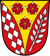
| Blazon : “In red a fallen, curly golden tip, inside three two red heraldic roses with golden lugs and silver sepals; in front a doubled silver diamond sloping bar, in the back a silver ash branch slanted to the left. " | |
Attractions
- Parish Church of St. Marcellinus and St. Peter
- Fortified church St. Bonifatius in Aschfeld, built around 1500 ( picture )
- Wayside shrine trail ( picture )
- the nearby Homburg Castle , one of the largest castle ruins in Germany
- The Kühles Loch natural monument in Münster, one of the richest springs in Lower Franconia
- The Grainberg-Kalbenstein and Saupurzel nature reserve
Architectural monuments
Economy and Infrastructure
Economy including agriculture and forestry
After the decline of viticulture in the 19th century, there was an upswing again after the land consolidation in 1972 (vineyard Eußenheimer First).
In 1998, according to official statistics, there were no employees subject to social security contributions in the manufacturing industry and in the trade and transport sector. In other economic areas, 50 people were employed at the place of work subject to social security contributions. There were a total of 1268 employees at the place of residence subject to social security contributions. There was one company in the manufacturing sector and three companies in the main construction sector. In addition, in 1999 there were 98 farms with an agriculturally used area of 2869 hectares, of which 2633 hectares were arable land and 205 hectares were permanent green space.
traffic
In the Schönarts district there is a Deutsche Bahn AG switchgear that connects the single-circuit 110-kV traction power line to Waigolshausen to the two-circuit traction power line Würzburg-Gemünden. Although this system is located directly on the electrified Werntalbahn , there is no feed into the overhead line, which is why this system is not a substation .
education
There are the following institutions (as of 2018):
- Three day-care centers with a total of 161 places and 114 children
- Primary school and middle school with a total of 12 full-time teachers and 172 pupils (school year 2018/2019)
Web links
Individual evidence
- ↑ "Data 2" sheet, Statistical Report A1200C 202041 Population of the municipalities, districts and administrative districts 1st quarter 2020 (population based on the 2011 census) ( help ).
- ↑ Municipal Council. Community of Eußenheim, accessed on June 28, 2020 .
- ^ Community of Eußenheim in the local database of the Bavarian State Library Online . Bayerische Staatsbibliothek, accessed on March 5, 2018.
- ↑ a b Wolf-Armin von Reitzenstein : Lexicon of Franconian place names. Origin and meaning . Upper Franconia, Middle Franconia, Lower Franconia. CH Beck, Munich 2009, ISBN 978-3-406-59131-0 , p. 68 ( limited preview in Google Book search).
- ↑ a b c Federal Statistical Office (ed.): Historical municipality directory for the Federal Republic of Germany. Name, border and key number changes in municipalities, counties and administrative districts from May 27, 1970 to December 31, 1982 . W. Kohlhammer GmbH, Stuttgart / Mainz 1983, ISBN 3-17-003263-1 , p. 763 .
- ↑ Entry on the coat of arms of Eußenheim in the database of the House of Bavarian History
- ↑ Primary school Eußenheim in the school database of the Bavarian State Ministry for Education and Culture , accessed on August 31, 2019 (5 teachers, 110 students)
- ↑ Middle School Eußenheim in the school database of the Bavarian State Ministry for Education and Culture , accessed on August 31, 2019 (7 teachers, 62 students)


