
Gusborn
| coat of arms | Germany map | |
|---|---|---|

|
Coordinates: 53 ° 5 ' N , 11 ° 13' E |
|
| Basic data | ||
| State : | Lower Saxony | |
| County : | Lüchow-Dannenberg | |
| Joint municipality : | Elbe Valley | |
| Height : | 17 m above sea level NHN | |
| Area : | 48.27 km 2 | |
| Residents: | 1196 (Dec. 31, 2019) | |
| Population density : | 25 inhabitants per km 2 | |
| Postal code : | 29476 | |
| Area code : | 05865 | |
| License plate : | DAN | |
| Community key : | 03 3 54 008 | |
| Community structure: | 6 districts | |
| Address of the municipal administration: |
Dorfstrasse 36 29476 Gusborn |
|
| Mayor : | Uwe Beckmann ( UG ) | |
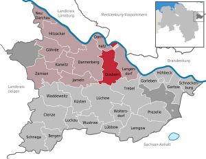
| Location of the community of Gusborn in the Lüchow-Dannenberg district | ||
  |
||

Gusborn is a municipality in the Lüchow-Dannenberg district in Lower Saxony and part of the Elbtalaue municipality .
geography
Geographical location
Gusborn is bounded in the northern part by the Elbe ; otherwise the community extends over the western part of the Langendorfer Geestinsel and adjacent areas of the Elbaue and the Lüchower low terrace.
Community structure
The municipality of Gusborn has consisted of six districts since the municipal reform of 1972. In addition, there are the Forsthaus Seybruch and Hof Wulfsahl residential areas, which, like the village of Sipnitz , belonged to the then Quickborn community before 1972.
- Groß Gusborn (approx. 340 inhabitants)
- Klein Gusborn (approx. 350 inhabitants)
- Quickborn (approx. 400 inhabitants)
- Siemen (approx. 120 inhabitants)
- Sipnitz (approx. 20 inhabitants)
- Zadrau (approx. 120 inhabitants)
- Forsthaus Seybruch
- Wulfsahl farm
The seat of the municipal administration is in Quickborn.
history
On July 1, 1972, the community of Gusborn was re-formed through the merger of the previous communities of Groß Gusborn, Klein Gusborn, Quickborn, Siemen and Zadrau. Klein Gusborn had more inhabitants than Groß Gusborn. The Quickborn community brought in most of the residents. The two districts of Groß Gusborn and Klein Gusborn have now grown together through the new housing estate Durlei to form a local area in which more than half of the community's population lives.
politics
The community of Gusborn belongs to the state electoral district 48 Elbe and to the federal electoral district 38 Lüchow-Dannenberg - Lüneburg .
Municipal council
The Gusborn municipal council has 11 members, who have been divided into four electoral associations since the 2016 local elections.
- Future Gusborn - 5 seats
- Independent Gusborner - 4 seats
- Alliance 90 / The Greens - 1 seat
- Solos - 1 seat
mayor
Mayor of the community of Gusborn is Hartmut Ringel from the future of Gusborn (elected on November 24, 2016).
Culture and sights

The list of monuments in Gusborn contains all the monuments of the municipality of Gusborn.
Economy and Infrastructure
Doctors and veterinarians
There are several veterinarians in the community.
traffic
The federal road 191 runs through the community in the Dannenberg (Elbe) - Dömitz section , which runs north of the Quickborn district. The villages of Groß Gusborn and Klein Gusborn are accessed via the L256 state road (Dannenberg– Gartow ).
education
In Gusborn there is a primary school in Groß Gusborn and a play area in Siemen.
Buildings
In the vicinity of Gusborn there is a 97 meter high steel lattice tower called the Torii Tower , which was used as a listening post until the early 1990s .
Others
Every 5 years there is a village week in the community of Gusborn, in which all districts take part with a wide variety of events. Once a year, always on the first Friday in August, the "Wiesenfete" takes place in the Quickborn district.
Individual evidence
- ↑ State Office for Statistics Lower Saxony, LSN-Online regional database, Table 12411: Update of the population, as of December 31, 2019 ( help ).
- ^ Federal Statistical Office (ed.): Historical municipality directory for the Federal Republic of Germany. Name, border and key number changes in municipalities, counties and administrative districts from May 27, 1970 to December 31, 1982 . W. Kohlhammer GmbH, Stuttgart / Mainz 1983, ISBN 3-17-003263-1 , p. 231 .
- ↑ Landtag constituencies from the 16th electoral term. Constituency division for the election to the Lower Saxony state parliament. Annex to § 10 para. 1 NLWG, p. 4. ( PDF ( Memento of the original from July 25, 2011 in the Internet Archive ) Info: The archive link has been inserted automatically and has not yet been checked. Please check the original and archive link according to the instructions and remove then this note .; 87 kB)
- ↑ Description of the constituencies. Annex to Section 2, Paragraph 2 of the Federal Election Act. In: Eighteenth law amending the federal electoral law. Annex to Article 1. Bonn, March 18, 2008, p. 325. ( PDF ( Memento of the original from July 25, 2011 in the Internet Archive ) Info: The archive link has been inserted automatically and has not yet been checked. Please check the original and archive link according to the instructions and then remove this note .; 200 kB)
Web links
Bergen on the stupid | Clenze | Damnatz | Dannenberg (Elbe) | Gartow | Goehrde | Gorleben | Gusborn | Hitzacker (Elbe) | Höhbeck | Jameln | Karwitz | Coasts | Langendorf | Lemgow | Lübbow | Lüchow (Wendland) | Luckau (Wendland) | New Darchau | Precell | Schnackenburg | Schnega | Trebel | Waddeweitz | Woltersdorf | Wustrow (Wendland) | Ceremonies
Municipality-free areas in the Lüchow-Dannenberg
Gartow district |
Goehrde