
Lemgow
| coat of arms | Germany map | |
|---|---|---|

|
Coordinates: 52 ° 55 ' N , 11 ° 19' E |
|
| Basic data | ||
| State : | Lower Saxony | |
| County : | Lüchow-Dannenberg | |
| Joint municipality : | Lüchow (Wendland) | |
| Height : | 29 m above sea level NHN | |
| Area : | 64.47 km 2 | |
| Residents: | 1356 (Dec. 31, 2019) | |
| Population density : | 21 inhabitants per km 2 | |
| Postal code : | 29485 | |
| Area code : | 05883 | |
| License plate : | DAN | |
| Community key : | 03 3 54 015 | |
| Community structure: | 12 districts | |
| Association administration address: | Theodor-Körner-Strasse 14 29439 Lüchow (Wendland) |
|
| Mayor : | Horst Kaufmann ( CDU ) | |
| Location of the municipality Lemgow in the Lüchow-Dannenberg district | ||
  |
||

Lemgow is a municipality in the Lüchow-Dannenberg district in Lower Saxony .
geography
Geographical location
The community is located in the southern Wendland on the Lemgow, a ground moraine plateau formed in the Saale Ice Age , which today towers over the surrounding lowlands as a plateau . The municipality belongs to the joint municipality Lüchow (Wendland) , which has its administrative seat in the city of Lüchow (Wendland) .
Community structure
The municipality of Lemgow consists of the following districts:
- Buck life
- Gross joke nets , until March 16, 1936 Joke nets in Lemgow
- Kriwitz
- Predöhl
- Prezier
- Putt ball
- Schletau
- Schmarsau
- Schweskau
- Simander
- Trabuhn
- Volzendorf
The districts of Schweskau and Puttball have now grown together to form a single location.
history
Religions
In the community there is the Evangelical Lutheran parish Lemgow with the parish seat in Schweskau.
Incorporations
On July 1, 1972, the communities of Bockleben, Großwitzeetze, Kriwitz, Predöhl, Prezier, Puttball, Schletau, Schmarsau, Schweskau, Simander, Trabuhn and Volzendorf were incorporated into the newly formed Lemgow community.
politics
The municipality of Lemgow belongs to the state electoral district 48 Elbe and to the federal electoral district 38 Lüchow-Dannenberg - Lüneburg .
Municipal council
The Lemgow City Council is made up of eleven council women and councilors.
(Status: local election on September 11, 2016)
mayor
The honorary mayor Horst Kaufmann was elected for the fourth time on September 11, 2016.
coat of arms
The municipality's coat of arms is in two parts. Above it shows the High Church in Lemgow. Below you can see the church (cross) surrounded by the twelve villages (lines).
Buildings

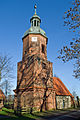
The high church is the symbol of the community. It is dedicated to John the Baptist . Its brick tower is probably from the 15th century, the apse made of field stones from the 14th century; the central part of the church was renewed around 1770. All components follow different styles. The tower and apse are Gothic , the central part has had baroque features since its renovation . The organ inside dates from 1856 and was created by Eduard Meyer (1806–1889), Hanover. The church is bordered by an approx. Two hectare cemetery with old trees and an avenue of lime trees.
Six other chapels in Bockleben, Prezier, Schmarsau, Schweskau, Simander and Volzendorf also belong to the parish .
The St. George Chapel in Bockleben was built from field stones in the Middle Ages. The altar is carved from a stone and painted with Christian motifs.
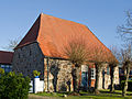
The Holy Three Kings Chapel in Prezier is a field stone building from the Middle Ages. The relatively large church tower from 1785 is striking.
The St. Jakobi Chapel in Schmarsau is a church built with field stones.
The St. Antonius Chapel in Schweskau is probably built during the Christianization of Lemgows. In 1895 a tower was added to the church. The chapel is the only one in Lemgow to have a pulpit.
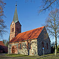
The St. Nicolai Chapel in Simander is a neo-Gothic brick building with a tower from 1865.
The St. Petri Chapel in Volzendorf dates from the 14th century. It is a field stone chapel with a neo-Gothic brick tower.

St. George's Chapel in Bockleben
Chapel of the Three Kings in Prezier
St. Jakobi Chapel in Schmarsau
St. Antonius Chapel in Schweskau

St. Nicholas Chapel in Simander

St. Petri Chapel in Volzendorf


Every village in the parish that does not have a chapel has a bell tower. The high church and the chapels are connected by a cycle path.
traffic
- The B 248 Salzwedel - Lüchow - Dannenberg (Elbe) runs about six kilometers west of the municipality.
- The B 493 Uelzen –Lüchow– Schnackenburg runs about six kilometers north of the municipality.
The area of today's municipality Lemgow opened up the railway line of the Lüchow-Schmarsauer Eisenbahn until 1969 . Today the company still operates bus route 8050 (formerly 1938), which connects the villages of Lemgow with Lüchow. The next train station with passenger traffic is now Salzwedel on the Stendal – Uelzen railway line , about 13 km southwest of Lemgow.
Personalities
- Ton Veerkamp (born November 19, 1933), theologian, lives in Lemgow
Web links
- Information about Lemgow on the Samtgemeinde website
- Lemgow near Predöhl, high church. Organ by Eduard Meyer (1856) on the website of NOMINE (= North German organ music culture in Lower Saxony and Europe)
Individual evidence
- ↑ State Office for Statistics Lower Saxony, LSN-Online regional database, Table 12411: Update of the population, as of December 31, 2019 ( help ).
- ↑ Statistics of the German Reich, Volume 450: Official municipality directory for the German Reich, Part I, Berlin 1939; Page 265
- ↑ Parish Lemgow on the website of the church district Lüchow-Dannenberg, accessed on November 25, 2012.
- ^ Federal Statistical Office (ed.): Historical municipality directory for the Federal Republic of Germany. Name, border and key number changes in municipalities, counties and administrative districts from May 27, 1970 to December 31, 1982 . W. Kohlhammer GmbH, Stuttgart / Mainz 1983, ISBN 3-17-003263-1 , p. 232 .
- ↑ Landtag constituencies from the 16th electoral term. Constituency division for the election to the Lower Saxony state parliament. Annex to § 10 para. 1 NLWG, p. 4. ( PDF ( Memento of the original from July 25, 2011 in the Internet Archive ) Info: The archive link has been inserted automatically and has not yet been checked. Please check the original and archive link according to the instructions and remove then this note .; 87 kB)
- ↑ Description of the constituencies. Annex to Section 2, Paragraph 2 of the Federal Election Act. In: Eighteenth law amending the federal electoral law. Annex to Article 1. Bonn, March 18, 2008, p. 325. ( PDF ( Memento of the original from July 25, 2011 in the Internet Archive ) Info: The archive link has been inserted automatically and has not yet been checked. Please check the original and archive link according to the instructions and then remove this note .; 200 kB)
- ^ Working group Lüneburg Heath of the Church Service in Leisure, Recreation and Tourism, Office for Community Service of the Evangelical Lutheran. Landeskirche (Hrsg.): Churches and monasteries in the Lüneburg Heath . 3. Eastern area, 1995.
- ↑ EYC: "New wall anchors for the tower" , accessed on 25 November 2012 found.
- ↑ Ernst-Günther Behn: The Hannoversche Wendland - churches and chapels. Page 154.
- ↑ EJZ: "Shining cross on white silk" , accessed on November 25, 2012.
- ↑ EYC "belfry with new bar" , accessed on 25 November 2012 found.
- ↑ EJZ: circular cycle path leads to chapels , accessed on November 25, 2012.
Bergen on the stupid | Clenze | Damnatz | Dannenberg (Elbe) | Gartow | Goehrde | Gorleben | Gusborn | Hitzacker (Elbe) | Höhbeck | Jameln | Karwitz | Coasts | Langendorf | Lemgow | Lübbow | Lüchow (Wendland) | Luckau (Wendland) | New Darchau | Precell | Schnackenburg | Schnega | Trebel | Waddeweitz | Woltersdorf | Wustrow (Wendland) | Ceremonies
Municipality-free areas in the Lüchow-Dannenberg
Gartow district |
Goehrde