Frammersbach Forest

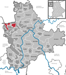
The Frammersbacher Forst is a 16.81 km² community-free area in the district of Main-Spessart in the Bavarian Spessart . The area is completely forested .
geography
location
The forest is located in the north on the Hessian border and consists of three separate areas. These are to the west, north and east of the eponymous capital . The highest point is the Eichenberg at 544 m above sea level. NN .
The eastern border of the western part forms the so-called "Wiesener Straße", a medieval trade route through the Spessart from the Kinzig valley to the Main . On this border section it coincides with the Schneewittchen-Wanderweg , a 35 km long route from Lohr am Main to Bieber , as well as the European cultural path "Frammersbach 1" of the Archaeological Spessart Project . Historical boundary stones mark the border between the Kurmainz state forest (after the Congress of Vienna in 1815 it became the state forest of the Kingdom of Bavaria) and the Frammersbach community forest. The boundary stones are marked with the Mainz wheel and the designation KW (Royal Forest).
Neighboring communities
|
Wiesener Forst (community-free area) |
community Flörsbachtal |
Haurain ( non- parish area) |

|
Ruppertshüttener Forst (community-free area) |
|
| Community Wiesthal |
Markt Frammersbach and Partensteiner Forst ( non- community area) |
Community Partenstein |
use
In the past, similar to Partenstein, attempts were made to mine heavy spar in the Frammersbach Forest . However, the yield was too low. Pingen , today filled with water, still document these attempts.
Not every water hole in the Frammersbach Forest is a pinge. In the "Aschenmaul" district, the depressions are former clay pits; the clay was used as a building material. You can distinguish these clay holes from the pings due to the lack of spoil heaps.
In the Middle Ages there were several glassworks in the Frammersbach Forest . Its glassmakers built the Holy Cross Chapel in the 14th century. The current building dates from 1681.
The Frammersbach Forest is now a hiking area.
See also
Web links
- Unregulated area of Frammersbacher Forst in OpenStreetMap (accessed on August 27, 2017)
European culture trail Frammersbach 1
Coordinates: 50 ° 4 ′ 49.8 " N , 9 ° 29 ′ 18.3" E
