
Kreuzwertheim
| coat of arms | Germany map | |
|---|---|---|

|
Coordinates: 49 ° 46 ' N , 9 ° 31' E |
|
| Basic data | ||
| State : | Bavaria | |
| Administrative region : | Lower Franconia | |
| County : | Main-Spessart | |
| Management Community : | Kreuzwertheim | |
| Height : | 144 m above sea level NHN | |
| Area : | 19.98 km 2 | |
| Residents: | 3952 (December 31, 2019) | |
| Population density : | 198 inhabitants per km 2 | |
| Postal code : | 97892 | |
| Area code : | 09342 | |
| License plate : | MSP | |
| Community key : | 09 6 77 151 | |
| LOCODE : | DE KWM | |
| Market structure: | 4 districts | |
Market administration address : |
Lengfurter Str. 8 97892 Kreuzwertheim |
|
| Website : | ||
| Mayor : | Klaus Thoma (non-party) | |
| Location of the Kreuzwertheim market in the Main-Spessart district | ||
  |
||

Kreuzwertheim is a market in the Lower Franconian district of Main-Spessart and the seat of the Kreuzwertheim administrative community .
geography
location
The Kreuzwertheim market is located southwest of the federal highway 3 on the edge of the Spessart and opposite the Baden-Württemberg city of Wertheim . There are wet and dry meadows on the banks of the Main . On the southern slopes of the valley there are vineyards or orchards on former wine-growing terraces, otherwise the valley slopes are overgrown with forest. The municipality is largely forested and used for agriculture. The topographically highest point of the municipality is at 352 m above sea level. NN (location) on the Pfadsberg northwest of Röttbach, the lowest is in the Main at 134 m above sea level. NN (location) .
Community structure

Kreuzwertheim consists of four districts in the same districts (in brackets: number of inhabitants):
- Kreuzwertheim (2833)
- Rottbach (564)
- Unterwittbach (195)
- Wiebelbach (195)

Neighboring communities
| Community Schollbrunn |
City of Marktheidenfeld |
|
| municipality Hasloch |
.svg)
|
Triefenstein market |
| City of Wertheim |
history
Until the church is planted
The settlement of the district goes back to the Stone Age (stone ax finds ). The first known name of the settlement was Werdheim , which means something like "home on the safe shore". This refers to the location on the Main. The first documentary mention of Wertheim (whether left or right Main Main is unclear) took place from 750 to 802/779/94 (?). Count Kunibert transfers Eigen zu Wertheim, Biscoffesheim, Kuffese, Rowilenheim, Heringesheim and Kamerdinge to the Fulda monastery (document no. 222, page 320 in the Fulda monastery record book). Werdheim developed into the original parish of the southeastern Spessart region. This was initially subordinate to the Bishop of Würzburg . The market rights granted by King Heinrich II on October 22, 1009 went back to him. Two stone towers of the early fortification, a striking stone cross with the Irish sun wreath on the church and market square and the small fortified church, whose origins lie in the time of Christianization, are reminiscent of this time. From the early 12th century a branch of the noble family of Reginbodonen named itself after Wertheim. This noble family had a new defense system built on the left side of the Main, so that a new settlement developed under its protection, which soon took on the name Werdheim . In 1192, today's town of Wertheim was first mentioned as “Suburbium castri Wertheim”, around 1200 it was referred to as “oppidum” and in 1244 as “civitas” (cf. also Wertheim ).
Since that time, place names referring to the stone cross on the market square have been used to better distinguish the two settlements: “Crucwertheim”, “Heiligen-Creuzeswertheim” or “Creütz”. This designation is still popular today. The author of the Sachsenspiegel , Eike von Repgow (1215–1233), wrote in his introduction: "De von Chlodent, de von Crouzke , de von Kotebuz , di sint alle Franken". Hereby he named the knights and their men who took part in the eastward expansion, who came from (holy) Kreuz (Wertheim) and those from Kotbus / Kottwitz who came from Klingenberg / Aschaffenburg. The Teutonic Order had an influence here. The Ordensburgen Henneburg near Prozelten and the Collenburg were very close by.
After Wertheim was granted city rights in 1306 , the old part of the settlement on the other side of the Main fell behind and the old market rights lost more and more of their importance, which was reinforced by the plague epidemics and lasted for a long time. In addition to the count's property, the bourgeoisie owned their own estates here. In 1344 Girnot called Irremut , the Wertheimer mayor, owned a Wolfelins farm in Kreuzwertheim (of the holy woman Crucis Wertheim) .
The former office of the Counts of Löwenstein-Wertheim-Freudenberg , which from 1500 belonged to the Franconian Empire , was mediated in 1806 in favor of the Principality of Aschaffenburg by the Prince-Primate Karl Theodor von Dalberg . From 1810 it belonged to the short-lived Grand Duchy of Frankfurt and after its dissolution in 1814 fell to the Kingdom of Bavaria . In the course of the administrative reforms in Bavaria, today's municipality was created with the municipal edict of 1818 .
19th to 21st century
In 1862 the district office of Marktheidenfeld was formed, on whose administrative area Kreuzwertheim was located. In 1939, as everywhere in the German Reich, the designation district was introduced. Kreuzwertheim was then one of the 47 communities in the Marktheidenfeld district . With the dissolution of the Marktheidenfeld district, Kreuzwertheim became part of the newly formed Mittelmain district on July 1, 1972, which was given its final name, Main-Spessart district, ten months later .

With the opening of the Lohr am Main - Wertheim railway line on October 1, 1881, passenger and freight traffic was started by the Bavarian State Railway. The connection to the railway network ended with the suspension of passenger traffic between Lohr Stadtbahnhof and Wertheim on May 30, 1976. The railway bridge over the Main also disappeared from its original location in 1984 and is now on the Schweinfurt-Kitzingen railway line .
Especially the church square with the market cross (restored after damage in 2009), the surrounding alleys, the old fortified church, the house of the mayor Peter Herrschaft built in 1594, a draw well and the remains of the old fortifications are worth seeing. The castle, formerly built as a widow's seat and still the residence of the former princely family of Löwenstein-Wertheim-Freudenberg, is a prominent part of the townscape.
In 2009 Kreuzwertheim celebrated its 1000th anniversary of being granted market rights. A stone monument was erected on the “thick tower” in the old town center at the intersection of Lengfurter Strasse and Hauptstrasse. On this occasion, a four-volume anniversary chronicle was prepared, which was published on December 3, 2012.
Incorporations
On January 1, 1972, the previously independent municipality of Wiebelbach was incorporated. Unterwittbach was added on January 1, 1977. Röttbach followed on May 1, 1978.
Population development
In the period from 1988 to 2018, the population increased from 3585 to 3917 by 332 inhabitants or 9.3%.
- 1961: 2630 inhabitants
- 1970: 3186 inhabitants
- 1987: 3562 inhabitants
- 1991: 3747 inhabitants
- 1995: 3954 inhabitants
- 2000: 3850 inhabitants
- 2005: 3883 inhabitants
- 2010: 3813 inhabitants
- 2015: 3819 inhabitants
- 2016: 3782 inhabitants
religion
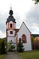
Kreuzwertheim, Evangelical Lutheran Church of the Holy Cross, exterior view

Kreuzwertheim, Evangelical Lutheran Church of the Holy Cross, interior view
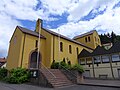
Kreuzwertheim, Catholic Church Heilig Kreuz, exterior view
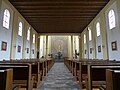
Kreuzwertheim, Catholic Church Heilig Kreuz, interior view with a view of the altar


The community is almost predominantly Catholic. There is the Catholic parish Heiligkreuz (Church of the Holy Cross ) in the main town, the Catholic parish St. Markus in Unterwittbach with the branch St. Josef the Bridegroom in Wiebelbach and the Curate St. Antonius von Padua in Röttbach. There is also the Evangelical Lutheran Church of the Holy Cross and the New Apostolic Church Kreuzwertheim in the main town .
politics
mayor
The mayors since 1888:
- since 2014: Klaus H. Thoma (created by the CSU and the Free Voters' Association), re-elected on March 15, 2020 with 83.4% of the votes.
- 1996-2014: Horst E. Fuhrmann, CSU
- 1984–1996: Christa Schoenberg, CSU
- 1978–1984: Gerald Amarell, Free Voter Association
- 1972–1978: Hans Schneider, CSU († 1978)
- 1945–1972: Philipp Günzelmann, SPD
- 1925–1945: Georg Fröber
- 1906–1925: Andreas Dinkel
- 1888–1905: Georg M. Fröber
Market council
The local elections from 2002 to 2020 led to the following allocation of seats in the municipal council:
| CSU | SPD / PLUS | Free voters association |
total | |
| 2020 | 5 | 6th | 5 | 16 seats |
| 2014 | 5 | 5 | 6th | 16 seats |
| 2008 | 5 | 4th | 7th | 16 seats |
| 2002 | 6th | 4th | 6th | 16 seats |
coat of arms
The description of the coat of arms adopted in 1958 reads: “Divided by silver and blue; above a growing black market cross; below three two-to-one set silver heraldic roses with golden lugs ”.
Architectural monuments
Soil monuments
Economy and Infrastructure

Economy including agriculture and forestry
In 2017 there were 2,261 jobs subject to social security contributions in the municipality. Of the resident population, 1742 people were in an employment relationship subject to compulsory insurance. The number of inbound commuters was 519 larger than that of outbound commuters. 31 residents were unemployed. In 2016 there were nine farms.
Viticulture
Kaffelstein is the most famous wine location on the market.
traffic
The Main is spanned by two road bridges at Kreuzwertheim, the Spessart Bridge to the west and the older Main Bridge Wertheim , which was opened to traffic in 1882. From 1881 to 1984 there was a railway bridge that was next to the older road bridge.
The operation of the Lohr – Wertheim railway was started on October 1, 1881 by the Bavarian State Railways, 1.6 km of the line lay in Baden territory. Passenger traffic between Lohr Stadt and Wertheim train station was discontinued on May 30, 1976, the route was dismantled and the main valley cycle path runs along it for the most part . The railway bridge at Kreuzwertheim was dismantled in 1984 and rebuilt 175 kilometers further up the Main near Schweinfurt on the Kitzingen – Schweinfurt railway line .
Before the construction of the bypass road, the Bavarian State Road 2315 , coming from the Bundesautobahn 3 , led as Lengfurter Straße from the northeast into the main town. Today it bends north after a roundabout north of the western district. There Haslocher Straße, the former state road, leads south into the town. From the same roundabout, state road 508 leads west over the Main Bridge to Baden-Württemberg , which leads to Wertheim and on to federal road 27 near Hardheim .
education
In 2018 there was
- three day-care centers with 185 approved places and 144 children
- a primary school with the first to fourth grade; 175 students were taught in eight classes. The middle school was incorporated into the Marktheidenfeld Middle School by ordinance of the government of Lower Franconia from July 15, 2011 to August 1, 2011.
Transmitter Kreuzwertheim
Personalities
- Ludwig zu Löwenstein-Wertheim-Freudenberg (1864–1899), civil registrar
- Johann Georg Fehn (1880–1950), pastor and politician (DDP), member of the state parliament
literature
- History and local history association Kreuzwertheim e. V. (Ed.): In Kreuzwertheim - Through the year. Yearbooks 1989 ff. , So far 31 vols.
- Manfred Schneider u. a .: 1000 years of Markt Kreuzwertheim. ed. vom Markt Kreuzwertheim 2011, 4th vol., 1500 pp.
- Manfred Schneider: Kreuzwertheim - my piece of Main Franconia. Self-published 1989, 120 pp.
- Manfred Schneider: Kreuzwertheim in old views. European Library, Zaltbommel / NL 1991, 78 pp.
- Manfred Schneider: Hans Lechner - home painter Kreuzwertheim. GHK-Verlag, Kreuzwertheim 1991, 186 pp.
- Manfred Schneider: Praise the nonsense. GHK-Verlag, Kreuzwertheim 1992, 192 pp.
- Manfred Schneider: The patrol book of Sergeant Ludwig Grüner from Kreuzwertheim. GHK-Verlag, Kreuzwertheim 1993, 120 pp.
- Manfred Schneider: Beginning and End of the Third Reich. GHK-Verlag, Kreuzwertheim 1995, 126 pp.
- Manfred Schneider: The riddle about the Wettenburg, myth and truth. GHK-Verlag, Kreuzwertheim 1999, 82 pp.
- Manfred Schneider: A heaven on earth. GHK-Verlag, Kreuzwertheim 1997, 64 pp.
- Manfred Schneider: The writing book of Johann Kaspar Günzelmann III. GHK-Verlag, Kreuzwertheim 1997-2000, 5 vols., 430 pp.
- Manfred Schneider: 50 years of the Holy Cross Church. GHK-Verlag, Kreuzwertheim 2001, 116 pp.
- Manfred Schneider, Viktor Jagodicz: The Lohrer Bahn. (Main focus: Kreuzwertheim) GHK-Verlag, Kreuzwertheim 2005, 228 pp.
- Melchior Joseph Berberich: History of the parish Unterwittbach and its branches . GHK-Verlag, Kreuzwertheim 1998 (reprint), 39 pp.
- Andreas Fries, Otto Langguth, Manfred Schneider: In Kreuzwertheim: Legends of the area. GHK-Verlag, Kreuzwertheim 1995, 102 pp.
- Rolf, RA Hecker: Ludwig Storch - a forgotten poet. GHK-Verlag, Kreuzwertheim 1999, 74 pp.
- Walter Herz: Walter Herz tells about his daring ancestors. GHK-Verlag, Kreuzwertheim 1995, 60 pp.
- Philip Hill: Muntze in the village to the Holy Creeute. GHK-Verlag, Kreuzwertheim 1995, 50 pp.
- Gusti Kirchhoff: Dreams under the pear tree GHK-Verlag, Kreuzwertheim 2000, 112 pp.
- Erich Langguth, Paul Schauber, Manfred Schneider: 400 years of the Peter Herrschaft House in Kreuzwertheim. GHK-Verlag, Kreuzwertheim 1994, 148 pp.
- Heide Wießmeier: Register for the Kreuzwertheim yearbooks 1989 - 2008 . GHK-Verlag, Kreuzwertheim 2010, 74 pp.
- Irmgard and Albert Zeller: The flora of the Kreuzwertheim district. GHK-Verlag, Kreuzwertheim 1992, 114 pp.
Individual evidence
- ↑ "Data 2" sheet, Statistical Report A1200C 202041 Population of the municipalities, districts and administrative districts 1st quarter 2020 (population based on the 2011 census) ( help ).
- ↑ Marktgemeinde Kreuzwertheim in the local database of the Bayerische Landesbibliothek Online . Bayerische Staatsbibliothek, accessed on July 1, 2020.
- ^ Administrative community Kreuzwertheim: Numbers, data . 2014 ( online [accessed April 29, 2014]). online ( Memento of the original from April 29, 2014 in the Internet Archive ) Info: The archive link was inserted automatically and has not yet been checked. Please check the original and archive link according to the instructions and then remove this notice.
- ↑ Landesarchiv-bw.de: R-Rep. 5 Ark IX D No. 3 1344 March26
- ^ Wilhelm Volkert (ed.): Handbook of Bavarian offices, communities and courts 1799–1980 . CH Beck, Munich 1983, ISBN 3-406-09669-7 , p. 518 .
- ↑ a b c Federal Statistical Office (ed.): Historical municipality directory for the Federal Republic of Germany. Name, border and key number changes in municipalities, counties and administrative districts from May 27, 1970 to December 31, 1982 . W. Kohlhammer GmbH, Stuttgart / Mainz 1983, ISBN 3-17-003263-1 , p. 763 .
- ↑ All deaneries. Diocese of Würzburg, accessed on May 3, 2016 .
- ^ Diocese of Würzburg: All deaneries . 2014 ( online [accessed April 23, 2014]).
- ↑ Evangelical Church Community Kreuzwertheim: Our Church and Our Houses . 2014 ( online [accessed April 23, 2014]).
- ↑ Markt Kreuzwertheim: Churches . 2014 ( online [accessed April 23, 2014]). online ( Memento of the original from June 9, 2014 in the Internet Archive ) Info: The archive link was inserted automatically and has not yet been checked. Please check the original and archive link according to the instructions and then remove this notice.
- ↑ 2020 municipal council election , accessed on July 1, 2020
Web links
- Kreuzwertheim
- Unterwittbach
- Entry on the coat of arms of Kreuzwertheim in the database of the House of Bavarian History
- Kreuzwertheim: Official statistics of the LfStat
- Illustration by Daniel Meisner from 1626: Wertheim. Art can be found everywhere ( digitized )
- Article on the organ in the Holy Cross at Organ Index

Arnstein | Aura in the reason | Birkenfeld | Bischbrunn | Burgsinn | Erlenbach near Marktheidenfeld | Esselbach | Eußenheim | Skins | Frammersbach | Gemünden am Main | Gössenheim | Graefendorf | Hafenlohr | Hasloch | Sky city | Karbach | Karlstadt | Karsbach | Kreuzwertheim | Lohr am Main | Marktheidenfeld | Middle sense | Neuendorf | Neuhütten | Neustadt am Main | Obersinn | Partenstein | Rechtenbach | Retzstadt | Rieneck | Clearing | Rothenfels | Schollbrunn | Steinfeld | Thüngen | Triefenstein | Urspringen | Wiesthal | Zellingen
Municipality-free areas in the district of Main-Spessart
Burgjoss |
Forest aura |
Forest Lohrerstraße |
Frammersbach Forest |
Princely Löwensteinscher Park |
Haurain |
Herrnwald |
Langenprozeltener forest |
Partenstein Forest |
Ruppertshütten forest