
Neuhütten (Lower Franconia)
| coat of arms | Germany map | |
|---|---|---|

|
Coordinates: 50 ° 0 ' N , 9 ° 25' E |
|
| Basic data | ||
| State : | Bavaria | |
| Administrative region : | Lower Franconia | |
| County : | Main-Spessart | |
| Management Community : | Partenstein | |
| Height : | 270 m above sea level NHN | |
| Area : | 5.95 km 2 | |
| Residents: | 1138 (Dec. 31, 2019) | |
| Population density : | 191 inhabitants per km 2 | |
| Postal code : | 97843 | |
| Area code : | 06020 | |
| License plate : | MSP | |
| Community key : | 09 6 77 165 | |
| Community structure: | 3 districts | |
| Association administration address: | Hauptstrasse 24 97846 Partenstein |
|
| Website : | ||
| Mayor : | Bernd Steigerwald (Voting Group Together for Neuhütten) | |
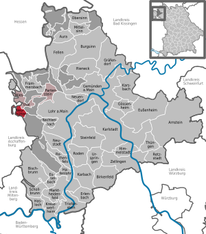
| Location of the community Neuhütten in the Main-Spessart district | ||
  |
||

Neuhütten is a municipality in the Lower Franconian district of Main-Spessart and a member of the Partenstein administrative community .
geography
Geographical location
Neuhütten is located in the Würzburg region in the Bavarian Spessart . The topographically highest point of the municipality is at 472 m above sea level. NN (location) on the eastern slope of the Hengstkopf , near the Bischbornerhof, the lowest is on the Lohrbach at 232 m above sea level. NN (location) .
Community structure
Neuhütten has three districts, which are spread over two districts :
- Neuhütten district
- Neuhütten (village)
- Forest district Lohrer Straße
- Bischbornerhof (wasteland, exclave)
- Lohrerstraße (wasteland, exclave)
- uninhabited exclave "Birkig" (1.1 hectares)
In addition to the district Neuhütten the community also includes a part called district forestry Lohrerstraße which extends over three enclaves stretches that the same unincorporated area forestry Lohrerstraße are surrounded, including the Bischbornerhof and the former forester's house Lohrerstraße.
Neighboring communities
|
Heinrichsthaler Forst (municipality-free area) |
Community Wiesthal |
|
| community Heigenbrücken |
.svg)
|
Partensteiner Forst ( non- parish area) |
|
Forst Hain im Spessart (municipality-free area) |
Rothenbucher Forst (municipality-free area) |
Forst Lohrerstraße (community-free area) |
Surname
etymology
The original place name Breidenstein consists of the Middle High German words broad and stone . It means "wide rock". After the village was destroyed in the Thirty Years War , new huts were built. This is where today's place name comes from. It consists of the Old High German niuwe and the word hütte .
Earlier spellings
Earlier spellings of the place from various historical maps and documents:
|
|
history
Until the church is planted
The year 1349 was first mentioned as Breydenstein in a Mainz document as one of four glassworks in the Spessart . Neuhütten was first used as a place name in 1513 . As part of the archbishopric Mainz Neuhütten fell Reichsdeputationshauptschluss 1803 to the newly formed Principality of Aschaffenburg of Prince Primate von Dalberg, with which (now a department of the Grand Duchy of Frankfurt) led in 1814 to Bavaria. In the course of the administrative reforms in Bavaria, today's municipality was created with the municipal edict of 1818.
Administrative history
In 1862 the district office of Aschaffenburg was formed, on whose administrative area Neuhütten was located. On January 1, 1880, however, Neuhütten came to the Lohr am Main district office to reform the layout of the Bavarian district offices . As everywhere in the German Reich , the term district was introduced in 1939. Neuhütten was now one of the 26 communities in the Lohr am Main district . With the dissolution of the Lohr am Main district, Neuhütten became part of the newly formed Mittelmain district on July 1, 1972, which ten months later received its final name, Main-Spessart district .
Population development
- 1961: 916 inhabitants
- 1970: 1023 inhabitants
- 1987: 1092 inhabitants
- 1991: 1208 inhabitants
- 1995: 1277 inhabitants
- 2000: 1271 inhabitants
- 2005: 1258 inhabitants
- 2010: 1166 inhabitants
- 2015: 1167 inhabitants
politics
mayor
Mayor has been Bernd Steigerwald (Voting Group Together for Neuhütten) since May 1, 2020; he was elected on March 15, 2020 with 58.6% of the vote. His predecessor was Edmund Hirzbeger (* 1949, also together for Neuhütten ) from May 1, 1996 to April 30, 2020 .
coat of arms
Blazon : In red above a six-spoke silver wheel, three silver crystals side by side.
Architectural monuments
Soil monuments
Economy including agriculture and forestry
In 1998, according to official statistics, there were no employees at the place of work subject to social insurance contributions in the manufacturing sector 104 and in the trade and transport sector. There were a total of 463 employees at the place of residence subject to social security contributions. There was one company in the manufacturing sector and one in the main construction sector. In addition, in 1999 there were eleven agricultural holdings with an agriculturally used area of 342 ha, of which 339 ha were permanent green space.
education
In 1999 the following institutions existed:
- a kindergarten with 50 places and 50 children
Web links
- Entry on the coat of arms of Neuhütten (Lower Franconia) in the database of the House of Bavarian History
Individual evidence
- ↑ "Data 2" sheet, Statistical Report A1200C 202041 Population of the municipalities, districts and administrative districts 1st quarter 2020 (population based on the 2011 census) ( help ).
- ↑ http://www.bayerische-landesbibliothek-online.de/orte/ortssuche_action.html ? Anzeige=voll&modus=automat&tempus=+20111119/213136&attr=OBJ&val= 1736
- ^ BayernAtlas
- ↑ a b Wolf-Armin von Reitzenstein : Lexicon of Franconian place names. Origin and meaning . Upper Franconia, Middle Franconia, Lower Franconia. CH Beck, Munich 2009, ISBN 978-3-406-59131-0 , p. 158–159 ( limited preview in Google Book search).

Arnstein | Aura in the reason | Birkenfeld | Bischbrunn | Burgsinn | Erlenbach near Marktheidenfeld | Esselbach | Eußenheim | Skins | Frammersbach | Gemünden am Main | Gössenheim | Graefendorf | Hafenlohr | Hasloch | Sky city | Karbach | Karlstadt | Karsbach | Kreuzwertheim | Lohr am Main | Marktheidenfeld | Middle sense | Neuendorf | Neuhütten | Neustadt am Main | Obersinn | Partenstein | Rechtenbach | Retzstadt | Rieneck | Clearing | Rothenfels | Schollbrunn | Steinfeld | Thüngen | Triefenstein | Urspringen | Wiesthal | Zellingen
Municipality-free areas in the district of Main-Spessart
Burgjoss |
Forest aura |
Forest Lohrerstraße |
Frammersbach Forest |
Princely Löwensteinscher Park |
Haurain |
Herrnwald |
Langenprozeltener forest |
Partenstein Forest |
Ruppertshütten forest