
Lohrbach (Aubach)
|
Lohrbach ( Historically : Heinrichsthaler Lohr ) |
||
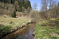
 The Lohrbach near Neuhütten |
||
| Data | ||
| Water code | DE : 245222 | |
| location |
Spessart
|
|
| River system | Rhine | |
| Drain over | Aubach → Lohr → Main → Rhine → North Sea | |
| source | in Heinrichsthal in the Spessart 50 ° 3 '25 " N , 9 ° 20' 45" E |
|
| Source height | 416 m above sea level NHN | |
| muzzle | near Krommenthal in the Aubach Coordinates: 50 ° 1 ′ 5 ″ N , 9 ° 26 ′ 26 ″ E 50 ° 1 ′ 5 ″ N , 9 ° 26 ′ 26 ″ E |
|
| Mouth height | 226 m above sea level NHN | |
| Height difference | 190 m | |
| Bottom slope | 17 ‰ | |
| length | 11.3 km | |
| Catchment area | 53.5 km² | |
| Left tributaries | Short Lohrbach , Bächlesbach | |
| Right tributaries | Hasselbach , Grimmenwiesenbach | |
 Mouth of the Lohrbach (front right) into the Aubach (left) |
||
The Lohrbach is a right tributary of the Aubache in the districts of Aschaffenburg and Main-Spessart in the Bavarian Spessart .
geography
course
The Lohrbach rises at an altitude of 416 m above sea level. NHN on the southern outskirts of Heinrichsthal and runs south on Kreisstraße AB 7. It flows on the edge of the Heinrichsthaler Forest through the two hamlets Ober- and Unterlohrgrund , where it is reinforced by the Lohrborn . Then he crosses the border to the community of Heigenbrücken .
The Lohrbach then takes up the Hasselbach flowing down from the Jakobsthal district and bends in a south-westerly direction at the Eselshöhe ridge . From there, the district road AB 23 accompanies the Lohrbach. Before reaching Heigenbrücken, he reaches the Spessartwiesen nature reserve . In the village, the state road 2317 leads into the valley, which follows the Lohrbach to its mouth. On the right-hand mountain slopes , the Main-Spessart-Bahn line emerged from the Schwarzkopf tunnel until 2017 , which today leads through the Falkenberg tunnel and further west to the Lohrbachtal. In the center of Heigenbrücken the Lohrbach flows into the short Lohrbach . Behind the village it crosses the border to the Main-Spessart district and the Lohrbach reaches the Neuhütten area .
There the Kahltal-Spessart-Radweg leads over the brook. Shortly afterwards it bends to the northeast, takes up the Grimmenwiesenbach and passes under a viaduct of the Main-Spessart Railway. Near the Wiesthal district of Krommenthal, it flows at 226 m above sea level. NHN from the right into the Aubach coming from Wiesen .
In some maps, the Lohrbach is the right source river of the Lohr . The Aubach is seen there as its tributary. The Lohrbach is to be distinguished from the Lohrbach of the same name from Lohrhaupten, the left and official source brook of the Lohr .
Tributaries
- Hasselbach ( right ), Heigenbrücken , 310 m above sea level. NHN
- Kurzer Lohrbach ( left ), Heigenbrücken, 270 m above sea level. NHN
- Bächlesbach ( left ), Heigenbrücken, 255 m above sea level. NHN
- Grimmenwiesenbach ( right ), Neuhütten, 239 m above sea level. NHN
Lohr river system
history
Mills
- Oberlohrgrundmühle (Lohrmühle)
- Unterlohrgrundmühle (Schreinersmühle)
- Mill in Heigenbrücken
- Maidelsmühle
See also the list of mills in the Kahlgrund .
Picture gallery
The Lohrbach:

at Oberlohrgrund

at Unterlohrgrund
before Heigenbrücken

in Heigenbrücken


See also
Web links
Individual evidence
- ↑ Bayernviewer of the Bavarian Surveying Administration: Historical maps from the years 1817–1841 ( Memento of the original from July 24, 2014 in the Internet Archive ) Info: The archive link was inserted automatically and has not yet been checked. Please check the original and archive link according to the instructions and then remove this notice.
- ↑ a b TOP 10 Bavaria North
- ↑ GeoFachDatenAtlas and water services of the Bavarian State Office for the Environment
- ↑ Bavaria Atlas of the Bavarian State Government ( notes )