Lohrbach (Lohr)
| Lohrbach | ||
|
The Lohrbach south of Lohrhaupten |
||
| Data | ||
| location | Main-Kinzig district (Hesse) | |
| River system | Rhine | |
| Drain over | Lohr → Main → Rhine → North Sea | |
| source |
Lohr spring in Lohrhaupten 50 ° 7 ′ 41 ″ N , 9 ° 29 ′ 19 ″ E |
|
| Source height | approx. 360 m above sea level NHN | |
| confluence | with the Flörsbach to Lohr , south of Lohrhaupten Coordinates: 50 ° 6 '2 " N , 9 ° 27' 36" E 50 ° 6 '2 " N , 9 ° 27' 36" E |
|
| Mouth height | approx. 270 m above sea level NHN | |
| Height difference | approx. 90 m | |
| Bottom slope | approx. 20 ‰ | |
| length | 4.5 km | |
| Catchment area | 18.7 km² | |
The Lohrbach is the left, about 4.5 km long source brook of the Lohr in the Main-Kinzig-Kreis in the Hessian Spessart . It is viewed as the upper reaches of the Lohr.
geography
Lohrquelle
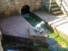
The Lohrbach rises in Lohrhaupten (municipality of Flörsbachtal ) from two heavily pouring springs. The upper, weaker one is on the street in the Lohr and bears the official name Lohrquelle . The source outlet is located in a red sandstone wall. At times, a mostly dry-falling stream flows from the Wohnroder valley into the source area. The bronze figure “Lohrchen” sits directly at the source .
course
The Lohrbach leaves Lohrhaupten in a southerly direction and unites near the Ziegelhütte with the Flörsbach to Lohr coming from the northwest .
See also
Web links
Commons : Lohrbach (Lohrhaupten) - Collection of images, videos and audio files
Individual evidence
- ↑ a b c d Water map service of the Hessian Ministry for the Environment, Climate Protection, Agriculture and Consumer Protection ( information )


