
Flörsbach (Lohr)
| Flörsbach | ||
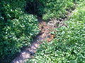
 The Flörsbach between Flörsbach and Kempfenbrunn |
||
| Data | ||
| Water code | DE : 2452112 | |
| location |
Spessart
|
|
| River system | Rhine | |
| Drain over | Lohr → Main → Rhine → North Sea | |
| source | near Flörsbach in the Spessart 50 ° 7 ′ 53 ″ N , 9 ° 24 ′ 21 ″ E |
|
| Source height | approx. 400 m above sea level NHN | |
| confluence | with the Lohrbach to Lohr , south of Lohrhaupten Coordinates: 50 ° 6 '2 " N , 9 ° 27' 36" E 50 ° 6 '2 " N , 9 ° 27' 36" E |
|
| Mouth height | approx. 270 m above sea level NHN | |
| Height difference | approx. 130 m | |
| Bottom slope | approx. 22 ‰ | |
| length | 5.9 km | |
| Catchment area | 14.933 km² | |
| Discharge A Eo : 14.933 km² at the mouth |
MQ Mq |
163.1 l / s 10.9 l / (s km²) |
The Flörsbach is the right source brook of the Lohr in the Main-Kinzig district in the Hessian Spessart .
geography
course
The source of the Flörsbach is in the village of the same name, Flörsbach , which belongs to the municipality of Flörsbachtal . It rises from several sources next to a small lake.
Then it flows through the village pond in the center of the village. After about six kilometers, the Flörsbach merges from the right with the Lohrbach coming from the north below the Flörsbachtal district of Kempfenbrunn , creating the Lohr .
The main source of the Flörsbach

Pond at the Flörsbach spring


Lohr river system
See also
Web links
Commons : Flörsbach - collection of images, videos and audio files