
Heinrichsthal
| coat of arms | Germany map | |
|---|---|---|

|
Coordinates: 50 ° 4 ′ N , 9 ° 21 ′ E |
|
| Basic data | ||
| State : | Bavaria | |
| Administrative region : | Lower Franconia | |
| County : | Aschaffenburg | |
| Management Community : | Heigenbrücken | |
| Height : | 436 m above sea level NHN | |
| Area : | 4.52 km 2 | |
| Residents: | 838 (Dec. 31, 2019) | |
| Population density : | 185 inhabitants per km 2 | |
| Postal code : | 63871 | |
| Area code : | 06020 | |
| License plate : | AB , ALZ | |
| Community key : | 09 6 71 128 | |
| Community structure: | 3 districts | |
| Address of the municipal administration: |
Schulstrasse 9 63871 Heinrichsthal |
|
| Website : | ||
| Mayor : | Udo Kunkel ( Independent Citizens ) | |
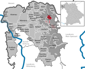
| Location of the community Heinrichsthal in the district of Aschaffenburg | ||
  |
||

Heinrichsthal is a municipality in the Lower Franconian district of Aschaffenburg . It is the highest municipality in the entire Spessart and the smallest independent municipality in the Aschaffenburg district.
geography
Geographical location
The community is located in the Bavarian Lower Main region at the upper end of the Lohrbach valley . The topographically highest point of the municipality district is the height of Schindershöh with 522 m above sea level. NN (location) , the lowest is on the Lohrbach near Unterlohrgrund at 313 m above sea level. NN (location) . The Kahltal-Spessart cycle path runs through the village . The Degen-Weg ended in Heinrichsthal until 2011 .
Community structure
There are three districts in one district :
- Heinrichsthal
Townscape
Thanks to its high plateau location, Heinrichsthal has an unusual appearance for a Spessartorte and is not - as the name suggests - in a typical Spessart valley. The streets go in a star shape from the village square to the comparatively gentle heights of the village. Since tourism has never played a role in Heinrichsthal, the townscape is predominantly characterized by one- and two-family houses.
Neighboring communities
|
Schöllkrippener Forst (community-free area) |
Wiesener Forst (community-free area) |
|
|
Heinrichsthaler Forst (municipality-free area) |
.svg)
|
Heinrichsthaler Forst (municipality-free area) |
| community Heigenbrücken |
Surname
etymology
The name Heinrichsthal goes back to the personal name Heinrich Fleckenstein , the first glassmaker in town. The basic words in the place name are both the landscape designation valley and occasionally the hut .
Earlier spellings
Earlier spellings of the place from various historical maps and documents were:
- 1669 Heinrichshütte
- 1679 Heinrichstal
- 1683 Heinrichsthal
- 1694 Henricushütt
- 1792 Heinrichsthal
history
Until the church is planted
In 1636 the name of the master of a glassworks that was in this region appeared for the first time . Heinrich Fleckenstein from the glassworks in Wollersbuch. Another smelter is also named in 1639, Jacob Fleckenstein . In 1647 Heinrich Fleckenstein's glassworks stood in Lohrgrund , but did not burn out for 34 weeks. An account book from 1652 shows that Heinrich and Jacob were brothers. In 1664, the two place names "Heinrichs grundt undt Jacobs thael" appeared for the first time as a location name. The latter became today's village of Jakobsthal . The year 1678 entered a new stage in local history, because Heinrichsthal was mentioned as a village for the first time in this year . The first taxes had to be paid for seven houses and ten cattle.
The initials of Heinrich Fleckenstein were transferred to the Heinrichsthaler crest.

As part of the archbishopric of Mainz , Heinrichsthal fell to the newly formed principality of Aschaffenburg in the secularization of 1803 by the prince-primate von Dalberg. After that, Heinrichsthal was in the Rothenbuch district fair of the Aschaffenburg department in the Grand Duchy of Frankfurt . In 1812 it had two grinding mills, 72 fireplaces and 420 souls (residents). Maire was Johann Adam Brönner, his adjuncts were Philipp Göbig and Peter Wenzel. The school teacher was Jacob Ritschel. As a result of the treaties of Paris Heinrichsthal came to Bavaria in 1814 and initially belonged to the second-class district court Rothenbuch, which was founded on October 1, 1814. Today's municipality was created in the course of the administrative reforms in Bavaria with the municipality edict of 1818 .
19th and 20th centuries
On September 3, 1858, the district court Schöllkrippen was formed from parts of the district court districts of Alzenau and Aschaffenburg and from the communities of Jakobsthal and Heinrichsthal of the district court district of Rothenbuch. A few years later, on July 1, 1862, the district office of Alzenau was formed from the district court Schöllkrippen. The Alzenau district office was renamed the Alzenau district in Lower Franconia on January 1, 1939. When it was dissolved, Heinrichsthal came to the Aschaffenburg district on July 1, 1972.
Population development
- 1686: 49 inhabitants
- 1812: 420 inhabitants
- 1900: 548 inhabitants
- 1970: 848 inhabitants
- 1987: 892 inhabitants
- 1991: 902 inhabitants
- 1995: 953 inhabitants
- 2000: 952 inhabitants
- 2005: 919 inhabitants
- 2010: 869 inhabitants
- 2015: 835 inhabitants
politics
The community is a member of the Heigenbrücken administrative community .
Municipal council
The municipal council has 8 members. Another member and chairman of the municipal council is the mayor. In the local elections on March 15, 2020, 544 of the 722 residents eligible to vote in the Heinrichsthal community exercised their right to vote, bringing the turnout to 75.35%.
mayor
In the local elections on March 15, 2020, Udo Kunkel (UBH) was elected with 82.71% of the vote. His predecessor was Guido Schramm (Independent Citizen), in office from October 5, 1987 to April 30, 2020.
coat of arms
|
|
Blazon : "Under a silver shield head, inside a continuous red bar cross, in red diagonally crossed a silver cracking iron and a silver ax, separated from the silver capital letters H and F." |
Architectural monuments
Soil monuments
Economy and Infrastructure
The municipal tax receipts amounted to 692,000 € in 2009, of which the trade tax receipts (net) amounted to 270,000 € and the municipal share of income tax was 323,000 €. The municipality's share of sales tax was € 13,000.
Economy including agriculture and forestry
According to official statistics, there were 87 employees at the place of work in 2009. Including 56 in the manufacturing industry, five in trade, transport and hospitality and ten with corporate service providers who are subject to social security contributions. There were a total of 318 employees at the place of residence subject to social insurance contributions. This results in a negative commuter balance, i.e. 231 more outbound than inbound commuters. In Heinrichsthal there were no companies with 20 or more employees in 2009.
In addition, in 2009 there were eight farms with an agriculturally used area of 267 hectares, 186 hectares of which were arable land and 81 hectares of permanent green area.
education
There are the following institutions (status: 2010):
- Kindergarten: 28 kindergarten places with 19 children
telecommunications
There is a 108 meter high telecommunications tower of the Deutsche Telekom AG of the type FMT 5.![]()
Web links
Individual evidence
- ↑ "Data 2" sheet, Statistical Report A1200C 202041 Population of the municipalities, districts and administrative districts 1st quarter 2020 (population based on the 2011 census) ( help ).
- ↑ Municipal Council. Congregation, accessed August 15, 2020 .
- ↑ http://www.bayerische-landesbibliothek-online.de/orte/ortssuche_action.html ? Anzeige=voll&modus=automat&tempus=+20111121/233747&attr=OBJ&val= 1539
- ↑ a b Wolf-Armin von Reitzenstein : Lexicon of Franconian place names. Origin and meaning . Upper Franconia, Middle Franconia, Lower Franconia. CH Beck, Munich 2009, ISBN 978-3-406-59131-0 , p. 98 ( limited preview in Google Book search).
- ↑ a b Our Kahlgrund 1974 . Homeland yearbook for the Alzenau district. Published by the working group for homeland research and homeland maintenance of the Alzenau district, district administrator. ISSN 0933-1328 .
- ↑ Results of local elections 2020. OK.VOTE, March 15, 2020, accessed on May 19, 2020 .
- ↑ Results of local elections 2020. OK.VOTE, March 15, 2020, accessed on May 19, 2020 .
- ↑ Results of local elections 2020. OK.VOTE, March 15, 2020, accessed on May 19, 2020 .
- ^ Entry on Heinrichsthal's coat of arms in the database of the House of Bavarian History

Alzenau | Bessenbach | Blankenbach | Dammbach | Geiselbach | Glattbach | Goldbach | Großostheim | Haibach | Heigenbrücken | Heimbuchenthal | Heinrichsthal | Hösbach | Johannesberg | Kahl am Main | Karlstein am Main | Small bald | Kleinostheim | Krombach | Laufach | Mainaschaff | Mespelbrunn | Mömbris | Rothenbuch | Sailauf | Schöllkrippen | Summer bald | Stockstadt am Main | Waldaschaff | Weibersbrunn | Western reason | grasslands
Unregulated areas: Forst Hain i.Spessart |
Heinrichsthaler Forst |
Rohrbrunner Forest |
Rothenbuch Forest |
Sailauf Forest |
Schöllkrippen Forest |
Waldaschaffer Forest |
Wiesen forest