
Western reason
| coat of arms | Germany map | |
|---|---|---|

|
Coordinates: 50 ° 7 ' N , 9 ° 15' E |
|
| Basic data | ||
| State : | Bavaria | |
| Administrative region : | Lower Franconia | |
| County : | Aschaffenburg | |
| Management Community : | Schöllkrippen | |
| Height : | 284 m above sea level NHN | |
| Area : | 14.77 km 2 | |
| Residents: | 1918 (Dec. 31, 2019) | |
| Population density : | 130 inhabitants per km 2 | |
| Postal code : | 63825 | |
| Area code : | 06024 | |
| License plate : | AB , ALZ | |
| Community key : | 09 6 71 159 | |
| Community structure: | 4 districts | |
| Association administration address: | Marktplatz 1 63825 Schöllkrippen |
|
| Website : | ||
| Mayoress : | Brigitte Heim (WE) | |
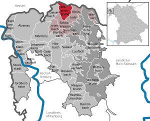
| Location of the municipality Westerngrund in the district of Aschaffenburg | ||
  |
||


Westerngrund is a municipality in the Lower Franconian district of Aschaffenburg and a member of the Schöllkrippen administrative community .
geography
Geographical location
Westerngrund is located in the Bavarian Lower Main region in the district of Aschaffenburg am Westerbach and belongs to the Kahlgrund landscape .
After Croatia joined the European Union , from July 1, 2013 until Brexit on January 31, 2020, the geographical center of the European Union was in the area of the municipality of Westerngrund in the district of Oberwestern (Lage) . This point is also a geodetic reference point .
The topographically highest point of the municipality is at the Franzosenkopf 481 m above sea level. NN (location) , the lowest is on the Westerbach at the Klotzenmühle at 213 m above sea level. NN (location) .
Community structure
Four districts belong to Westerngrund (the number of residents in brackets) in 3 districts :
- Huckelheim (834)
- Upper Western (706)
- Unterwestern (368)
To the north of Huckelheim is another uninhabited area (not a district), the Geiselbach Forest . This formerly community-free area was partially incorporated into Westerngrund in 2015.
Neighboring communities
| Municipality of pottage | ||
| Community Geiselbach |
.svg)
|
Community Kleinkahl |
| Schöllkrippen market |
Surname
Origin of name
The municipality of Westerngrund got its name from its location in the side valley of the same name of the Kahlgrund. The name of the Westerngrund is derived from the Westerbach (originally Westernkahl or just Western ), which flows through it and flows into the Kahl in Schöllkrippen . The community is popularly known as "Weestern".
Earlier spellings
Earlier spellings from various historical maps and documents. These forms of name refer to the village of Oberwestern .
|
|
history
Until the church is planted
The present-day community Westerngrund largely comprises areas that belonged to the Count of Schönborn's office in Krombach, which was mediatized by the Principality of Aschaffenburg in 1806 and which came to Bavaria in 1814 (now a department of the Grand Duchy of Frankfurt ) . In the course of the administrative reforms in Bavaria, the municipal edict of 1818 created the municipalities of Huckelheim, Oberwestern and Unterwestern.
Administrative history
On July 1, 1862, the Alzenau District Office was formed, on whose administrative territory the three communities were located. In 1939, as everywhere in the German Reich, the designation district was introduced. Huckelheim, Oberwestern and Unterwestern now belonged to the 42 communities in the Alzenau district in Lower Franconia .
Merger and Incorporation
On January 1, 1972, the three communities merged to form the new community Westerngrund. and when the Alzenau district was dissolved, it was transferred to the newly formed Aschaffenburg district on July 1st of that year .
On January 1, 2015, the eastern part of the dissolved municipality-free area Geiselbacher Forst , as a district of the same name, was added to the municipality.
On January 1, 2019, the western part of the dissolved community-free area of Huckelheimer Wald with an area of 4.37 km² was added to the community area. It was assigned to the Huckelheim district.
Population development
- 1961: 1378 inhabitants
- 1970: 1454 inhabitants
- 1987: 1584 inhabitants
- 1991: 1701 inhabitants
- 1995: 1835 inhabitants
- 2000: 1918 inhabitants
- 2005: 1888 inhabitants
- 2010: 1920 inhabitants
- 2015: 1936 inhabitants
politics
Municipal council
The municipality council of the municipality Westerngrund consists of twelve council members. This is the fixed number for a municipality with a population between 1001 and 2000. The municipal council is elected for a six-year term.
The first mayor is also entitled to vote in the council of the municipality. This is Brigitte Heim from the community of voters WIR.
The last local election on March 16, 2014 resulted in the following:
| Political party | Number of seats | change |
|---|---|---|
| CSU / BWV | 6th | ± 0 |
| Free voters | 3 | ± 0 |
| WE | 3 | ± 0 |
mayor
The first mayor of the municipality of Westerngrund is Brigitte Heim from the WIR voter community. In the last mayoral election on March 16, 2014, she narrowly prevailed with 51.9% of the vote against Ingrid Simon from the CSU with 48.1%. The turnout was 63.1%. On March 15, 2020, it was confirmed for a further six years with 86.4% of the vote.
coat of arms
Blazon : In red a growing, blue crowned and blue armored golden lion holding a golden shepherd's shovel in his front paws; in the upper left corner two silver miner's hammers crossed at an angle.
Coat of arms history: The lion in the coat of arms and the colors are taken from the coat of arms of the Counts of Schönborn , who owned the municipality until the end of the old empire in 1803. The shepherd's shovel held by the lion is the symbol of St. Wendelin , the patron saint of the community. The crossed miner's hammers represent the former silver and copper mines in the Huckelheim district. The municipality has had the coat of arms since March 24, 1980.
Culture and sights

.jpg)
- The geographic center of the European Union was from May 10, 2014 to January 31, 2020 on the territory of the municipality.
Architectural monuments
Economy and Infrastructure
Economy including agriculture and forestry
In 1998, according to official statistics, there were no employees at the place of work in the manufacturing industry 74 or in the trade and transport sector. There were a total of 715 employees at the place of residence subject to social security contributions. There were three companies in the manufacturing sector and two in the construction sector. In addition, in 1999 there were 30 farms with an agriculturally used area of 722 ha, of which 408 ha were arable land and 313 ha were permanent green space.
education
There is a Catholic kindergarten in Westerngrund.
There is also the Westerngrund elementary school and the Kahlgrund / Spessart eV adult education center
(There is no information about the status or the number of children):
Individual evidence
- ↑ "Data 2" sheet, Statistical Report A1200C 202041 Population of the municipalities, districts and administrative districts 1st quarter 2020 (population based on the 2011 census) ( help ).
- ↑ Westerngrund is the center of the European Union
- ↑ The center is a damp meadow in Oberwestern
- ↑ residents of Westerngrund (as of June 20, 2012)
- ↑ bayerische-landesbibliothek-online.de
- ↑ a b Wolf-Armin von Reitzenstein : Lexicon of Franconian place names. Origin and meaning . Upper Franconia, Middle Franconia, Lower Franconia. CH Beck, Munich 2009, ISBN 978-3-406-59131-0 , p. 240–241 ( limited preview in Google Book search).
- ^ Wilhelm Volkert (ed.): Handbook of Bavarian offices, communities and courts 1799–1980 . CH Beck, Munich 1983, ISBN 3-406-09669-7 , p. 418 .
- ↑ No. 20/2014
- ↑ Government of Lower Franconia: No. 12-1406-1-4: Ordinance on the incorporation of the community-free area "Huckelheimer Wald" into the communities Westerngrund and Kleinkahl, district of Aschaffenburg ( Official Gazette of the Government of Lower Franconia, p. 2. Wikimedia Commons, PDF)
- ↑ Municipal Code for the Free State of Bavaria (Municipal Code - GO) in the version published on August 22, 1998; Art. 31 - Composition of the municipal council , accessed on July 11, 2014.
- ↑ a b Close victory for Brigitte Heim in Westerngrund , accessed on July 12, 2014.
Web links
- Entry on the coat of arms of Westerngrund in the database of the House of Bavarian History

Alzenau | Bessenbach | Blankenbach | Dammbach | Geiselbach | Glattbach | Goldbach | Großostheim | Haibach | Heigenbrücken | Heimbuchenthal | Heinrichsthal | Hösbach | Johannesberg | Kahl am Main | Karlstein am Main | Small bald | Kleinostheim | Krombach | Laufach | Mainaschaff | Mespelbrunn | Mömbris | Rothenbuch | Sailauf | Schöllkrippen | Summer bald | Stockstadt am Main | Waldaschaff | Weibersbrunn | Western reason | grasslands
Unregulated areas: Forst Hain i.Spessart |
Heinrichsthaler Forst |
Rohrbrunner Forest |
Rothenbuch Forest |
Sailauf Forest |
Schöllkrippen Forest |
Waldaschaffer Forest |
Wiesen forest