
Rothenbuch
| coat of arms | Germany map | |
|---|---|---|

|
Coordinates: 49 ° 58 ' N , 9 ° 24' E |
|
| Basic data | ||
| State : | Bavaria | |
| Administrative region : | Lower Franconia | |
| County : | Aschaffenburg | |
| Height : | 365 m above sea level NHN | |
| Area : | 7.05 km 2 | |
| Residents: | 1770 (Dec. 31, 2019) | |
| Population density : | 251 inhabitants per km 2 | |
| Postcodes : | 63860, 97840 | |
| Primaries : | 06094, 09352 | |
| License plate : | AB , ALZ | |
| Community key : | 09 6 71 148 | |
| LOCODE : | DE RT4 | |
| Community structure: | 4 districts | |
| Address of the municipal administration: |
Schloßplatz 1 63860 Rothenbuch |
|
| Website : | ||
| Mayor : | Markus Fäth ( SPD ) | |
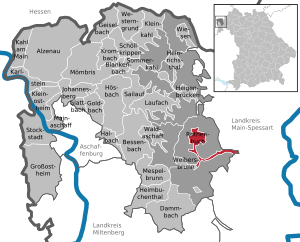
| Location of the community Rothenbuch in the district of Aschaffenburg | ||
  |
||

Rothenbuch is a municipality in the Lower Franconian district of Aschaffenburg .
geography
Geographical location
Rothenbuch is located in the Bavarian Lower Main region , in the heart of Germany's largest deciduous forest, the Spessart . The hamlets of Lichtenau and Erlenfurt in the Hafenlohrtal, which are about 8 and 9 km away respectively, also belong to the municipality of Rothenbuch, which have the postcode of the municipality of Hafenlohr (Main-Spessart district), but are still in the Aschaffenburg district. Rothenbuch has a convenient location between the Rhine-Main area with its metropolis Frankfurt am Main and the Würzburg region . The closest town is Lohr am Main in the east. The Frankfurt Airport can be reached in about 40 minutes, closest ICE -Bahnhof is Aschaffenburg (20 minutes). The topographically highest point of the municipality district is located at 470 m above sea level. NN (location) southeast of the village, on a secondary peak of the Königsberg, the lowest is near Erlenfurt an der Hafenlohr at 231 m above sea level. NN (location) .
Community structure
Rothenbuch has four districts in one area :
- Rothenbuch
- Erlenfurt (ZIP: 63860, Area Code: 06094)
- Lichtenau (ZIP: 97840, Area Code: 09352)
- Steinmühle (ZIP: 97840, Area Code: 09352)
Neighboring communities
|
Rothenbucher Forst (municipality-free area) |
||
| Rothenbucher Forst (municipality-free area) |
.svg)
|
Rothenbucher Forst (municipality-free area) |
| Community Weibersbrunn |
Rohrbrunner Forst (municipality-free area) |
Fürstlich Löwensteinscher Park (community-free area) |
Surname
etymology
The original name Rodenboychen consists of the Old High German words rod and poiche and means red beech .
Earlier spellings
Earlier spellings of the place from various historical maps and documents:
|
|
history

Until the 19th century
Rothenbuch is one of the oldest and most important places in the Innerspessart. The first documented mention of "zuo den Rodenboychen" comes from the year 1318, when the Archbishop of Mainz Peter von Aspelt and the Würzburg Bishop Gottfried III. von Hohenlohe signed a contract here on cooperation in security matters.
In 1342, at the source of the Hafenlohr , the construction of a castle in Rothenbuch began. The first residents are likely to have settled near the castle as hunting patrons. During the Peasants' War in 1525, the castle was badly damaged or destroyed. In 1566 the palace was rebuilt and expanded on the instructions of the Mainz Elector Daniel Brendel von Homburg . A first illustration of Rothenbuch can be found on one of the oldest existing Spessart maps, the so-called Pfinzigkarte from 1594.
Rothenbuch achieved its greatest political importance through the creation of the Rothenbuch winery , a financial and administrative authority for 14 places in the Hochspessart. In 1782 Rothenbuch is declared the seat of the district bailiff . The office of Archbishopric Mainz fell with this in the Reichsdeputationshauptschluss 1803 to the newly formed Principality of Aschaffenburg , with which it came to Bavaria in 1814 (now a department of the Grand Duchy of Frankfurt ) . On June 3, 1814, Rothenbuch became the seat of a Kgl. Bavarian Regional Court, which was dissolved again in 1879.
In 1862 the district office of Aschaffenburg was formed, on whose administrative area Rothenbuch was located. On January 1, 1880, however, Rothenbuch came to the Lohr am Main district office on the occasion of the reform of the layout of the Bavarian district offices .
20th century
As everywhere in the German Reich , the term district was introduced in 1939. Rothenbuch was now one of the 26 communities in the Lohr am Main district . With the dissolution of the Lohr district, Rothenbuch came to the newly formed Aschaffenburg district on July 1, 1972 .
Administrative community
From May 1, 1978 made up to 31 December 1993 Roth book Waldaschaff the administrative community Waldaschaff ; the community of Weibersbrunn also belonged to the corporation from May 1, 1978 to December 31, 1979. On January 1, 1994, Rothenbuch received full communal independence as a unified congregation with its own administration.
Population development
- 1900: 993 inhabitants
- 1950: 1476 inhabitants
- 1961: 1330 inhabitants
- 1970: 1470 inhabitants
- 1991: 1798 inhabitants
- 1995: 1884 inhabitants
- 2000: 1890 inhabitants
- 2005: 1920 inhabitants
- 2010: 1878 inhabitants
- 2015: 1764 inhabitants
politics
Municipal council
The Rothenbuch municipal council has 12 members plus the full-time mayor. The parties or groups of voters received the following mandates:
| SPD | CSU | Free citizens | total | |
| 2020 | 6th | 4th | 2 | 12 municipal councils |
| 2014 | 6th | 3 | 3 | 12 municipal councils |
(Status: local election on March 15, 2020 )
mayor
Markus Fäth (SPD) has been mayor since May 1, 2020. He was elected on March 15, 2020 with 94.3% of the vote, the voter turnout was 75.9%. His predecessor was Gerhard Aulenbach (SPD) from May 1, 2002 to April 30, 2020; when he was last re-elected on March 16, 2014, he received 94.5% of the vote.
coat of arms
The Mainz wheel indicates that Rothenbuch has been part of the Electorate and Archdiocese of Mainz for almost 500 years. The beech and deer antlers symbolize forest and hunting.
Culture and sights
Rothenbuch Castle

The castle is first mentioned in a document dated July 3, 1318. The current building is a former hunting lodge , which was built in 1567 according to plans by Daniel Brendel von Homburg . The facility with four wings has a rectangular inner courtyard with a polygonal stair tower in the north building. The two access bridges make it clear that it was originally a moated castle. The Hafenlohr rises in the castle moat and filled the moat and the nearby, fish-rich smaller lakes. The castle served as the central administrative seat in the Spessart and was court for 14 surrounding villages for two centuries. From 1994 until today it was used as a hotel. It has been marketed as a seminar house for corporate events since 2017.
Architectural monuments
- The forester's house from 1576 was taken over by the state forestry company in October 2013 after six years of renovation.
Soil monuments
Other attractions
- European cultural hiking trail of the Archaeological Spessart Project
- Local history museum old farmhouse
- Germany's most impressive oak stands are located in the Rothenbucher Forest . The Heisterblock forest department is the largest and oldest oak forest in Central Europe.
- Nationally known and worth seeing is the historic Christmas market, which takes place on the first weekend of Advent, with more than 15,000 visitors. The city newspaper Aschaffenburg described the Christmas market in Rothenbuch with the comment "This is where Santa Claus feels at home" as the most beautiful Christmas market in the entire Bavarian Lower Main.
Economy and Infrastructure
The municipal tax revenue in 2014 amounted to € 1,265,000. The trade tax income (net) amounted to € 171,000. The municipality's per capita debt is € 0.
According to official statistics, there were 68 employees at the place of work in the manufacturing sector and 42 in the trade, transport and hospitality sector. In other economic areas, 89 people were employed at the place of work subject to social security contributions. There were a total of 730 employees in the place of residence subject to social insurance contributions. The statistics for 2014 show a commuter balance of −523 people. There are two companies in the main construction trade and three in the ancillary construction trade. In addition, there are two farms with an agriculturally used area of 157 ha as permanent green space.
traffic
Rothenbuch is 7 kilometers from the A3 federal motorway (Weibersbrunn exit). The federal highway 26 Aschaffenburg- Würzburg runs at a distance of 3 kilometers. Rothenbuch is served by buses from Aschaffenburg and Lohr.
education
There are the following institutions (as of 2015):
- Kindergartens: 75 kindergarten places with 66 children
- Primary schools: 1 with 3 teachers and 48 students
Sons and daughters of the church
- Johann Adam Hasenstab (born September 21, 1716 in Rothenbuch; † June 3, 1773 near Schollbrunn ), most famous poacher and legendary figure of the Spessart.
- Father Augustin Krimm OSB (born August 2, 1869 in Rothenbuch, † May 25, 1930 in Ottobeuren ), prior of the Ottobeuren Benedictine Abbey. Controversial because of early contacts with the NSDAP , u. a. a consecration of SA standards on August 19, 1923, prevented at the last moment by the responsible diocesan administration .
- Carl Brand (born August 21, 1893 in Rothenbuch; † April 2, 1945 in Lohr am Main ), general practitioner and Nazi victim. In the last days of the Second World War, Brand wanted to hand over the Lower Franconian city of Lohr am Main, where he was working at the time, to the US troops without a fight and thus prevent the senseless destruction of the city. His plan was rumored, he was arrested by the Gestapo and shot after a court martial. A memorial stone in Lohr has been commemorating this since 1979. A street in Rothenbuch was named after him in 1980 and in Lohr in 2008.
- Rudolf Hasenstab (born June 17, 1932 in Rothenbuch), professor of moral theology and social ethics at the Catholic University of Eichstätt-Ingolstadt 1977–1998. Honorary citizen of the municipality of Eitensheim .
Awards
- 2005 district winner competition " Our village has a future "
- 2006 2nd place in Lower Franconia competition "Our village has a future"
- 2006 district winner competition "Lively green in town and country"
- 2006 "Most beautiful Christmas market on the Bavarian Lower Main" (according to the city newspaper Aschaffenburg)
- 2008 district winner competition "Our village has a future"
- 2009 1st place in Lower Franconia competition "Our village has a future"
- 2009 silver medal at the Bavarian state level "Our village has a future"
- 2016 district winner competition "Our village has a future"
literature
- Hastings, Derek .: Catholicism and the Rise of Nacism; Oxford / New York 2009, p. 125.
Web links
- Official homepage of the municipality
- Entry on the Rothenbuch coat of arms in the database of the House of Bavarian History
Individual evidence
- ↑ "Data 2" sheet, Statistical Report A1200C 202041 Population of the municipalities, districts and administrative districts 1st quarter 2020 (population based on the 2011 census) ( help ).
- ↑ http://www.bayerische-landesbibliothek-online.de/orte/ortssuche_action.html ? Anzeige=voll&modus=automat&tempus=+20111122/214002&attr=OBJ&val= 1550 .
- ↑ a b Wolf-Armin von Reitzenstein : Lexicon of Franconian place names. Origin and meaning . Upper Franconia, Middle Franconia, Lower Franconia. CH Beck, Munich 2009, ISBN 978-3-406-59131-0 , p. 193 ( limited preview in Google Book search).
- ↑ https://www.statistik.bayern.de/statistikkommunal/09671148.pdf
- ↑ Election result on rothenbuch.de , accessed on June 20, 2020
- ↑ Matthaes Verlag GmbH, Stuttgart, Germany: Châteauform operator group relies on locks . In: AHGZ.de . ( ahgz.de [accessed on August 31, 2017]).
- ↑ Surprises under the floorboards in FAZ of October 18, 2013, page 62.
- ↑ Board of the cultural hiking trail
- ↑ https://www.statistik.bayern.de/statistikkommunal/09671148.pdf
- ↑ https://www.statistik.bayern.de/statistikkommunal/09671148.pdf
- ↑ Ulrike Puvogel: Baden-Württemberg, Bavaria, Bremen, Hamburg, Hesse, Lower Saxony, North Rhine-Westphalia, Rhineland-Palatinate, Saarland, Schleswig-Holstein . In: Memorials for the Victims of National Socialism: a Documentation . 2., revised. u. exp. Edition. tape 1 . Federal Agency for Political Education , Bonn 1995, ISBN 3-89331-208-0 , p. 190 .
- ↑ http://www.main-netz.de/nachrichten/region/frankenrhein-main/franken-kurz/art4006,799511
- ↑ http://www.main-netz.de/themen/spessart/spessartnachrichten/art13292,981467
- ↑ http://www.main-echo.de/regional/stadt-kreis-aschaffenburg/art3986,4254669
- ^ Derek Hastings: Catholicism and the Roots of Nazism. Oxford University Press, 2009, ISBN 978-0-199-74141-0 , p. 125 ( limited preview in Google Book Search).

Alzenau | Bessenbach | Blankenbach | Dammbach | Geiselbach | Glattbach | Goldbach | Großostheim | Haibach | Heigenbrücken | Heimbuchenthal | Heinrichsthal | Hösbach | Johannesberg | Kahl am Main | Karlstein am Main | Small bald | Kleinostheim | Krombach | Laufach | Mainaschaff | Mespelbrunn | Mömbris | Rothenbuch | Sailauf | Schöllkrippen | Summer bald | Stockstadt am Main | Waldaschaff | Weibersbrunn | Western reason | grasslands
Unregulated areas: Forst Hain i.Spessart |
Heinrichsthaler Forst |
Rohrbrunner Forest |
Rothenbuch Forest |
Sailauf Forest |
Schöllkrippen Forest |
Waldaschaffer Forest |
Wiesen forest