
Glattbach
| coat of arms | Germany map | |
|---|---|---|

|
Coordinates: 50 ° 0 ' N , 9 ° 9' E |
|
| Basic data | ||
| State : | Bavaria | |
| Administrative region : | Lower Franconia | |
| County : | Aschaffenburg | |
| Height : | 182 m above sea level NHN | |
| Area : | 3.53 km 2 | |
| Residents: | 3328 (Dec. 31, 2019) | |
| Population density : | 942 inhabitants per km 2 | |
| Postal code : | 63864 | |
| Area code : | 06021 | |
| License plate : | AB , ALZ | |
| Community key : | 09 6 71 120 | |
| LOCODE : | DE GHC | |
| Community structure: | 2 districts | |
| Address of the municipal administration: |
Schulstrasse 17 63864 Glattbach |
|
| Website : | ||
| Mayor : | Kurt Baier ( CSU ) | |
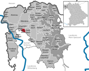
| Location of the municipality of Glattbach in the Aschaffenburg district | ||
  |
||


Glattbach is a municipality in the Lower Franconian district of Aschaffenburg .
geography
Geographical location
The community is located north of Aschaffenburg on the western edge of the Spessart in the valley of the Glattbach . The topographically highest point of the municipality mark is on the Hainberg southwest of Oberafferbach at 320 m above sea level. NN (location) , the lowest is on the Glattbach south of the village at 158 m above sea level. NN (location) . The Franconian Marienweg leads through Glattbach .
Community structure
Glattbach has two districts:
- Glattbach
- Rauenthal
There is only the Glattbach district .
Neighboring communities
| Johannesberg parish | ||
.svg)
|
Goldbach market | |
| City of Aschaffenburg |
Surname
etymology
Glattbach takes its name from the eponymous Glattbach , which flows through the municipality to Aschaffenburg and flows into the Aschaff .
Earlier spellings
Earlier spellings of the place from various historical maps and documents:
|
|
history

Until the 18th century
Due to the location of Glattbach, in the 12th century Gladebach , also called Gladbach , in a closed valley, there was no through traffic. Nevertheless, Glattbach was not spared in times of emergency and war, which was probably due to the proximity of the city of Aschaffenburg, but also to Gelnhäuser Strasse, an old military and trade route that led past Glattbach west to the Johannesberger Höhe . After the Thirty Years War, only ten of 33 families were still alive and 20 houses were completely destroyed. Even in the time after that, the people of Glattbach had to flee from the soldiers. In 1743, when the English looted every day from June 18 to 26, the "whole Gemeyn" hid eleven days in the Spessart forests.
In the wake of the wars, terrible epidemics developed. Two wayside shrines on the main street, called Peststeine , commemorate the plague years 1606 and 1636. In dire straits, the people of Glattbach, as well as the population of the Aschaffenburg district of Damm, vowed to keep a day of fasting and penance "for ever" if the disease would come to extinction. On this day of public holidays , the Friday before Michaelmas (September 29), people kept a strict fast, even the cattle were not fed, no hearth fires were allowed to be lit, all work was stopped. This vow was kept until the time of the First World War.
19th and 20th centuries
In 1812 Glattbach had 72 fire places and 391 souls (residents) and belonged to the Districtsmairie Schweinheim (the former Kurmainzischen Amtsvogtei Schweinheim) in the department of Aschaffenburg of the Grand Duchy of Frankfurt. Jacob Sauer was Maire and Landzöller. His adjuncts were called Johann Peter Sauer and Johann Wombacher. Th. Bernart was the school teacher in Glattbach. The place Rauenthal then belonged to the Mairie Oberafferbach of the Districtsmairie Kaltenberg.
After the transition to crown Bayern Glattbach belonged to the established on October 1, 1814 the District Court of Aschaffenburg, from July 1, 1862 District Office Aschaffenburg . The place Rauenthalerhof at that time came with Oberafferbach initially to the district court district of Kaltenberg, which was dissolved on February 20, 1817. Oberafferbach and the district Rauenthalerhof were incorporated into the district court district of Aschaffenburg. Around the middle of the 19th century there were two mills near Glattbach, one on today's property at Hauptstrasse 135 and one on property at Hauptstrasse 56b, the former Glattbacher Mühle. In 1939, as everywhere in the German Reich, the designation district was introduced. Glattbach was now one of the 33 communities in the old district of Aschaffenburg . On July 1, 1972, this merged with the Alzenau district in Lower Franconia to form the new Aschaffenburg district.
During the Second World War the village suffered greatly from the bombing raids of 1944/1945. 14 people were killed, over 100 buildings were completely or partially destroyed, including the kindergarten and the gym. After the war, the reconstruction took place through brisk construction activity and large influx. Glattbach has now become a commuter community with almost 3800 inhabitants, benefiting from its proximity to the city and the scenic location. The residents are mostly commuters who work mainly in Aschaffenburg.
21st century
A citizens' initiative is currently campaigning for Glattbach to be incorporated into the independent city of Aschaffenburg.
Inclusion
On July 1, 1976, the town of Rauenthal in the Johannesberg community, which had about ten residents at the time, was reclassified to Glattbach.
Culture and sights
Buildings


Glattbach was mentioned as a branch of the parish of St. Agatha in Aschaffenburg as early as the 12th century. Until the 17th century there is no news of a church. In 1682 a chapel was built in honor of St. Nikolaus and consecrated by the Capuchin Father Martin von Cochem , a famous penitential preacher and folk writer. At that time the place had about 180 to 200 inhabitants. The chapel with the cemetery and schoolhouse stood on the same place as the current church. The chapel did not stand for long, as early as 1727 a new church was built on the same site, the Magdalenenkirchlein. It was erected in the astonishingly short time of four months. In 1890 a local chaplaincy was established, which was elevated to a parish on December 14, 1922. Ten clergymen worked as local chaplains in Glattbach. The first pastor was Christian Benz from Weibersbrunn , who held this position for 25 years until he died in an accident on December 20, 1948. In 1899 the Magdalenenkirchlein was demolished. The construction of today's neo-Gothic parish church Maria Himmelfahrt began, which was consecrated on August 15, 1901. At that time the parish numbered around 700 Catholics.
Architectural monuments
Arts and Culture
The painter Alois Bergmann-Franken provided artistic impulses from Glattbach. The combination of urbanity and idyll attracted artists. These include the artist couple Emil and Elisabeth Loos and Joachim Schmidt, who with his cycle of pictures in the town hall gave a unique testimony to local history.
In the meantime there are many Glattbach artists, some of whom exhibit their works annually in the Glattbach vault gallery in the town hall and have become an integral part of the artist village of Glattbach.
In the course of time it has developed into a lively cultural center with the extraordinary nativity scene museum with 450 nativity scenes from over 80 countries, the art exhibition rooms in the old sister house and the vaulted gallery around the neo-Gothic Marienpfarrkirche.
politics
mayor
Kurt Baier (CSU / non-party) has been First Mayor since May 1, 2020; he was elected in the runoff election on March 29, 2020 with just under 50.1% of the vote and a turnout of 78.2%. Sen's predecessor was Fridolin Fuchs from May 1996 to April 2020.
Municipal council
The municipal council has 17 members including the full-time mayor.
| CSU | SPD | Pro Glattbach | Citizen of Glattbach | total | |
| 2014 | 8th | 2 | 5 | 2 | 17 seats |
(As of: local elections on March 16, 2014)
coat of arms
|
|
Blazon : "A blue oblique left-hand wave bar in gold, accompanied by a black shield at the top, in it the torso of a double-headed silver stork, at the bottom by three upright, black-edged silver spools of thread wrapped in red." |
History of the coat of arms: For the part of the name -bach (the Glattbach ) in the place name, the coat of arms features the blue oblique wave bar. The double-headed stork comes from the coat of arms of the von Wasen family . They owned an estate in the community from 1387 to 1528. The three spools of thread point to the beginnings of the Aschaffenburg clothing industry. Born in Glattbach, Johann Desch (1848–1920) founded the serial production of men's clothing according to standardized cuts on a contract basis. Coat of arms since 1980.
Partner communities
-
 France : Bretteville-sur-Odon
-
 : Glattbach, district of Lindenfels in the Odenwald
-
: Glattbach, district of Dermbach in Thuringia
Economy and Infrastructure
economy
Almost the only wealth of the place in the 17th and 18th centuries were the vineyards, more precisely the local vines. These grew on the south and south-west slopes. Field names such as Wingert under the village , Wingert above the village or Hot Stone are still reminiscent of viticulture today. Count Schönborn owned a vineyard here. After frequent bad harvests, the vines had to be cut towards the end of the 18th century and intensive fruit growing began instead ( Glattbach cherries ). As a trade, linen weaving was particularly well represented. In 1832 there were still 17 linen weavers recorded in old parish registers.
The continuous distribution of property according to the Mainz inheritance law meant that the area to be cultivated by the individual farmers became smaller and smaller. In 1661 only ten families divided into the 310 hectare area, by the middle of the 18th century there were already 50 neighbors (this is how the locals were called in contrast to the residents, the newcomers without real estate or rights).
The only larger property, with 97 acres, was the lordly courtyard , which was donated to the monastery of St. Peter and Alexander in 1334 and lent by the canons to various landlords. Later the estate came to the sovereign, the Elector of Mainz and finally (around 1837) through purchase into the private property of the heeg family. Around 1800 the old Hofreith was torn down and a larger property with an oil and tobacco mill and a wine press was built on the opposite side of the street - today's Helmshof.
The industrialization of the 19th century and the strong fragmentation of land ownership through constant inheritance division brought about an initial structural change in the place from a purely peasant village to a workers' village. Glattbacher belonged to the permanent staff of the colored paper factory (see Alois Dessauer's biography ). A Glattbach resident, the tailor Johann Desch , came up with the idea in his workshop of sewing standard-size suits in stock and having them sewn by home workers. These first ready-to-wear suits found huge sales in the up-and-coming industrial cities of Hanau, Frankfurt and Offenbach. The company expanded rapidly, Johann Desch bought a house in Aschaffenburg and in 1874 had the first men's clothing factory entered in the city's commercial register. The cradle of this once so important branch of industry in the Aschaffenburg area was the tailoring workshop in Glattbach.
traffic
- Bus line 9 from and to Aschaffenburg, describes a loop through Glattbach.
- Bus route 25 has the 2 stops Enzlinger Berg and Himbeergrund in the northwest of Glattbach.
- Autobahn A3 , between Frankfurt (approx. 45 km away) and Würzburg (approx. 75 km away).
education
There were school lessons in Glattbach as early as 1730, but the village only had one school job until 1671. Until well into the 19th century, the schoolmasters were craftsmen who either ran lessons on a part-time basis or had assistants hold them. The oldest known school building stood behind the Magdalenenkirchlein and contained a classroom and a teacher's apartment as well as a community room. In 1878 the second schoolhouse was built, which at the time was one of the most beautiful ones far and wide. It has served as the town hall since 1986 after the primary school moved into the new buildings on Schwalbesgraben , the first wing in 1958, the second in 1964.
Sons and daughters of the church
- Johann Desch (1848–1920) is one of the co-founders of industrial clothing manufacturing in Germany.
- Alois Bergmann-Franken (1897–1965), painter
- Joachim Bieber (* 1950), politician (CSU)
Web links
- Local government
- Map of the place and district of Glattbach on: BayernAtlas of the Bavarian State Government ( information )
- Glattbach: Official statistics of the LfStat
Individual evidence
- ↑ "Data 2" sheet, Statistical Report A1200C 202041 Population of the municipalities, districts and administrative districts 1st quarter 2020 (population based on the 2011 census) ( help ).
- ↑ http://www.bayerische-landesbibliothek-online.de/orte/ortssuche_action.html ? Anzeige=voll&modus=automat&tempus=+20111121/222402&attr=OBJ&val= 1533
- ↑ a b Wolf-Armin von Reitzenstein : Lexicon of Franconian place names. Origin and meaning . Upper Franconia, Middle Franconia, Lower Franconia. CH Beck, Munich 2009, ISBN 978-3-406-59131-0 , p. 83 ( limited preview in Google Book search).
- ↑ Main-Echo of April 5, 2019: "Glattbacher Citizens' Initiative strives for incorporation in Aschaffenburg" (fee required)
- ^ Federal Statistical Office (ed.): Historical municipality directory for the Federal Republic of Germany. Name, border and key number changes in municipalities, counties and administrative districts from May 27, 1970 to December 31, 1982 . W. Kohlhammer GmbH, Stuttgart and Mainz 1983, ISBN 3-17-003263-1 , p. 736 .
- ↑ http://www.glattbach.de/index.php?id=0.50
- ^ Municipal Council> Members. Glattbach community, accessed on August 1, 2020 .
- ^ Entry on the Glattbach coat of arms in the database of the House of Bavarian History

Alzenau | Bessenbach | Blankenbach | Dammbach | Geiselbach | Glattbach | Goldbach | Großostheim | Haibach | Heigenbrücken | Heimbuchenthal | Heinrichsthal | Hösbach | Johannesberg | Kahl am Main | Karlstein am Main | Small bald | Kleinostheim | Krombach | Laufach | Mainaschaff | Mespelbrunn | Mömbris | Rothenbuch | Sailauf | Schöllkrippen | Summer bald | Stockstadt am Main | Waldaschaff | Weibersbrunn | Western reason | grasslands
Unregulated areas: Forst Hain i.Spessart |
Heinrichsthaler Forst |
Rohrbrunner Forest |
Rothenbuch Forest |
Sailauf Forest |
Schöllkrippen Forest |
Waldaschaffer Forest |
Wiesen forest