
Karlstein am Main
| coat of arms | Germany map | |
|---|---|---|

|
Coordinates: 50 ° 3 ' N , 9 ° 1' E |
|
| Basic data | ||
| State : | Bavaria | |
| Administrative region : | Lower Franconia | |
| County : | Aschaffenburg | |
| Height : | 110 m above sea level NHN | |
| Area : | 12.67 km 2 | |
| Residents: | 8087 (Dec. 31, 2019) | |
| Population density : | 638 inhabitants per km 2 | |
| Postal code : | 63791 | |
| Area code : | 06188 | |
| License plate : | AB , ALZ | |
| Community key : | 09 6 71 114 | |
| Community structure: | 2 districts | |
| Address of the municipal administration: |
Am Oberborn 1 63791 Karlstein |
|
| Website : | ||
| Mayor : | Peter Kreß ( FDP ) | |
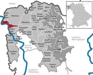
| Location of the municipality of Karlstein a.Main in the Aschaffenburg district | ||
  |
||


Karlstein am Main (officially Karlstein a.Main ) is a municipality in the Lower Franconian district of Aschaffenburg in Bavaria .
geography
Geographical location
The community is located in the lower Main valley, between the Hahnenkammhöhenzug and the Main , on the right bank. The westernmost point of the district of Aschaffenburg and the state of Bavaria is located in the district of Großwelzheim . The topographically highest point of the community is located approx. 800 m northwest of Sternberg at 332 m above sea level. NN (location) , the lowest is in the Main at 101.7 m above sea level. NN (location) .
Karlstein am Main is located around 30 kilometers southeast of Frankfurt am Main and is part of the Frankfurt Rhine-Main metropolitan region .
Community structure
The community consists of the districts Dettingen am Main (4,328 inhabitants) and Großwelzheim (4,322 inhabitants) (as of 2010).
Neighboring communities
| Municipality of Kahl am Main |
City of Alzenau |
|
| City of Seligenstadt |
.svg)
|
Johannesberg parish |
| Community Mainhausen | Community Kleinostheim |
Lakes
There are some lakes in the district of Karlstein am Main:
- Gustavsee (district Großwelzheim)
- Langer See (district Großwelzheim)
- Großwelzheimer bathing lake (district Großwelzheim)
etymology

According to anecdotal tradition, the name “Karlstein” goes back to Emperor Charlemagne . He was often in the Seligenstadt monastery directly opposite Karlstein and liked to go hunting in the Spessart . To get there, he crossed the Main to the place called "Tettingen" at the time. The stone at the landing stage or the boundary stone between "Tettingen" and "Walinesheim" was then called "Karlsteyn". The addition "on the Main" distinguishes Karlstein from other places of the same name.
history
19th and 20th centuries
In the course of the administrative reforms in Bavaria, the municipal edict of 1818 created the municipalities of Großwelzheim and Dettingen am Main.
On July 1, 1862, the Alzenau District Office was formed, on whose administrative territory the two communities were located. In 1939, as everywhere in the German Reich, the designation district was introduced. Großwelzheim and Dettingen now belonged to the 42 communities in the Alzenau district in Lower Franconia . With the dissolution of the Alzenau district on July 1, 1972, the two communities came to the newly formed Aschaffenburg district .
Incorporations
In the course of the regional reform in Bavaria , the two communities Großwelzheim and Dettingen were merged on July 1, 1975. In a vote, the community citizens decided on the name Karlstein , which appears in a description of the Aschaffenburg forest district as early as 1000, and a border marker on the former boundary between Dettingen and Großwelzheim. The first full-time mayor of the newly formed municipality was Richard Fuchs (1922–2016), who until his retirement in 1987 managed to merge the two formerly independent municipalities into an economically and culturally flourishing unit.
Nuclear power plants
A number of nuclear power plants were located in what is now the municipality of Karlstein .
politics
Municipal council
The local council of Karlstein am Main has 20 members (excluding the mayor).
| CSU | SPD | GREEN | FDP | total | |
| 2008 | 13 | 5 | 1 | 1 | 20 seats |
| 2014 | 11 | 6th | 2 | 1 | 20 seats |
(Status: municipal elections in Bavaria 2014 )
mayor
Peter Kreß (FDP) has been the mayor since July 2, 2017, before Winfried Bruder (CSU) was the mayor, he was confirmed in office in 2011.
coat of arms
Blazon
Wavy divided by blue and silver; The silver Dettinger cross at the top, a blue atomic symbol with a red core at the bottom .
Coat of arms history
The wave-like division of the coat of arms refers to the geographic location of the municipality on the Main, which is also part of the municipality name. The village was formed in 1975 from the formerly independent communities Dettingen and Großwelzheim. The coat of arms therefore contains parts of the former municipal coats of arms of these districts. The peculiarly designed cross in the upper part of the coat of arms is the " Dettinger Kreuz ", this refers to the sign of Charlemagne , only in the rhombus of the emperor there is a "T" for Tettingen , the earlier spelling of Dettingen, instead of its completion line . It dates from the late Gothic period and is located in the St. Hippolyt church in the Dettingen district. The atom symbol in the lower part of the coat of arms is taken from the coat of arms of the former community of Großwelzheim. The first German nuclear power plant was built as a test power plant in its municipality. After completion, electricity was fed into the power grid from 1961. The reactor was shut down in 1985 and completely dismantled by the end of 2010.
Coat of arms since October 13, 1977
Culture and sights
Architectural monuments
Natural monuments
Economy and Infrastructure
The Karlstein train station is Dettingen (Main) on the Main-Spessart-Bahn . In Dettingen, a pedestrian and cyclist bridge connects the north and south banks of the Main. There is a bus connection to the VAB . The Großwelzheim dam on the Main was dismantled between 1963 and 1973 and replaced by the new dam in Kleinostheim.
In Karlstein there is a research and development site of Areva NP , a company in the nuclear industry, and BMZ , a company that manufactures battery systems for automobiles, tools and other applications.
Schools and kindergartens
In Großwelzheim there was a state secondary school (Waldschule Großwelzheim, An der Waldschule) with a gym and in Dettingen there was a state elementary school (Grundschule Karlstein, Schulstraße 30) with lunchtime supervision, homework help, swimming pool and gym. There are also three kindergartens / day-care centers: The “Klabauterschiff” (state day-care center and day-care center, Eichendorffsstraße 25), the “Regenbogenland” (state day-care center and day-care center, Hörsteiner Straße 5) and the “Villa Kunterbunt” (Catholic kindergarten, Berliner Straße 12).
Personalities
- Konrad Wilhelm von Wernau (1638–1684), born in Dettingen, Prince-Bishop of the Würzburg Monastery
- Willibald Wex (1831-1892), landscape painter
- Rudolf Wöhrl (* 1913 in the district of Dettingen; † 2010 in Nuremberg ), entrepreneur
- Heinz Heuser (* 1928 in the Dettingen part of the municipality), wrestler
- Joachim Lorenz (* 1956 in the district of Dettingen), mineral collector and specialist in the Spessart and its minerals
- Alexander Leipold (* 1969), wrestler
- Elias Huth (* 1997 in the Großwelzheim district), soccer player
Web links
- Website of the municipality of Karlstein am Main
- Tour through the parish church of St. Peter and Paul in Dettingen
- Entry on the coat of arms of Karlstein am Main in the database of the House of Bavarian History
Individual evidence
- ↑ "Data 2" sheet, Statistical Report A1200C 202041 Population of the municipalities, districts and administrative districts 1st quarter 2020 (population based on the 2011 census) ( help ).
- ^ Journal of the Bavarian Surveying Administration (PDF; 753 kB)
- ↑ http://www.bayerische-landesbibliothek-online.de/orte/ortssuche_action.html ? Anzeige=voll&modus=automat&tempus=+20111121/235204&attr=OBJ&val= 1531
- ^ Wolf-Armin von Reitzenstein : Lexicon of Franconian place names. Origin and meaning . Upper Franconia, Middle Franconia, Lower Franconia. CH Beck, Munich 2009, ISBN 978-3-406-59131-0 , p. 115 ( limited preview in Google Book search).
- ^ Federal Statistical Office (ed.): Historical municipality directory for the Federal Republic of Germany. Name, border and key number changes in municipalities, counties and administrative districts from May 27, 1970 to December 31, 1982 . W. Kohlhammer GmbH, Stuttgart / Mainz 1983, ISBN 3-17-003263-1 , p. 736 .
- ↑ http://www.landkreis-aschaffenburg.de/landkreis/wahlen/kommunalwahl14/kreistagswahl/
- ↑ http://www.wahlen.bayern.de/kommunalwahlen/
- ↑ Wasser- und Schifffahrtsamt Aschaffenburg (WSA): On the history of the Main waterway ( memento of the original from June 7, 2015 in the Internet Archive ) Info: The archive link was automatically inserted and not yet checked. Please check the original and archive link according to the instructions and then remove this notice.
- ↑ Archived copy ( Memento of the original from December 17, 2013 in the Internet Archive ) Info: The archive link was inserted automatically and has not yet been checked. Please check the original and archive link according to the instructions and then remove this notice.
- ↑ Archived copy ( memento of the original dated December 23, 2015 in the Internet Archive ) Info: The archive link was inserted automatically and has not yet been checked. Please check the original and archive link according to the instructions and then remove this notice.
- ↑ http://www.gs-karlstein.de/schule/profil.htm
- ↑ Archived copy ( Memento of the original from March 4, 2016 in the Internet Archive ) Info: The archive link was inserted automatically and has not yet been checked. Please check the original and archive link according to the instructions and then remove this notice.
- ↑ http://www.villa-kunterbunt-karlstein.de/

Alzenau | Bessenbach | Blankenbach | Dammbach | Geiselbach | Glattbach | Goldbach | Großostheim | Haibach | Heigenbrücken | Heimbuchenthal | Heinrichsthal | Hösbach | Johannesberg | Kahl am Main | Karlstein am Main | Small bald | Kleinostheim | Krombach | Laufach | Mainaschaff | Mespelbrunn | Mömbris | Rothenbuch | Sailauf | Schöllkrippen | Summer bald | Stockstadt am Main | Waldaschaff | Weibersbrunn | Western reason | grasslands
Unregulated areas: Forst Hain i.Spessart |
Heinrichsthaler Forst |
Rohrbrunner Forest |
Rothenbuch Forest |
Sailauf Forest |
Schöllkrippen Forest |
Waldaschaffer Forest |
Wiesen forest