
Sailauf
| coat of arms | Germany map | |
|---|---|---|

|
Coordinates: 50 ° 1 ′ N , 9 ° 15 ′ E |
|
| Basic data | ||
| State : | Bavaria | |
| Administrative region : | Lower Franconia | |
| County : | Aschaffenburg | |
| Height : | 177 m above sea level NHN | |
| Area : | 13.82 km 2 | |
| Residents: | 3596 (Dec. 31, 2019) | |
| Population density : | 260 inhabitants per km 2 | |
| Postcodes : | 63877, 63846 | |
| Primaries : | 06024, 06093 | |
| License plate : | AB , ALZ | |
| Community key : | 09 6 71 150 | |
| LOCODE : | DE SIF | |
| Community structure: | 3 districts | |
| Address of the municipal administration: |
Rathausstrasse 9 63877 Sailauf |
|
| Website : | ||
| Mayor : | Michael Dümig ( SPD ) | |
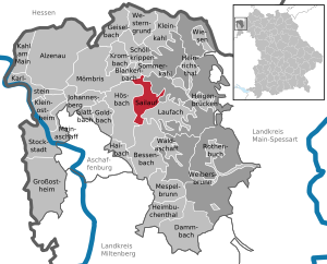
| Location of the community Sailauf in the district of Aschaffenburg | ||
  |
||


Sailauf is a municipality in the Lower Franconian district of Aschaffenburg . The place is in the Vorspessart near Aschaffenburg and is one of the oldest settlements there.
geography
The topographically highest point of the municipality is the summit of the Bischlingsberg southeast of Sailauf at 375 m above sea level. NN (location) , the lowest is on the Aschaff southwest of the Weiberhof at 145 m above sea level. NN (location) .
Community structure
Sailauf has three districts (the number of residents in brackets) in two districts :
- Oak Mountain (788)
- Sailauf (2861)
To the northeast of Sailauf are 19 small exclaves in the municipality in the area of the Sailaufbach spring.
The former districts of Obersailauf , Mittelailauf and Untersailauf are now structurally grown together and form the district of Sailauf.
Neighboring communities
| Community Blankenbach |
Community Sommerkahl |
|
| Market Hösbach |
.svg)
|
Sailaufer Forst (municipality-free area) |
| Community Bessenbach |
community Laufach |
Surname
etymology
It is not known exactly what the name Sailauf is derived from. There are two possible theories:
- The name of the settlement is based on the old personal name Sigelouf .
- The name comes from the Sailauf brook , which flows into the Laufach municipality . Since this stream of the same name exists and place names often developed from water names in the region, this etymology is more likely.
Earlier spellings
Earlier spellings of the place from various historical maps and documents:
|
|
history
The early church of the upper Aschaff Valley was already there in 1089 . The Sigilovf (e) manor was first mentioned in a document in 1189 , from which the name Sailauf developed. In the 13th century, Sailauf was temporarily under the rule of the Counts of Rieneck , who built the "Landesere" castle on the nearby Graefenberg . In 1265, the Elector of Mainz, Werner von Eppstein, built the hunting lodge “castrum vivarium”, which was later renamed “Weyberhof”. When the plague raged in Europe in 1349 , the Vorspessart was almost deserted. Later settlers from the Steigerwald came to Sailauf . In 1552 the “ Weyberhöfe ” castle was destroyed in the Second Markgrafler War.
In the Thirty Years War (1618-1648) Sailauf was almost completely destroyed. In 1789 the Sankt-Vitus-Kirche was built over Sailauf, which is probably the fourth church on this site. In 1803 the reign of the Elector of Mainz ended in the Vorspessart, and in 1814 Aschaffenburg and the surrounding area came to Bavaria.
On July 1, 1862, the district office of Aschaffenburg was formed, on whose administrative area Sailauf was located. In 1939, as everywhere in the German Reich, the designation district was introduced. Sailauf was now one of the 33 communities in the old district of Aschaffenburg . On July 1, 1972, this merged with the Alzenau district in Lower Franconia to form the new Aschaffenburg district.
Eichenberg has belonged to Sailauf since July 1, 1972.

Inside Weyberhöfe Castle
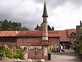
Entrance area of the castle

The striking south wing of the castle with the Mainz coat of arms


politics
Municipal council
The municipal council has 16 members. Another member and chairman of the municipal council is the mayor. In the local elections on March 15, 2020, 1,843 of the 2,926 residents entitled to vote in the municipality of Sailauf exercised their right to vote, bringing the turnout to 62.99%.
mayor
In the local elections on March 15, 2020, Michael Dümig (SPD) was re-elected with 85.45% of the vote. He has been in office since May 1, 2008.
coat of arms
Blazon
A red inclined left bar in silver, covered with a six-spoke silver wheel; above a blue oblique left-hand wave bar, below a slanted green oak branch.
Coat of arms history
The blue oblique left-hand wave bar represents the location of the community at the confluence of the Sailauf and Steinbach rivers . The green oak branch indicates the oak-rich Spessart in which the municipality is located. From the middle of the 13th century until 1803 the place belonged to the Kurstaat Mainz, which is indicated in the coat of arms by the silver wheel (" Mainzer Rad ") and the red oblique left bar. The colors red and silver are the colors of the spa state. The coat of arms was awarded on March 21, 1969.
Culture and sights
Sights / surroundings

.jpg)
- The late Baroque St. Vitus Church (1789) on a hill probably goes back to three previous buildings (see above). St. Vitus was the mother parish for 10 settlements in the area. From the Romanesque first building (11th century), the tower and a mask console below the helmet, the so-called Bleckmaul, have been preserved . On the south facade there is a crucifixion group below the outer fresco of a protective mantle Madonna. The interior is from the 18th century.
- The core of the cemetery also goes back to the medieval complex. The baroque entrance portal is decorated with sculptures of the church patron Vitus, the mother of God Mary and the plague saint Sebastian .
- The structure of the lower town is historically younger. Today's half-timbered town hall (since 1938) was built around 1800 (originally forester's apartment, bakery and grocery store). The small onion dome with tower clock is an ingredient from 1940. In front of the town hall there is a weathered wayside shrine with a pietà .
- The schoolhouse (brick building) dates from 1906.
- Above the church, cycling and hiking trails lead to a nature trail through the orchards . The Sailauf pastor Bonaventura Ruf was an active promoter of the local apple and quince cultivation, which was an important branch of the community's economy until the 1950s. With the global fruit import since the 1960s, the orchard areas have gradually declined. The hiking trail leads past the Hofwiesenteiche (fishing pond), the Sämenhof (Aussiedlerhof with restaurant) and the Rottenberg chapel and thus connects Rottenberg , Eichenberg , the Sailaufer Forst and the Englander .
Architectural monuments
Soil monuments
The Hartkoppe
The Hartkoppe (also called Fuchs quarry) is a rhyolite quarry that is still in operation near the village of Sailauf and is now a well-known site among mineral collectors for some rare minerals, including uranyl minerals, or the sailaufite named after this type of locality . The okrushite was also found and described for the first time in this quarry.
Social

There is a diverse club life in Sailauf, and the juniors from the Bavarian Red Cross are also known and successful across the region .
Two special features of Sailaufs are the annual Sailauf Knoblauchfest and the Tsukahara Festival.
There are two kindergartens and one elementary school at social institutions. The community is affiliated with the Association of Local Music Schools .
Sailauf became known nationwide in 2009 when the Church of the Resurrection, consecrated in 1971, was demolished against the protests of the faithful and citizens at the instigation of the Diocese of Würzburg . The church was an exposed concrete building based on a design by the architect Emil Mai. The building was considered a monument by the Bavarian State Office for Monument Preservation. A profane reuse of the church, advocated by the citizens, was rejected by the Catholic Church and the majority did not support the political community.
Economy and Infrastructure
traffic
- Sailauf has a connection to the A 3 , B 26
- The Spessart-Höhenstraße leads through Sailauf .
- The district roads AB 2 , AB 12 and AB 24 lead through Sailauf
Established businesses
Sailauf is the European development location of the Electronic division of the international automotive supplier group Magna International Inc.
Educational institutions
Sailauf has its own elementary school and three kindergartens , two of which are church-sponsored.
Personalities
- Theodor Bergmann (1850–1931), entrepreneur and automobile manufacturer
- Bernhard Lippert (* 1962), football coach
- Ambros Neuburger (1925–2002), politician
literature
- Rudolf J. Lippert: Sailauf and Eichenberg in the light of tradition. Self-published, Obertshausen 2003
- Werner Konrad, Ferdl Kraus, Waldemar Lippert: Sailauf-Eichenberg. In pictures from the turn of the millennium , Geiger-Verlag 2000
- Sailauf Eichenberg. Pictures from over 100 years of the village past , by Ferdinand Kraus (foreword), Fred Maier (foreword), Karl Strom (foreword), Gerhard Steigerwald (foreword), Maria Reinhardt, Herta Hubertus, Bruno Eisert, Gottfried Baumann, Geiger-Verlag 1996
- Peter Wohlwender (Ed.): Church of Resurrection in Sailauf , Dreiviertelhaus Publishing House, Berlin 2019
- Thomas Eisert: " Sailauf School Lessons" - publisher: Förderverein Sailauf für Heimat und Geschichte e. V. in April 2020
Web links
- Entry on the coat of arms of Sailauf in the database of the House of Bavarian History
- Structural change in Sailauf 1939 to 1969 with a view
- Structural data 1998
- Sailauf: Official statistics of the LfStat
Individual evidence
- ↑ "Data 2" sheet, Statistical Report A1200C 202041 Population of the municipalities, districts and administrative districts 1st quarter 2020 (population based on the 2011 census) ( help ).
- ^ Resident Sailauf (as of May 17, 2013)
- ↑ Bavarian State Library Online. Retrieved February 10, 2015 .
- ↑ a b c Wolf-Armin von Reitzenstein : Lexicon of Franconian place names. Origin and meaning . Upper Franconia, Middle Franconia, Lower Franconia. CH Beck, Munich 2009, ISBN 978-3-406-59131-0 , p. 196 ( limited preview in Google Book search).
- ^ Wilhelm Volkert (ed.): Handbook of Bavarian offices, communities and courts 1799–1980 . CH Beck, Munich 1983, ISBN 3-406-09669-7 , p. 422 .
- ↑ Results of local elections 2020. OK.VOTE, March 15, 2020, accessed on May 19, 2020 .
- ↑ Results of local elections 2020. OK.VOTE, March 15, 2020, accessed on May 19, 2020 .
- ↑ Results of local elections 2020. OK.VOTE, March 15, 2020, accessed on May 19, 2020 .
- ↑ The Fuchs quarry on Hartkoppe near Sailauf. Retrieved February 10, 2015 .
- ↑ Sailaufit. Retrieved February 10, 2015 .
- ↑ The rhyolite from Hartkoppe near Sailauf in the Spessart and its diverse and rare minerals. Retrieved February 10, 2015 .
- ↑ Okruschite, Ca2Mn2 +. Retrieved February 10, 2015 .

Alzenau | Bessenbach | Blankenbach | Dammbach | Geiselbach | Glattbach | Goldbach | Großostheim | Haibach | Heigenbrücken | Heimbuchenthal | Heinrichsthal | Hösbach | Johannesberg | Kahl am Main | Karlstein am Main | Small bald | Kleinostheim | Krombach | Laufach | Mainaschaff | Mespelbrunn | Mömbris | Rothenbuch | Sailauf | Schöllkrippen | Summer bald | Stockstadt am Main | Waldaschaff | Weibersbrunn | Western reason | grasslands
Unregulated areas: Forst Hain i.Spessart |
Heinrichsthaler Forst |
Rohrbrunner Forest |
Rothenbuch Forest |
Sailauf Forest |
Schöllkrippen Forest |
Waldaschaffer Forest |
Wiesen forest