Dammbach
| coat of arms | Germany map | |
|---|---|---|

|
Coordinates: 49 ° 52 ' N , 9 ° 20' E |
|
| Basic data | ||
| State : | Bavaria | |
| Administrative region : | Lower Franconia | |
| County : | Aschaffenburg | |
| Management Community : | Mespelbrunn | |
| Height : | 269 m above sea level NHN | |
| Area : | 32.93 km 2 | |
| Residents: | 1875 (Dec. 31, 2019) | |
| Population density : | 57 inhabitants per km 2 | |
| Postcodes : | 63874, 63863 | |
| Area code : | 06092 | |
| License plate : | AB , ALZ | |
| Community key : | 09 6 71 160 | |
| Community structure: | 8 districts | |
| Association administration address: | Hauptstrasse 81 63872 Heimbuchenthal |
|
| Website : | ||
| First Mayor : | Waltraud Amrhein (Independent Voting Group) | |
| Location of the community of Dammbach in the district of Aschaffenburg | ||

Dammbach is a municipality in the Lower Franconian district of Aschaffenburg and a member of the Mespelbrunn administrative community based in Heimbuchenthal .
geography
Geographical location
The community is located in the center of the Spessart , in the so-called Hochspessart. The community of Dammbach is known for its many hamlets , such as the Schnorrhof, the Hundsrück, the Heppe or Oberwintersbach ( Geishöhe ).
The Dammbach rises near Rohrbrunn and has many small tributaries. The topographically highest point of the municipality is at about 566 m above sea level. NHN (location) east of Krausenbach near the summit of the Querberges , the lowest is on Neuhammer am Dammbach at 191 m above sea level. NN (location) .
Community structure
There are eight districts in two districts :
In recent years, the community of Dammbach has designated a weekend area near the Wintersbach district in which more than 100 weekend and holiday homes have been built.
Markings
- Krausenbach
- Wintersbach
The former community-free area Krausenbacher Forst was incorporated into Dammbach in 2008.
Neighboring communities
| Community Heimbuchenthal |
Rohrbrunner Forst (municipality-free area) |
|

|
||
| Eschau market |
Community Altenbuch |
Surname
The place name comes from the dam stream of the same name , which flows into the Elsava at Neuhammer .
history
20th century
In 1991 the community was able to celebrate the festival "750 years of villages in the Dammbachtal", for which the community published the home book "Dammbach 1241-1991".
Incorporations
The municipality was created on June 1, 1976 as part of the municipal reorganization in Bavaria from the previously independent municipalities of Wintersbach and Krausenbach . Since both districts are located in the Dammbachtal, it made sense to choose Dammbach as the common place name. On January 1, 2008, the community area expanded through the incorporation of the Krausenbacher Forest .
politics
Municipal council
After the last local election on March 16, 2014, the local council has twelve members. The turnout was 71.43%. The choice brought the following result:
| CSU / Free Voting Community | 6 seats | (48.89%) | |
| Impartial group of voters | 6 seats | (51.11%) |
Mayoress
Waltraud Amrhein (UWG) has been mayor since May 2020; It was elected on March 15, 2020 with 52.1% of the valid votes. Her predecessor was Roland Bauer (CSU / Free Voting Association), in office from May 2002 to April 2020.
coat of arms
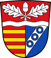
| Blazon : "Divided by a raised silver wavy bar: above in red two diagonally crossed silver oak leaves and a silver acorn, split at the bottom, divided seven times in front by red and gold, behind in blue a silver oblique left-hand bar with three blue rings." | |
Coat of arms history
The community was created in 1976 from the formerly independent communities Krausenbach and Winterbach through a voluntary merger. It is geographically located on the Dammbach, from which the place name is derived. The wave beam in the coat of arms indicates the brook. The oak leaves and the acorn in the head of the shield are symbols for the location of the municipality in the Hochspessart. The sevenfold division of gold and red is taken from the coat of arms of the Counts of Rieneck. Krausenbach was in their possession for a long time. The silver sloping bar with the three blue rings is the coat of arms of the Echter von Mespelbrunn family. They ruled Wintersbach, built a church there around 1415 and a hospital in 1584.
The coat of arms was awarded on July 22, 1988.
Culture and sights
Passion play
Passion plays have been performed in Dammbach since 2001. There were further performances in 2004, 2009 and 2014.
Architectural monuments
On the outskirts of Dammbach-Krausenbach into the upper Dammbachtal, opposite the Untere Schnorrhof / Ferschenmühle restaurant in the meadow area facing the street, there is the underground monument Burgstall Unterschnorrhof (also called Herbroch Castle ).
Soil monuments
traffic
The PSA radio beacon for an international air route is located in Dammbach .
Others
Since December 1, 2006, the municipality has levied a second home tax.
Web links
Individual evidence
- ↑ "Data 2" sheet, Statistical Report A1200C 202041 Population of the municipalities, districts and administrative districts 1st quarter 2020 (population based on the 2011 census) ( help ).
- ↑ contact person. Municipality of Dammbach, accessed on June 5, 2020 .
- ↑ Map services of the Federal Agency for Nature Conservation ( information )
- ↑ http://www.bayerische-landesbibliothek-online.de/orte/ortssuche_action.html ? Anzeige=voll&modus=automat&tempus=+20111121/220103&attr=OBJ&val= 1558
- ^ Wolf-Armin von Reitzenstein : Lexicon of Franconian place names. Origin and meaning . Upper Franconia, Middle Franconia, Lower Franconia. CH Beck, Munich 2009, ISBN 978-3-406-59131-0 , p. 52 ( limited preview in Google Book search).
- ^ Federal Statistical Office (ed.): Historical municipality directory for the Federal Republic of Germany. Name, border and key number changes in municipalities, counties and administrative districts from May 27, 1970 to December 31, 1982 . W. Kohlhammer GmbH, Stuttgart / Mainz 1983, ISBN 3-17-003263-1 , p. 736 .
- ^ Election of the first mayor
- ^ Entry on the coat of arms of Dammbach in the database of the House of Bavarian History
- ↑ http://www.passionsspiele-dammbach.de/entstehung.html History of the creation of the Dammbach Passion Play


