Geisheight
| Geisheight | ||
|---|---|---|
|
Transmitter on the Geißhöhe |
||
| height | 521 m above sea level NN | |
| location | District of Aschaffenburg , Bavaria ( Germany ) | |
| Mountains | Spessart | |
| Dominance | 5.3 km → Querberg | |
| Notch height | 109 m ↓ N of Hundsrück | |
| Coordinates | 49 ° 50 '28 " N , 9 ° 19' 19" E | |
|
|
||
The Geishöhe or Geißhöhe is 521 m above sea level. NHN high mountain in the Spessart in the Bavarian district of Aschaffenburg .
description
The Geishöhe lies between the towns of Wintersbach and Wildensee . The hamlet of Oberwintersbach is on its summit . In the north the Geishöhe is limited by the valley of the Dammbach . In the south the Agneshöhe (513 m) is flat . The Rosselbrunngraben rises on its western slopes .
Ludwig Keller Tower
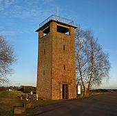
60 meters west of the summit of the Geißhöhe stands the Ludwig-Keller-Turm, which was built by the Spessart Association in 1936/37 and named after a former chairman of the Spessart Association and inaugurated on September 5, 1937, at a height of around 518.5 m . The 13 m high observation tower has two platforms, of which the lower one is accessible via 47, the upper one via a further 13 steps. From here there is a wide panoramic view of Spessart , Odenwald , Taunus and Rhön . On the 11.9 m high upper platform, next to an orientation board, there is a post with a geodetic reference point for the Bavarian Surveying Administration ( 531.52 m above sea level ).
The tower was completely renovated in 2003. It is named after the high school professor and former chairman of the Spessart Association, Ludwig Keller (1873–1932).
Due to its exposed location, the observation tower is regularly used by radio amateurs for a limited period as a transmission and reception tower for international amateur radio competitions. A 35 m high steel lattice mast rises 100 meters east of the Ludwig-Keller-Turm, which carries the antennas of the Geißhöhe receiving and transmitting system.
Four marked hiking routes of the Spessartbund meet at the Ludwig-Keller-Turm.
See also
Web links
Individual evidence
- ↑ Geodetic reference point Dammbach on the website of the Bavarian State Office for Digitization, Broadband and Surveying


