
Administrative community Mespelbrunn
| coat of arms | Germany map | |
|---|---|---|
 Help on coat of arms |
Coordinates: 49 ° 55 ' N , 9 ° 18' E |
|
| Basic data | ||
| Existing period: | 1978– | |
| State : | Bavaria | |
| Administrative region : | Lower Franconia | |
| County : | Aschaffenburg | |
| Area : | 65.61 km 2 | |
| Residents: | 6249 (Dec. 31, 2019) | |
| Population density : | 95 inhabitants per km 2 | |
| License plate : | AB , ALZ | |
| Association key : | 09 6 71 5603 | |
| Association structure: | 3 municipalities | |
| Association administration address : |
Main street 81 63872 Heimbuchenthal |
|
| Website : | ||
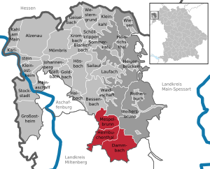
| Location of the administrative community Mespelbrunn in the district of Aschaffenburg | ||
  |
||

In the administrative community of Mespelbrunn in the Lower Franconian district of Aschaffenburg , the following communities have come together to handle their administrative business:
- Heimbuchenthal , 2180 inhabitants, 17.15 km²
- Mespelbrunn , 2194 inhabitants, 15.53 km²
- Dammbach , population 1875, 32.93 km²
The administrative community was founded on May 1st, 1978.
The seat of the administrative association is Heimbuchenthal.
Individual evidence
- ↑ "Data 2" sheet, Statistical Report A1200C 202041 Population of the municipalities, districts and administrative districts 1st quarter 2020 (population based on the 2011 census) ( help ).
Administrative communities in the Aschaffenburg district
Heigenbrücken | Mespelbrunn | Schöllkrippen
Dissolved: Rauenthal | Waldaschaff