
Bessenbach
| coat of arms | Germany map | |
|---|---|---|

|
Coordinates: 49 ° 57 ' N , 9 ° 15' E |
|
| Basic data | ||
| State : | Bavaria | |
| Administrative region : | Lower Franconia | |
| County : | Aschaffenburg | |
| Height : | 229 m above sea level NHN | |
| Area : | 29.98 km 2 | |
| Residents: | 5658 (Dec. 31, 2019) | |
| Population density : | 189 inhabitants per km 2 | |
| Postal code : | 63856 | |
| Area code : | 06095 | |
| License plate : | AB , ALZ | |
| Community key : | 09 6 71 112 | |
| Community structure: | 10 districts | |
| Address of the municipal administration: |
Ludwig-Straub-Strasse 2 63856 Bessenbach |
|
| Website : | ||
| First Mayor : | Christoph Ruppert (CSU) | |
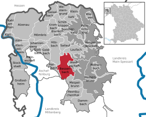
| Location of the community of Bessenbach in the district of Aschaffenburg | ||
  |
||


Bessenbach is a municipality in the Lower Franconian district of Aschaffenburg and is located southeast of the city of Aschaffenburg between the foothills of the Spessart .
geography
The topographically highest point of the municipality is the summit of the Salzbuckel east of Waldmichelbach at 464 m above sea level. NN (location) , the lowest is on the Aschaff east of Hösbach train station at 151 m above sea level. NN (location) .
geology
About half of the community consists of forest. Beech and oak grow best in this forest .
Since 1996 there has been a forest work group between the Hösbach market and the communities of Bessenbach, Laufach and Sailauf .
Community structure
There are ten districts (in brackets the number of residents including second home) in three districts :
|
|
The former place Mittelbessenbach is today structurally fused with Keilberg.
The following districts are geographically independent, but are not listed as official districts:
- Beetacker (industrial area)
- Community center
Markings
- Wedge Mountain
- Oberbessenbach
- Straßbessenbach
Neighboring communities
| Market Hösbach |
Sailauf parish |
Municipality of Laufach and Forst Hain in Spessart (municipality-free area) |
| City of Aschaffenburg and the community of Haibach |
.svg)
|
Municipality of Waldaschaff and Waldaschaffer Forst (municipality-free area) |
| Market Sulzbach |
Forst Hohe Wart (municipality-free area) |
community Mespelbrunn |
history
Etymology and earlier spellings
Bessenbach takes its name from the Bessenbach of the same name , which flows through the municipality and flows into the Aschaff .
The earlier spellings of the places Unterbessenbach, Mittelbessenbach, Straßbessenbach and Oberbessenbach from various historical maps and documents:
|
|
|
|
Merger and incorporations
The community was formed on January 1, 1972 through the merger of the communities Keilberg and Straßbessenbach . On January 1, 1978, the municipality of Oberbessenbach was added.
religion
Catholic Churches:
politics
- CSU : 10
- BBL : 10
Municipal council
The municipal council has 20 members. Another member and chairman of the municipal council is the mayor. In the local elections on March 15, 2020, 2,954 of the 4,524 residents eligible to vote in the municipality of Bessenbach exercised their right to vote, bringing the turnout to 65.30%.
mayor
On March 15, 2020, Christoph Ruppert (CSU) was elected first mayor for the first time with 90.52% of the vote. His predecessor was Franz Straub (CSU) from May 2002 to April 2020.
Town twinning
-
 France : The municipality of Bessenbach has had a partnership with the municipalities of Dury , Saint-Fuscien and Sains-en-Amiénois since 1985.
coat of arms
|
|
Blazon : "In blue over a lowered silver wave bar, a red-armored silver stork with two heads" |
Coat of arms history: The formerly independent municipalities of Keilberg , Straßbessenbach and Oberbessenbach merged into one municipality in 1978 and took on the historical name of Bessenbach again. The local noble family of the same name was decisive for the development of the area of today's municipality of Bessenbach. His ancestral castle was in today's part of the municipality Keilberg. The sex is documented in the 12th century; it had rulership and judicial rights in the entire Bessenbachtal, which it sold in the late 13th century. The family coat of arms - the double-headed stork - was therefore included in the municipal coat of arms. For the Bessenbach as a geographically connecting element of the municipality of the same name, the silver wave bar appears in the municipality's coat of arms.
Coat of arms since: November 28, 1977.
Architectural monuments
Soil monuments
Economy and Infrastructure
traffic
- The community is served from the main station in Aschaffenburg by various bus lines of the Verkehrsgemeinschaft am Bayerischen Untermain.
- In addition, Bessenbach is located directly at the motorway exit of the federal motorway 3 Bessenbach / Waldaschaff and near the Spessart service area near Rohrbrunn.
In this context, Bessenbach, together with Aschaffenburg, has achieved a certain level of awareness, especially due to the very frequent traffic jams on the A3.
education
- State secondary school Bessenbach
- Elementary school Bessenbach
Others
Sons and daughters of the church
- Hans Dietrich von Gemmingen (1869–1958), royal Bavarian chamberlain
literature
- Luise Braun: Oberbessenbach - My home village yesterday and today. Norderstedt 2010.
Web links
Individual evidence
- ↑ "Data 2" sheet, Statistical Report A1200C 202041 Population of the municipalities, districts and administrative districts 1st quarter 2020 (population based on the 2011 census) ( help ).
- ↑ Greetings. Bessenbach municipality, accessed on May 30, 2020 .
- ↑ 2010 annual statistics of the community of Bessenbach
- ↑ bayerische-landesbibliothek-online.de
- ↑ a b Wolf-Armin von Reitzenstein : Lexicon of Franconian place names. Origin and meaning . Upper Franconia, Middle Franconia, Lower Franconia. CH Beck, Munich 2009, ISBN 978-3-406-59131-0 , p. 37 ( limited preview in Google Book search).
- ^ Wilhelm Volkert (ed.): Handbook of Bavarian offices, communities and courts 1799–1980 . CH Beck, Munich 1983, ISBN 3-406-09669-7 , p. 422 .
- ^ Federal Statistical Office (ed.): Historical municipality directory for the Federal Republic of Germany. Name, border and key number changes in municipalities, counties and administrative districts from May 27, 1970 to December 31, 1982 . W. Kohlhammer GmbH, Stuttgart / Mainz 1983, ISBN 3-17-003263-1 , p. 736 .
- ↑ Results of local elections 2020. OK.VOTE, March 15, 2020, accessed on May 18, 2020 .
- ↑ Results of local elections 2020. OK.VOTE, March 15, 2020, accessed on May 18, 2020 .
- ^ Entry on the coat of arms of Bessenbach in the database of the House of Bavarian History
- ^ Entry on the coat of arms of Bessenbach in the database of the House of Bavarian History

Alzenau | Bessenbach | Blankenbach | Dammbach | Geiselbach | Glattbach | Goldbach | Großostheim | Haibach | Heigenbrücken | Heimbuchenthal | Heinrichsthal | Hösbach | Johannesberg | Kahl am Main | Karlstein am Main | Small bald | Kleinostheim | Krombach | Laufach | Mainaschaff | Mespelbrunn | Mömbris | Rothenbuch | Sailauf | Schöllkrippen | Summer bald | Stockstadt am Main | Waldaschaff | Weibersbrunn | Western reason | grasslands
Unregulated areas: Forst Hain i.Spessart |
Heinrichsthaler Forst |
Rohrbrunner Forest |
Rothenbuch Forest |
Sailauf Forest |
Schöllkrippen Forest |
Waldaschaffer Forest |
Wiesen forest
Keilberg with Frauengrund , Steiger , Unterbessenbach , Waldmichelbach and Weiler | Oberbessenbach | Straßbessenbach with Klingerhof and Klingermühle