
Mainhausen
| coat of arms | Germany map | |
|---|---|---|

|
Coordinates: 50 ° 1 ′ N , 8 ° 59 ′ E |
|
| Basic data | ||
| State : | Hesse | |
| Administrative region : | Darmstadt | |
| County : | Offenbach | |
| Height : | 112 m above sea level NHN | |
| Area : | 17.92 km 2 | |
| Residents: | 9364 (Dec. 31, 2019) | |
| Population density : | 523 inhabitants per km 2 | |
| Postal code : | 63533 | |
| Area code : | 06182 | |
| License plate : | OF | |
| Community key : | 06 4 38 007 | |
| LOCODE : | DE MHN | |
| Community structure: | 2 districts | |
| Address of the municipal administration: |
Rheinstrasse 3 63533 Mainhausen |
|
| Website : | ||
| Mayoress : | Ruth Disser ( SPD ) | |
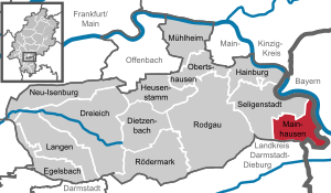
| Location of the community of Mainhausen in the Offenbach district | ||
  |
||

With around 9,000 inhabitants, Mainhausen is the smallest municipality in the Offenbach district in Hesse .
geography
Geographical location
Mainhausen is one of 13 cities and communities in the Offenbach district and is located in the southernmost part of Hesse, right on the border with the Free State of Bavaria . The community is located on the eastern edge of the Rhine-Main area directly on the Main and southeast of the metropolis of Frankfurt am Main .
Expansion of the urban area
The municipal area extends over 17.92 km².
Neighboring communities and districts
Mainhausen borders the city of Seligenstadt in the west and north , the communities Karlstein , Kleinostheim and Stockstadt am Main (all three districts of Aschaffenburg ) in the east and the city of Babenhausen ( district of Darmstadt-Dieburg ) in the south .
Community structure
Mainhausen consists of the localities and districts Mainflingen in the northeast and Zellhausen in the southwest.
history
The history of the individual districts is presented in the respective district articles.
In the Middle Ages, the village of Hausen (Husen) existed near Mainflingen , which is mentioned around 1357 as an imperial knighthood fief of Hanau. The houses castle is an old tower hill from the 10th or 11th century by an unknown builder.
The municipality of Mainhausen was created in the course of the regional reform in Hesse by law on January 1, 1977 through the merger of the previously independent municipalities and today's districts Mainflingen and Zellhausen . Local districts were not formed in the municipality of Mainhausen. The parish name is a trunk word from the names of the two earlier parishes.
politics
Community representation
The local elections on March 6, 2016 had the following results compared to previous local elections:
| Parties and constituencies | % 2016 |
Seats 2016 |
% 2011 |
Seats 2011 |
% 2006 |
Seats 2006 |
% 2001 |
Seats 2001 |
||
|---|---|---|---|---|---|---|---|---|---|---|
| SPD | Social Democratic Party of Germany | 53.8 | 15th | 57.6 | 16 | 45.4 | 14th | 40.8 | 13 | |
| CDU | Christian Democratic Union of Germany | 22.2 | 6th | 26.8 | 7th | 37.5 | 12 | 56.0 | 17th | |
| UWG | Independent voter community Mainhausen | 16.5 | 4th | 11.1 | 3 | 5.7 | 2 | - | - | |
| FDP | Free Democratic Party | 7.5 | 2 | 4.4 | 1 | 11.4 | 3 | 3.1 | 1 | |
| total | 100.0 | 27 | 100.0 | 27 | 100.0 | 31 | 100.0 | 31 | ||
| Voter turnout in% | 54.6 | 49.9 | 47.5 | 58.2 | ||||||

mayor
In the last mayoral election in 2009, Ruth Disser (SPD) prevailed with 66.9% of all votes. The turnout was 77.89%. In September 2015, Ms. Disser was re-elected for another term of office.
Town twinning
Mainhausen maintains partnerships with the municipality of Pöls in Austria and with the municipality of Schwerstedt (near Straussfurt) in the Sömmerda district in Thuringia .
badges and flags

coat of arms
Blazon : “In a square shield on the top right in red in a silver, rising horse, on the top left a red (Mainz) wheel on silver, on the bottom right a transmitter mast with three red transmission waves arranged in concentric circles on silver, on the bottom left a silver pine cone on red . "
The coat of arms of the municipality of Mainhausen was approved on March 1, 1982 by the Hessian Minister of the Interior . It was designed by Mainflinger designer and graphic artist Norbert Roth, it was designed by the Bad Nauheim heraldist Heinz Ritt .
The horse symbolizes the district of Mainflingen, whose inhabitants are called Maoflinger Schimmel . The pine cone comes from the coat of arms of the Zellhausen district, whose inhabitants worked as schoofplickers (cone breakers) in earlier centuries . The Mainz wheel shows the Mainz history of both districts, while the transmitter mast symbolizes the future or present of the community through the transmitter systems in Mainflingen .
flag
The flag was approved by the Hessian Interior Minister on December 28, 1982 and is described as follows:
"The municipal coat of arms is placed on the red / white flag web in the upper half."
Infrastructure
Large transmission systems for long and medium wave, see transmission systems in Mainflingen .
traffic
Landstrasse 3065 runs through the village and leads north to Landstrasse 2310. The L 2310 changes to the federal highway 469 east of the town at the Autobahn connection 48 of the Bundesautobahn 45 (junction Mainhausen) . In the southeast of the municipality is the Seligenstädter Dreieck , where the federal highway 45 connects to the federal highway 3 .
With Mainhausen-Zellhausen there is a stop on the Odenwaldbahn in Mainhausen (district Zellhausen) . It is served by the RB 64 / RE 64 line of the Rhein-Main transport association . The halt was put into operation as Zellhausen on October 1, 1908 , and in 1931 the staff was withdrawn and replaced by a railway agency .
natural reserve

The nature reserve Bong'sche Kiesgrube and Mainufer near Mainflingen (NSG identification 1438001) is located south of Mainflingen in a triangle between the district Mainflingen in the north, the federal autobahn 45 in the east and the state road 2310 in the south. It covers a lake area of around 94.52 hectares , which is located in the urban area of Mainhausen.
Clay mining began around 1920 on the site of what is now the nature reserve, and around 1933 the deposits were exhausted. In the early 1960s, gravel mining began in the area where the water is today. In 1976 the operation of the Bong grinder was stopped; the operation of the sand washing plant in the nature reserve and the clay mining in the Bong clay pit continued into the 1990s.
The protection purpose is to secure and preserve the former gravel pit and the adjacent bank areas of the Main as a supraregional important resting, wintering and breeding area for numerous water-bound and threatened bird species, but also as a habitat for endangered amphibians and insects and near-natural floodplain vegetation.

The former clay pit of Mainhausen nature reserve (NSG identification 1438034) is located south of Mainflingen in a triangle between the Mainflingen district in the north, the A 45 in the east and the L 2310 in the south. It covers an area of around 15.59 hectares of lakes, which is located in the urban area of Mainhausen.
The protection purpose is to secure and preserve the former gravel pit and the adjacent bank areas of the Main as a supraregional important resting, wintering and breeding area for numerous water-bound and threatened bird species, but also as a habitat for endangered amphibians and insects and near-natural floodplain vegetation. The main reason for the classification as a nature reserve was the settlement of the black-necked grebe in 1999. Since then, the species has had its most important and, in some years, only breeding population here in Hesse.

The Speckgraben nature reserve near Mainflingen (NSG identification 1438031) is located south of Mainflingen in a triangle between the Mainflingen district in the north, federal highway 469 and state road 2310 in the south. It covers 31.72 hectares of forest and lake area in the urban area of Mainhausen.
The purpose of the protection is to preserve wetlands and quarry forest communities in an old loop of the Main and to secure their natural connection to the Main. In particular, it is important to preserve rare and endangered large sedge beds and a large contiguous peat moss - birch - alder - quarry forest with their fauna and numerous endangered species.
Sons and daughters of the church
- Käthe Paulus (1868–1935), first German professional air skipper, aerial acrobat and inventor of the foldable parachute
Web links
- Website of the community of Mainhausen
- "Mainhausen, Offenbach District". Historical local dictionary for Hessen. In: Landesgeschichtliches Informationssystem Hessen (LAGIS).
- Literature about Mainhausen in the Hessian Bibliography
- Literature from and about Mainhausen in the catalog of the German National Library
- Link catalog on Mainhausen at curlie.org (formerly DMOZ )
Individual evidence
- ↑ Hessian State Statistical Office: Population status on December 31, 2019 (districts and urban districts as well as municipalities, population figures based on the 2011 census) ( help ).
- ↑ Law on the reorganization of the Offenbach district (GVBl. II 330-33) of June 26, 1974 . In: The Hessian Minister of the Interior (ed.): Law and Ordinance Gazette for the State of Hesse . 1974 No. 22 , p. 316–318 , § 5 ( online at the information system of the Hessian state parliament [PDF; 1.5 MB ]).
- ^ Result of the municipal election on March 6, 2016. Hessian State Statistical Office, accessed in April 2016 .
- ^ Hessian State Statistical Office: Result of the municipal elections on March 27, 2011
- ^ Hessian State Statistical Office: Result of the municipal elections on March 26, 2006
- ↑ http://www.statistik-hessen.de/themenwahl/wahlen/daten/direktwahlen/mainhausen/index.html
- ↑ Approval of a coat of arms of the community Mainhausen, district Offenbach from March 1, 1982 . In: The Hessian Minister of the Interior (ed.): State Gazette for the State of Hesse. 1982 No. 11 , p. 545 , point 302 ( online at the information system of the Hessian state parliament [PDF; 6.1 MB ]).
- ^ Approval of a flag for the community of Mainhausen, Offenbach district from December 28, 1982 . In: The Hessian Minister of the Interior (ed.): State Gazette for the State of Hesse. 1983 No. 3 , p. 198 , point 100 ( online at the information system of the Hessian state parliament [PDF; 13.2 MB ]).
- ↑ Eisenbahndirektion Mainz (ed.): Official Gazette of the Royal Prussian and Grand Ducal Hessian Railway Directorate in Mainz of September 19, 1908, No. 56. Announcement No. 747, p. 625.
- ↑ Deutsche Reichsbahn-Gesellschaft (ed.): Official Gazette of the Reichsbahndirektion Mainz of November 28, 1931, No. 54. Announcement No. 758, p. 347.
- ↑ nature reserves. (No longer available online.) In : kreis-offenbach.de. Archived from the original on September 20, 2018 ; accessed on September 20, 2018 . Info: The archive link was inserted automatically and has not yet been checked. Please check the original and archive link according to the instructions and then remove this notice.
- ↑ nature reserves. In: Kreis-offenbach.de. Retrieved September 20, 2018 .
- ↑ Former clay pit in Mainhausen. (No longer available online.) In : kreis-offenbach.de. Archived from the original on July 18, 2016 ; Retrieved July 18, 2016 . Info: The archive link was inserted automatically and has not yet been checked. Please check the original and archive link according to the instructions and then remove this notice.
- ↑ nature reserves. In: Kreis-offenbach.de. Retrieved September 20, 2018 .
- ↑ See community and land boundaries in the BürgerGIS of the Offenbach district
- ↑ Hessian Society for Ornithology and Nature Conservation e. V., Offenbach working group: Speckgraben near Mainflingen. (PDF) (No longer available online.) Archived from the original on July 20, 2016 ; Retrieved July 17, 2016 . Info: The archive link was inserted automatically and has not yet been checked. Please check the original and archive link according to the instructions and then remove this notice.
- ↑ Speckgraben near Mainflingen. (No longer available online.) In : kreis-offenbach.de. Archived from the original on July 18, 2016 ; Retrieved July 18, 2016 . Info: The archive link was inserted automatically and has not yet been checked. Please check the original and archive link according to the instructions and then remove this notice.

Dietzenbach | Dreieich | Egelsbach | Hainburg | Heusenstamm | Langen (Hessen) | Mainhausen | Mühlheim am Main | Neu-Isenburg | Obertshausen | Rödermark | Rodgau | Seligenstadt