Lichtenau (Rothenbuch)
|
Lichtenau
Municipality Rothenbuch
Coordinates: 49 ° 56 ′ 55 ″ N , 9 ° 27 ′ 11 ″ E
|
|
|---|---|
| Height : | 250 m above sea level NHN |
| Residents : | 12 (1987) |
| Postal code : | 97840 |
| Area code : | 06094 |
|
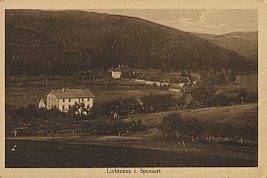
Lichtenau around 1900
|
|
Lichtenau is a hamlet belonging to the municipality of Rothenbuch in the Lower Franconian district of Aschaffenburg .
geography
Lichtenau is located in the Spessart in the Hafenlohr valley between Rothenbuch and Erlenfurt on the AB 6 district road, right on the border with the Main-Spessart district . To the north, the boundaries of the community-free areas Rothenbucher Forst and Forst Lohrerstraße .
history
The original Lichtenau stud belonged to Kurmainz in the late Middle Ages . An iron hammer was located there from 1813 to 1871 .
Web links
- Location of Lichtenau on the BayernAtlas
