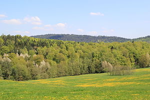
French head (Spessart)
| French head | ||
|---|---|---|
|
The Franzosenkopf (background) seen from Geiselbach in Bavaria |
||
| height | 481 m above sea level NHN | |
| location | Aschaffenburg district (Bavaria), Main-Kinzig district (Hesse) | |
| Mountains | Spessart | |
| Dominance | 9.2 km → Greifenberg | |
| Notch height | 76 m ↓ N from Glashütte | |
| Coordinates | 50 ° 8 '55 " N , 9 ° 13' 24" E | |
|
|
||
| rock | Red sandstone | |
The Franzosenkopf , also called Kreilberg , is a 481 meter high mountain in the Spessart in the district of Aschaffenburg in Bavaria and the Main-Kinzig district in Hesse .
Surname
It is often assumed that the name Franzosenkopf comes from a French gun emplacement on the mountain that the Napoleonic army is said to have used to control the Kinzig valley on their retreat after the Battle of Leipzig and before the Battle of Hanau . According to more recent findings, however, the term French head was found on forest plans in the 18th century, even before the Napoleonic Wars .
geography
The Bavarian / Hessian border leads over the summit of the Franzosenkopf. The northern part of the mountain lies within the district of Linsengericht (district of Großenhausen ), the southern part is part of Westerngrund (district of Geiselbacher Forst ). This area was free of parishes until 2014 . At the foot of the Franzosenkopf the Huckelheimer Bach rises in the south, the Näßlichbach and the Lochgraben in the west and the Eichelbach in the north.
The Birkenhainer road runs along the Hufeisenhof over the French head. In the southeast it goes flat to the Glasberg (476 m) and in the south to the Hohe Berg (441 m). To the southwest are the Gleisberg (352 m) and the Rochusberg (333 m). In the north , the Raue Heil (435 m) stretches behind the mountain saddle "Hufeisen", which takes its name from an old blacksmith's shop . The summit of the Franzosenkopf is the topographically highest point of the communities Westerngrund and Linsengericht. Around the Franzosenkopf are the places Huckelheim , Waldrode and Breitenborn / Lützel .


