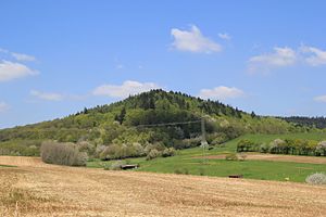
High mountain (western reason)
| High mountain | ||
|---|---|---|
|
The high mountain near Huckelheim |
||
| height | 441 m above sea level NN | |
| location | Bavaria , Germany | |
| Mountains | Spessart | |
| Dominance | 0.5 km → Franzosenkopf | |
| Notch height | 33 m | |
| Coordinates | 50 ° 8 '16 " N , 9 ° 13' 41" E | |
|
|
||
The Hohe Berg is a 441 meter high mountain in the Spessart near Westerngrund in the Aschaffenburg district in Bavaria .
geography
The high mountain is on the district Geiselbacher forest northwest of Huckelheim . This area was free of parishes until 2014 . Birkenhainer Straße leads over the mountain . In the north the Hohe Berg goes over to the Franzosenkopf (481 m). To the west, across State Road 2306 , are the Vorderer and Hinterer Gleisberg . The Hombach rises on the southern slopes of the Hohe Berg .
history

At the foot of the Hohe Berg there are a number of well-preserved boundary stones from 1810. They marked the border between two states of the Rhine Confederation ; on one side was the territory of the Alzenau office in the Starkenburg province of the Grand Duchy of Hesse , on the other side the department of Aschaffenburg in the Grand Duchy of Frankfurt with the village of Huckelheim.

