
Bald (river)
|
Kahl ( Historically : Kahlbach ) |
||
 The Kahl in Alzenau |
||
| Data | ||
| Water code | DE : 24772 | |
| location |
Sandstone Spessart
Büdingen-Meerholzer hill country |
|
| River system | Rhine | |
| Drain over | Main → Rhine → North Sea | |
| source |
Bald springs near the Bamberg mill at Kleinkahl 50 ° 7 ′ 17 ″ N , 9 ° 18 ′ 59 ″ E |
|
| Source height | 290 m above sea level NHN | |
| Spring discharge |
MQ |
50 l / s |
| muzzle | near Kahl am Main in the Main Coordinates: 50 ° 3 ′ 59 ″ N , 8 ° 59 ′ 29 ″ E 50 ° 3 ′ 59 ″ N , 8 ° 59 ′ 29 ″ E |
|
| Mouth height | 102 m above sea level NHN | |
| Height difference | 188 m | |
| Bottom slope | 5.8 ‰ | |
| length | 32.4 km | |
| Catchment area | 198.35 km² | |
| Discharge at the Schöllkrippen A Eo gauge : 64.43 km² Location: 27.2 km above the mouth |
NNQ MNQ 1987–2009 MQ 1987–2009 Mq 1987–2009 MHQ 1987–2009 HHQ (2006) |
52 l / s 168 l / s 720 l / s 11.2 l / (s km²) 15.5 m³ / s 31.4 m³ / s |
| Discharge at the Alzenau gauge (91.4% of the catchment area) A Eo : 181.2 km² Location: 6.6 km above the mouth |
NNQ (1991) MNQ 1983–2008 MQ 1983–2008 Mq 1983–2008 MHQ 1983–2008 HHQ (2002) |
189 l / s 541 l / s 1.89 m³ / s 10.4 l / (s km²) 25.9 m³ / s 48.7 m³ / s |
| Discharge A Eo : 198.35 km² at the mouth |
MQ Mq |
2.01 m³ / s 10.1 l / (s km²) |
| Left tributaries | see left tributaries | |
| Right tributaries | see rights tributaries | |
The Kahl is a 32 km long river in the district of Aschaffenburg in Bavaria and in the Main-Kinzig district in Hesse . It flows from east to west through the northern Spessart and flows into the Main at Kahl am Main as a right tributary . The source of the Kahl is near the village of Bamberger Mühle . The river gave the Kahlgrund its name.
Surname
The name Kahl comes from the Old High German word kaldaha and the Middle High German kalde , which means cold, cool, clear . The meaning of the basic word was also transferred to the tributaries Kleine Kahl , Westernkahl , Sommerkahl ( Speckkahl ) and Feldkahl . The Kahl gave the places Kahl am Main , Kahlmühle , Groß- and Kleinkahl as well as Kälberau and Kaltenberg (both from mhd. Kalde ) their names. The Kahl indirectly named the villages of Sommerkahl and Feldkahl .
geography
Bald springs

The bald springs are in the Wiesen forest at around 290 m above sea level. NHN on the outskirts of Bamberger Mühle , which today belongs to the municipality of Kleinkahl. The water of the Kahl flows from two spring taps on the left and right of the 2305 state road , with an average flow of 50 to 60 liters per second. After just a few meters, both source streams merge. The Kahltal-Spessart cycle path accompanies the river from the Kahlquelle to the mouth .
River course
In the upper bald ground

After its source in the upper Kahlgrund, the river flows in a south-westerly direction in the area of the municipality of Kleinkahl, in numerous loops past some fish ponds. On the right are the mountains Kapuzinerspitze (421 m), Lindenberg (465 m) and Habersberg (428 m). The Kahl passes the glassworks and the Wesemichshof and reaches the settlement area of Groß- and Kleinkahl. There you meet the Kleine Kahl from the southeast. Via Groß- and Kleinlaudenbach the Kahl reaches the municipality of the market Schöllkrippen .
In the center, under the bridge of the main road in 2306 , formerly Western Kahl flows called, from the Westerngrund coming Westerbach to. From Schöllkrippen, the Kahl is accompanied by the Kahl – Schöllkrippen railway line . From there, your river bed is partially straightened and provided with bank blocks.
In the middle bald ground

After Schöllkrippen, the Kahl flows through the district of Langenborn and meets one of its largest tributaries, the Sommerkahl , which bears the name Speckkahl in its upper reaches. Then it reaches the district of Blankenbach . At Erlenbach the Kahl changes its direction to the west and crosses the border to the market town of Mömbris .
At the Flederichsmühle near Königshofen , the river splits for about a kilometer. The right arm, the Mühlbach flowing through the village, was created to run the Geisenhof mill. The left part runs along the edge of the forest. The Kahl reaches its apex behind the town of Kaltenberg and the Kahltal bends to the northwest at Schimborn am Glasberg (334 m). Shortly afterwards the Reichenbach flows . The Kahl continues to flow through Mömbris, where it crosses under the 2305 state road and previously served as a drive for the now relocated oil mill . Past Strötzbach and Niedersteinbach the river reaches the district of Brücken . There the Kahl meets the Hemsbach , which rises at the foot of the Hahnenkamm , which is 437 m above sea level. NHN is the highest elevation in the Vorspessart. Behind bridges, the Kahl was the state border between Bavaria and Hesse for about 300 m until the area was swapped in 2011 . The Geiselbach flowing through the Teufelsgrund flows into this former Hessian bank and the Kahl crosses the border to the city of Alzenau at the sewage treatment plant .
In the further course the Kahltal becomes narrower and there separates the mountain ranges of the Hahnenkamm and Sölzert . At the Dörsthöfen the Kahl flows below the Poisonous Mountain (314 m) at the edge of the forest. The railway line runs along the right bank. From Michelbach the river leaves the narrow valley of the Kahlgrund, turns to the southwest and runs through flatter land.
In the lower bald ground

The Kahl flows over Kälberau into the area of the core town of Alzenau. In the city center, it is reinforced from the left at Alzenau Castle by the Krebsbach, which also rises from the Hahnenkamm . Consisting of waterless coming down Neuwiesenbach and springing on Waldschwimmbad Sälzerbach open at Generationenpark than the last two inflows into the Kahl.

After Alzenau, the Kahl was heavily straightened up to the A 45 . This section was renatured in 2014 as part of the Small State Garden Show 2015 in the area of the energy park. Several river islands and meanders were created. In the eastern Prischoss , the river is separated from the lower lying Meerhofsee by a dam from the sewage treatment plant . On August 11, 1981 it broke due to a severe flood and the water of the Kahl flowed into the lake; see also flood of the Kahl . The Kahl crosses under the A 45 and flows through a meadow landscape with pollard willows and poplars . It reaches the municipal boundary to Kahl am Main .
The Main-Spessart-Bahn and the former federal road 8 (today state road 3308) cross the river in the village . Behind the settlement area of Kahl am Main, the Hessian border extends to the Kahl at the Naßmühle. Not far from the decommissioned experimental nuclear power plant , which was dismantled by the end of 2008 , it flows into the Main .
Bald mouth

At the mouth of the river, the river bed of the Kahl was changed several times between 1900 and 1930 in order to mine lignite in the adjacent area . The Kahl flowed around the Emma-Süd opencast mine , which is now occupied by the Hornsee, in a wide arc . In its natural state, it ran a little north of today's mouth with a few turns in the Main. There it formed the Bavarian / Prussian (today Hessian) state border. The clearing regulation , which was also operated upstream , meant that more and more mills ceased operations. At the mouth of the Kahl is now at 102 m above sea level. NHN lowest point in Bavaria .
The Degen-Weg and the Kahltal-Spessart-Radwanderweg begin at the mouth of the Kahl .
Tributaries
The largest tributaries of the Kahl are (downstream): Westerbach , Sommerkahl , Reichenbach and Geiselbach


Kahl river system
Hydrology
Water flow

The mean discharge of the Kahl at the Alzenau gauge, which is 6.6 km above the mouth ( Lage ), is 1.89 m³ / s (1890 liters per second), which corresponds to a discharge rate of 10.4 l / (s · km²) corresponds. The calculated flow at the confluence with the Main results in 2.01 m³ / s. The mean high water discharge, measured from 1983 to 2008, is 25.9 m³ / s (25900 l / s), the mean low water discharge is 541 l / s. The lowest value since the start of the measurements was 189 l / s (September 10, 1991), see also section low water . The highest value ever measured is 48.7 m³ / s (48700 l / s, on February 13, 2002), see also section Floods . The zero point of the level in Alzenau is 117.59 m above sea level. NHN .
The average monthly discharge of the Kahl (measured at the Alzenau gauge):
Average monthly discharge of the Kahl (MQ in m³ / s) at the Alzenau gauge,
measurement period 1995–2015

As a rule, the water flow in the Kahl is greatest in the winter months and least in late summer. In January it has an average of more than three times as much water as in September. The mean annual runoff corresponds on average to the runoff in April.
Flood

|
| year | date | Discharge (m³ / s) |
|---|---|---|
| 1983 | Apr 9 | 30.6 |
| 1984 | Feb 7 | 30.7 |
| 1985 | Jan. 23 | 9.5 |
| 1986 | Jan. 19 | 12.8 |
| 1987 | 19 Dec | 25.8 |
| 1988 | April 1 | 29.8 |
| 1989 | Apr 22 | 22.2 |
| 1990 | Nov 18 | 24.6 |
| 1991 | Jan. 1 | 12.9 |
| 1992 | 14 Mar | 18.3 |
| 1993 | Dec. 21 | 28.0 |
| 1994 | 13 Apr | 20.5 |
| 1995 | Jan. 26 | 41.0 |
| 1996 | Feb 18 | 20.6 |
| 1997 | Feb 25 | 24.8 |
| 1998 | Oct 29 | 39.1 |
| 1999 | Feb 20 | 24.6 |
| 2000 | 4th Mar | 21.5 |
| 2001 | Nov 8 | 23.1 |
| 2002 | Feb 13 | 48.7 |
| 2003 | Jan. 3 | 43.0 |
| 2004 | 23 Sep | 28.0 |
| 2005 | Feb 13 | 18.4 |
| 2006 | 28th of May | 38.0 |
| 2007 | 7th Dec | 21.2 |
| 2008 | 1st Mar | 24.1 |
| 2009 | Jan. 23 | 24.8 |
| 2010 | Feb. 24 | 26.6 |
| 2011 | Jan. 7 | 30.6 |
| 2012 | 23 Dec | 31.2 |
| 2013 | 31. May | 24.5 |
| 2014 | 29 Jul | 13.1 |
| 2015 | Jan. 2 | 9.6 |
| 2016 | Feb 10 | 24.1 |
| 2017 | May 4th | 44.5 |
| 2018 * | Apr 14 | 31.2 |
When the water floods , the Kahl overflows its banks and floods the valley floor . The strongest floods of the Kahl in the 20th century were on November 3, 1924, December 21, 1952 and August 10, 1981. Only then did the measurement of the Alzenau and Schöllkrippen gauges begin.
1924
On the night of November 1st, a downpour fell over the Kahlgrund , which lasted for several hours. Already in the morning the Kahl overflowed its banks and you could watch how the flood got bigger and bigger. On the evening of this All Saints Day , further torrential rainfall began, which continued unabated throughout the night and the following day. The flood continued to rise at breakneck speed. A terrible catastrophe broke out over the entire Kahltal.
Disaster alarms were triggered in most locations. In Schöllkrippen the underpass of a bridge could not absorb the water masses and so the floods streamed along the path. After a short time the valley resembled a lake. Houses were threatened with collapse. Several landslides had already taken place on the railway embankment and it was feared that the dam would break through. In Kleinblankenbach , the stone Kahlbrücke was so dilapidated that it was no longer passable. The bridge between Krombach and Großblankenbach had completely disappeared.
The Mühlgasse in Mömbris was cut off from the rest of the village by the water. In addition, the transformer station collapsed . The bridge at the Strötzbacher Mühle was completely torn away. In the case of bridges , the Kahlbrücke was badly damaged, as was the railway bridge . Here, too, the transformer station fell victim to the floods. The road between Niedersteinbach and Hüttelngesäß was no longer passable. One was washed away at the Herrnmühle.
In order to see something in the dark, the fire brigade had set up posts with pitch torches at various places. A property in Michelbach had to be evacuated because there was a risk of it collapsing. The flood divided Alzenau into two parts. No train could pass the place anymore. The land in front of the brewery was torn away. This caused part of the wall to collapse. There was even a risk that the whole house would sink in the floods. But this did not happen. In contrast, the community backhaus and the transformer station disappeared in the flood. That is why the lights went out in some parts of Alzenau. The flood shot through Kaiser-Ruprecht-Strasse where it tore out the pavement. Below Alzenau, the Kahl tore away large stretches of shore. Because of this terrible devastation, the whole bank had to be rebuilt.
The municipality of Alzenau decided to take out an emergency loan of 21,000 marks in order to be able to repair the greatest damage. Even the oldest people at the time had never seen the Kahl so big and wide. It was the worst bald flood in a century.
1952

On the night of December 21, 1952, heavy rains fell over the entire Kahlgrund. Together with the melting of the snow, they caused an extraordinary increase in the otherwise peaceful baldness . This was in the morning hours quickly turned into a rushing stream and flooded vast tracts of land. The highest wave reached Schöllkrippen and Mömbris at 4 a.m. at 10 a.m.
The flood came mainly from the western bottom, but it had the worst effects in the middle and lower Kahlgrund. It grew to such an extent that the Red Cross and all fire departments were alerted. District Administrator Degen was out and about in the flooded area the whole morning to get an idea of the disaster and to make the necessary arrangements.
In a mill in Königshofen , the fire brigade was just able to prevent a large pile of wood from floating away. In cafeterias buttocks of the steep slope of a road slid down. The accumulating rainwater created heavy silting. In Niedersteinbach , an emergency footbridge was built from wagons from the mill to the rest of the town. Large amounts of sand, stones and mud were washed down from Dörnsteinbacher Berg and the canals were full in no time. At bridges , the whole meadow, including the sports field, was one huge lake. Sidewalks were washed away and the asphalt surface of the street was washed away.
In Alzenau the entire garden and meadow area was flooded left and right of the Kahl . A boy was even pulled from the bald at the sawmill. The residents of an alley could no longer leave their property on this Sunday from 11 a.m. At the parish church , the entire street was under water. Also Kahl am Main was hit by floods hard. In the area of the railway embankment, the Kahl was 100 meters wide and the huge floods tore away a footbridge. This December 21, 1952 flood was one of the largest in the Kahl in the 20th century.
1981

On the evening of August 9th, intense rainfalls with violent thunderstorms were reported from the upper and middle Kahlgrund. Later an exceptionally heavy downpour also fell in Alzenau. In a very short time, small rivulets turned into raging torrents. The torrential rains continued with undiminished intensity all night.
A tidal wave rolled through the western bottom, causing great damage. A disaster alarm was even triggered in the neighboring open- air court. In Huckelheim , the pavement of the street collapsed. Three high-voltage pylons overturned due to the mass of water ; as a result, the power supply was partially interrupted. The stream bed of the Westernkahl , which was otherwise no more than 2 m wide , was now over 20 m wide. In Schöllkrippen the bald level reached a height of 310 cm. The floods tore away a bridge.
State road 2305 was closed in many places due to flooding. The bridge at the Strötzbacher mill was torn away. In Niedersteinbach the Steinbach and Geiselbach were raging rivers. Landslides occurred between bridges and Strötzbach as well as near Hemsbach and the Heimbacher Mühle . Many helpers worked non-stop to free the streets and paths from the masses of earth. The traffic on the Kahlgrundbahn was interrupted by washed-out and muddy tracks, dam chutes and fallen trees. In the case of bridges, the embankment was completely torn away over a length of 50 m. In the afternoon the situation worsened because the rain didn't let up. The Hemsbach simply looked for the road in bridges as a new bed . At the 2305 state road, masses of earth slipped onto the roadway at the level of Dörsthof .
The footbridge at the Herrnmühle could no longer be used. However, the road from Alzenau to Kälberau was soon closed due to flooding. Here the floods of the Krebsbach flowed down, tore a hole in a wall and deposited meter-high masses of mud and rubble. Below Alzenau, huge holes were created in the dams on the Kahlufer. This enabled part of the Kahl to flow into the site of the sewage treatment plant. There fences and concrete posts were torn from the ground. The pressure of the flowing water finally led to a dam break and the brown broth spilled into the Meerhofsee . Its water level - which has fallen steadily in recent years - rose by around 6 meters.
Above Kahl am Main, the Kahl was almost 70 m wide. It was not until the afternoon of August 11 that the flood began to decline gradually. Now the full extent of the disaster became apparent. At the Strötzbacher mill, the technical relief organization had built an emergency footbridge over the Kahl. In Brücken the Hemsbach was moved back to its old bed. The damage to a street in Alzenau required a completely new building. The traffic of the Kahlgrundbahn was stopped until August 18th.
2017

more pictures
On May 4, 2017, a heavy storm of red level , with up to 80 liters of precipitation per square meter, moved over the Kahlgrund. The market in Mömbris and the municipality of Krombach were hit hardest. The heavy rain made the bald and small tributaries overflow their banks. Mainly the districts Mensengesäß, Niedersteinbach, Krombach, Strötzbach, Brücken, Oberschur, Unterschur, Mömbris and Dörnsteinbach were affected. Schöllkrippen, Huckelheim and Blankenbach also reported severe flood damage.
In particular, the levels of the Steinbach , Oberschurbach , Krombach , Fleutersbach and Hemsbach brooks rose so rapidly in a short time that the pipes in front of the locations could no longer absorb the water masses. As a result, streets and underpasses, basements and ground floors of around 400 to 500 households flooded, and landslides broke.
The fire brigades with 650 men moved from the surrounding towns. They were supported by fire brigades from the entire district of Aschaffenburg and partly from the district of Miltenberg. Two units of the technical relief organization were in action in the Mömbris area . Flooded bridges, uprooted trees, gully covers shooting up and significant traffic obstructions kept the rescue workers on their toes until late at night.
Sometimes the water was meters high in the cellars. The power went out there for a short time. In Niedersteinbach, a mudslide slid down the through-road. About 40 streets were closed for hours, so that villages with only a few access roads were cut off from the outside world. There was no getting through on the 2305 state road between Alzenau and Mömbris, the through-road of the particularly badly affected municipality of Krombach and the district road between Krombach and Schöllkrippen. Wheel loaders tried to clear the lanes. The traffic on the Kahlgrundbahn had to be stopped because the rails were washed away and debris was blocking the tracks.
In the Brücken district, the foundations of the bridge there were so undermined by the floods of the Kahl that it is only passable for cars. At the cemetery in Niedersteinbach, the masses of water have dented a retaining wall. There, the paths were rinsed out in such a way that holes up to 80 centimeters deep were created. In addition, graves were washed under, causing them to sag and shift. About 150 graves suffered total losses. The cemetery has been closed until further notice.
At the Herrenmühle requested were also sandbags lined up, yet was not to prevent the Kahl burst its banks. In addition, the water watch was alerted. More and more police officers moved into flooded towns to regulate traffic and block roads through which masses of mud were rolling. “In the Kahlgrund land is under. All fire departments have moved out, ”said the head of the Alzenau police. Mömbris Mayor Felix Wissel spoke of "immense damage in the public and private sector" . Because of the floods, the Mömbris school bus could not drive. The scared children were brought to safety in the fire station and town hall.
How it came to the bad storm that hit the Altkreis Alzenau : first a precipitation area formed over Niedersteinbach. After that, a strong thunderstorm cell with heavy rain developed , which had its center in the area of the Mensengesäß and Niedersteinbach. Later, intense downpours came down around Krombach. After that, a large area from bridges to the Kahlquelle was covered by heavy rain for a long time.
The Kahl reached its highest water discharge of around 45,000 liters per second at the Alzenau gauge at 9 p.m. The water level was increased by about 3 m at this time. Since the beginning of the water level measurements, this bald flood in May 2017 was the second strongest to date. The bald level was only higher in February 2002, but there was significantly more damage in 2017 because the floods mainly related to the small tributaries of the Kahl . There was damage of over 10 million euros in the Mömbris market alone. In the Krombach community, it is estimated at 1.2 million euros.

April 1989 in Alzenau
Flow at the time: approx. 25 m³ / s
more pictures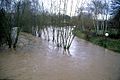
January 1995 in Alzenau
Flow at the time: approx. 25 m³ / s
more pictures
November 1998 in Alzenau
Flow at the time: approx. 20 m³ / s
more pictures
February 2002 in Alzenau
Flow at the time: approx. 35 m³ / s
more pictures
May 2006 in Niedersteinbach
Flow at the time: approx. 35 m³ / s
more pictures
December 2012 in Strötzbach
Flow at the time: approx. 30 m³ / s
more pictures

.jpg)

.jpg)
.jpg)
.jpg)
Low tide


|
| year | date | Outflow (l / s) |
|---|---|---|
| 1983 | Nov. 24 | 481 |
| 1984 | 23 Aug | 731 |
| 1985 | Nov 26 | 576 |
| 1986 | 4th Aug | 479 |
| 1987 | Oct 12 | 941 |
| 1988 | Oct 21 | 525 |
| 1989 | 14 Aug | 483 |
| 1990 | 13 Aug | 384 |
| 1991 | Sep 10 | 189 |
| 1992 | Aug 12 | 450 |
| 1993 | Aug 18 | 324 |
| 1994 | 19 Oct | 519 |
| 1995 | Aug 12 | 659 |
| 1996 | 22 Jul | 547 |
| 1997 | Sep 24 | 381 |
| 1998 | Sep 2 | 353 |
| 1999 | 16 Sep | 415 |
| 2000 | Jun 18 | 577 |
| 2001 | 29 Aug | 424 |
| 2002 | Sep 9 | 588 |
| 2003 | 21 Sep | 231 |
| 2004 | Jan. 3 | 417 |
| 2005 | Sep 10 | 463 |
| 2006 | Nov 7 | 466 |
| 2007 | May 24th | 545 |
| 2008 | Oct 13 | 580 |
| 2009 | Oct 9 | 549 |
| 2010 | Jul 21 | 297 |
| 2011 | 4th Jun. | 564 |
| 2012 | Sep 11 | 599 |
| 2013 | Oct. 3 | 757 |
| 2014 | 10 Aug | 604 |
| 2015 | 14 Aug | 394 |
| 2016 | 16 Sep | 456 |
| 2017 | Jan. 6 | 360 |
| 2018 * | 1 Aug | 510 |
Low water occurs in the Kahl after long periods of drought in the summer months. In the river bed, gravel banks and the roots of the trees on the banks are often visible. Smaller, mostly nameless tributaries of the Kahl also run dry. The lowest water runoff was measured in 1991, 2003 and 2010.
history
Mills

The Kahl used to run many mills. All of them are shut down today. Above all, the mill shutdown policy in the 1950s and 1960s, as well as the increased competition from the large mills that resulted, put them off. Some water wheels are still preserved today.
Former mills on the Kahl:
- Kahlmühle ( Bamberg Mill )
- Kahler Mühle (Großkahl)
- Hergelsmühle ( Großlaudenbach )
- Lower mill (Großlaudenbach)
- Forstmühle ( Schöllkrippen )
- Straw mill (Schöllkrippen)
- Gassenmühle (Schöllkrippen)
- Parish mill (Schöllkrippen)
- Sackmill (Schöllkrippen)
- Kihn-Mühl ( Langenborn )
- Blankenbacher Mühle ( Blankenbach )
- Flederichsmühle ( Königshofen )
- Geisenhof mill (Königshofen)
- Kaltenberger Mill ( Kaltenberg )
- Obermühle ( Schimborn )
- Untermühle (Schimborn)
- Oil mill ( Mömbris )
- Obermühle (Mömbris)
- Hellenthalsmühle ( Fronhofen )
- Strötzbacher Mühle ( Strötzbach )
- Kahlmühle ( Niedersteinbach )
- Herrnmühle ( Michelbach )
- Obermühle (Michelbach)
- Kihn mill (Michelbach)
- Kälberauer Mühle ( Kälberau )
- Christmühle ( Alzenau )
- Oil mill (Alzenau)
- Hasenmühle (Alzenau)
- Paper mill (Alzenau)
- Sandmill ( Kahl a. M. )
- Upper Fallermühle (Kahl a. M.)
- Lower Fallermühle (Kahl a. M.)
- Schäfereimühle (Kahl a. M.)
- Naßmühle ( Großkrotzenburg )
- Lohmühle (Kahl a. M.)
See also the list of mills in the Kahlgrund .
Bald regulation

Bald regulation was started in the 1830s and continued into the 20th century. The areas in which the river bed has been straightened the most are between Schöllkrippen and Blankenbach, near Strötzbach, between Dörsthöfen and Kälberau, between Alzenau and the A 45 and at the mouth of the Kahl. Especially in the area between the Dörsthöfen and Michelbach, the bed of the Kahl was heavily changed. Before that, it flowed to the right of today's state road 2305 to Obermühle, whose buildings are now on the outskirts of Michelbach. Also in 1977 when the state road in Mömbris was expanded, the river bed was changed so that the old oil mill had to be shut down and relocated.
As part of the regulation, the course of the river was cleaned and deepened. There were meanders straightened and bends to reduce flooding. In the city of Alzenau, this regulation was renatured in 2014 .
fauna

In the Kahl there are grayling , brown trout , brook loach , river perch , gudgeon , hazel , carp , arbor , nose , rainbow trout , roach , tench , eel , aitel and tailor , as well as the American signal crab .
In Kahlgrund come dipper , the kingfisher , the red-backed shrike , the common frog , the mountain and the newt , and the Burnet-Large Blues before.
Even beavers have settled at the Kahl at the Kahl.
See also
Web links
- Level at Schöllkrippen, HND Bavaria
- Gauge near Alzenau, HND Bavaria
- The Kahl, water portraits Aschaffenburg water management office
- The Kahl on Haas' map (around 1800)
Individual evidence
- ↑ Bayernviewer of the Bavarian Surveying Administration: Historical maps from the years 1817–1841
- ↑ a b TOP 10 Bavaria North
- ↑ Information board at the Kahlquellen
- ↑ Map services of the Bavarian State Office for the Environment
- ↑ Flood Action Plan Main ( Memento of the original dated September 6, 2009 in the Internet Archive ) Info: The archive link was inserted automatically and has not yet been checked. Please check the original and archive link according to the instructions and then remove this notice.
- ↑ a b Bavarian flood news service (accessed on September 6, 2013)
- ↑ Alzenau gauge value increased by the drainage of the remaining catchment area (17.15 km²), determined from the data from the Rück , Hainstadt , Goldbach , Harreshausen , Alzenau , Hanau , Kleinheubach and Frankfurt a. M. Osthafen
- ↑ Stone and water in the Aschaffenburg district
- ^ Wolf-Armin von Reitzenstein : Lexicon of Franconian place names. Origin and meaning . Upper Franconia, Middle Franconia, Lower Franconia. CH Beck, Munich 2009, ISBN 978-3-406-59131-0 .
- ↑ a b c d e Gerhard Nees & Hermann Kehrer: Alzenauer Wetterchronik . The most interesting weather events in Alzenau, in the Kahlgrund and on the Untermain from 365 to 1999. Reinhold Keim Verlag, Großkrotzenburg 2002, ISBN 3-921535-51-4 .
- ^ Archaeological Spessart Project e. V.
- ↑ a b c d e f g h Read on the website of the Bavarian Flood Intelligence Service
- ↑ Sat1 news: Severe weather in Lower Franconia
- ↑ News of the Bavarian Radio: Severe weather in the district of Aschaffenburg ( Memento from October 19, 2017 in the Internet Archive )
- ↑ Land under: Million damage in the Kahlgrund
- ↑ Form for Our Kahlgrund 2018 . Homeland yearbook for the Alzenau district. Published by the working group for homeland research and homeland maintenance of the Alzenau district, district administrator. ISSN 0933-1328 . (Written by Hermann Kehrer, author of the Alzenauer Wetterchronik.)
- ↑ Our Kahlgrund 1982-2000 . Homeland yearbook for the Alzenau district. Published by the working group for homeland research and homeland maintenance of the Alzenau district, district administrator. ISSN 0933-1328 .
- ^ Hydraulic straightening and regulation of the river Kahl
- ↑ Fishing Association of Lower Franconia: Our Waters ( Memento of the original from September 25, 2014 in the Internet Archive ) Info: The archive link was automatically inserted and not yet checked. Please check the original and archive link according to the instructions and then remove this notice.
- ↑ Kahlgrund , LBV protection area in the Aschaffenburg district (Lower Franconia)
- ↑ The beaver is coming back , ÖKOMELDER, Aschaffenburg, July 2015, Bund Naturschutz in Bayern e. V.