Oberschurbach
|
Oberschurbach ( Historically : Mensengesäßerbach ) |
||
|
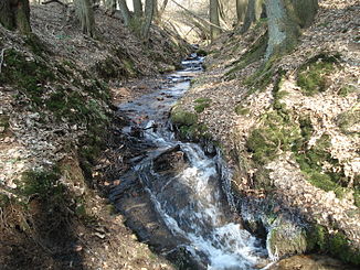
The Oberschurbach between Oberschur and Mensengesäß |
||
| Data | ||
| location |
Spessart
|
|
| River system | Rhine | |
| Drain over | Kahl → Main → Rhine → North Sea | |
| source | southwest of Oberschur 50 ° 5 ′ 4 ″ N , 9 ° 11 ′ 3 ″ E |
|
| Source height | 293 m above sea level NHN | |
| muzzle | in the Mensengesäß in the Kahl coordinates: 50 ° 4 '10 " N , 9 ° 9' 59" E 50 ° 4 '10 " N , 9 ° 9' 59" E |
|
| Mouth height | 165 m above sea level NHN | |
| Height difference | 128 m | |
| Bottom slope | 49 ‰ | |
| length | 2.6 km | |
| Catchment area | approx. 2.2 km² | |
The Oberschurbach is a brook in the Bavarian Spessart , which flows into the middle Kahl from the right and northeast in Mensengesäß in the district of Aschaffenburg .
geography
course
The Oberschurbach rises from the so-called Born , an old well , less than 150 m southwest of the outskirts of Oberschur in the forest. It flows steadily towards the southwest through the Bocksgrund to Mensengesäß , halfway past the sports field . Opposite him the brook runs from the Daßgrund , which rises near the Hüttenberg chapel . In the Mensengesäß the Oberschurbach is completely piped. A little above the Kahlbrücke on Bahnhofstrasse ( Staatsstrasse 2305 ), it flows into the Kahl from the right after about 2.6 km of Lauf between the stop on the Kahl – Schöllkrippen railway line and the current location of the old oil mill .
Catchment area
The catchment area covers around 2.2 km², the highest point in it is the Herrenberg on the northwestern watershed to the Steinbach at a little over 345 m above sea level. NHN . Elsewhere, too, the right and left edge hills, which are quite flat on top, often reach over 330 m above sea level. NHN . In the north-west the Steinbach competes beyond the watershed , in the north-east the Krombach rivers over tributaries , in the south-east the catchment area of the Schloßgrundgraben pushes itself in front of it ; these brooks all run to the right of the bald.
A large quarter of the catchment area in the northeast and east belongs to Krombach , the rest to Mömbris. On the upper reaches, the border between the communities follows the stream for a long time.
Tributaries
- Bach from the Daßgrund (right)
Kahl river system
See also
Web links
Individual evidence
- ↑ Bayernviewer of the Bavarian Surveying Administration: Historical maps from the years 1817–1841 ( Memento of the original from March 4, 2016 in the Internet Archive ) Info: The archive link was inserted automatically and has not yet been checked. Please check the original and archive link according to the instructions and then remove this notice.
- ↑ According to the contour line image on the Bavaria Atlas.
- ↑ a b BayernAtlas of the Bavarian State Government ( notes )
- ↑ Measured on the Bavaria Atlas.
- ↑ Our Kahlgrund 2004 . Homeland yearbook for the Alzenau district. Published by the working group for homeland research and homeland maintenance of the Alzenau district, district administrator. ISSN 0933-1328 .

The Oberschurbach flows into the Kahl
|

