Krombach (Kahl)
| Krombach | ||
|
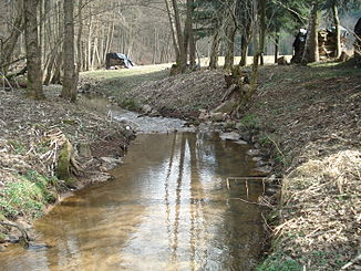
The Krombach in Unterschur |
||
| Data | ||
| location |
Spessart
|
|
| River system | Rhine | |
| Drain over | Kahl → Main → Rhine → North Sea | |
| source | in a wet meadow above Krombach 50 ° 5 '53 " N , 9 ° 11' 45" E |
|
| Source height | 297 m above sea level NHN | |
| muzzle | in Großblankenbach in the Kahl coordinates: 50 ° 3 '46 " N , 9 ° 13' 38" E 50 ° 3 '46 " N , 9 ° 13' 38" E |
|
| Mouth height | 187 m above sea level NHN | |
| Height difference | 110 m | |
| Bottom slope | 18 ‰ | |
| length | 6 km | |
| Catchment area | 7.7 km² | |
| Left tributaries | Ohlenbach | |
| Right tributaries | Gitzenbach | |
|
The mouth of the Krombach (left) in the Kahl |
||
The Krombach is a northern and right tributary of the Kahl in the Lower Franconian district of Aschaffenburg in the Bavarian Spessart, about six kilometers long .
Surname
Originally, Krombach means something like curved stream . The stream gave its name to the community of the same name.
geography
course
The Krombach rises in the municipality of Krombach northwest of the main town at an altitude of 297 m above sea level. NHN in an as Krombach source designated wet meadow . There, water collects in numerous places and drains into a channel . In the further course it flows through the district of Oberkrombach , where the Gitzenbach coming from Oberschur flows in from the right. In Mittelkrombach , the Krombach used to run the upper mill . The Mittelmühle was located behind Unterkrombach in the district of Unterschur . A little further below, the Ohlenbach flows into the Krombach from the left, which then flows over the border to the municipality of Blankenbach .
In the district of Großblankenbach the Krombach fed the former Untermühle . It crosses under the Kahltal-Spessart-Radweg and the Kahlgrundbahn through an underpass built in 2002 and finally flows out at an altitude of 187 m above sea level. NHN in the bald .
The approximately 6 km long course of the Krombach ends approximately 110 meters below its source, so it has an average bed gradient of approximately 18 ‰.
Catchment area
The 7.7 km² catchment area of the Krombach lies in the Spessart and is drained through it via the Kahl, the Main and the Rhine to the North Sea.
It borders
- in the northeast to the catchment area of the Westerbach , which flows into the Kahl
- to the east and south to that of the Kahl itself
- in the south-west of the catchment areas of the two Kahl tributaries Sterzenbach and Schloßgrundgraben
- in the west to that of the Oberschurbach , also a tributary of the Kahl
- in the northwest to that of the Kahl tributary Steinbach
- and in the north to that of the Geiselbach , which also flows into the Kahl.
Tributaries
- Gitzenbach (right)
- Ohlenbach (left)
Kahl river system
history
Mills
- Obermühle (Mittelkrombach)
- Mittelmühle (Unterschur)
- Untermühle (Großblankenbach)
See also the list of mills in the Kahlgrund .
See also
Web links
Individual evidence
- ↑ a b c d BayernAtlas of the Bavarian State Government ( notes )
- ^ Wolf-Armin von Reitzenstein : Lexicon of Franconian place names. Origin and meaning . Upper Franconia, Middle Franconia, Lower Franconia. CH Beck, Munich 2009, ISBN 978-3-406-59131-0 , p. 124 ( limited preview in Google Book search).
- ↑ Municipality map of Krombach

