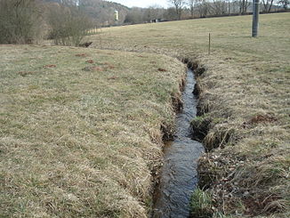
Gitzenbach
| Gitzenbach | ||
|
The Gitzenbach west of Krombach |
||
| Data | ||
| location |
Spessart
|
|
| River system | Rhine | |
| Drain over | Krombach → Kahl → Main → Rhine → North Sea | |
| source | east of Dörnsteinbach 50 ° 5 ′ 25 ″ N , 9 ° 11 ′ 22 ″ E |
|
| Source height | 295 m above sea level NHN | |
| muzzle | in Mittelkrombach in the Krombach coordinates: 50 ° 5 '20 " N , 9 ° 12' 33" E 50 ° 5 '20 " N , 9 ° 12' 33" E |
|
| Mouth height | 245 m above sea level NHN | |
| Height difference | 50 m | |
| Bottom slope | 33 ‰ | |
| length | 1.5 km | |
| Catchment area | 1.2 km² | |
The Gitzenbach is a right tributary of the Krombach in the district of Aschaffenburg in the Bavarian Spessart .
geography
course
The Gitzenbach rises east of Dörnsteinbach below the sports field . It flows in an easterly direction to Mittelkrombach , where it flows into the Krombach .
Tributaries
- Brook from the Ochsengrund (left)
Kahl river system
See also
Web links
Commons : Gitzenbach - Collection of images, videos and audio files
Individual evidence

The Gitzenbach (pipe on the left) flows into the Krombach
