Lindenberg (Kleinkahl)
| Lindenberg | ||
|---|---|---|
|
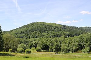
The southern upstream spur mountain of the Lindenberg seen from the Kahltal |
||
| height | 465 m above sea level NHN | |
| location | Aschaffenburg district (Bavaria), Main-Kinzig district (Hesse) | |
| Mountains | Spessart | |
| Dominance | 0.65 km → Gaiersberg | |
| Notch height | 15 m | |
| Coordinates | 50 ° 8 '29 " N , 9 ° 16' 52" E | |
|
|
||
The Lindenberg is 465 m above sea level. NHN high mountain in the Spessart in the Bavarian district of Aschaffenburg and in the Hessian Main-Kinzig district in Germany .
geography
The Lindenberg lies between the Kahlgrund and the Bieber valley . The state border between Bavaria and Hesse runs a little north of the summit. The mountain peak itself is located in the former community-free area of Huckelheimer Wald . From there, a long spur mountain extends southeast into the valley of the Kahl , which has a 400 m high secondary peak, also called Lindenberg. This is partly on the Großkahler district. The valleys of Habersbach and Lindenbach run to the west and east of this upstream mountain . To the southwest of it lies the Wesemichshof in the Kahltal valley . The Kleine Roßbach rises on the northern slopes of the main summit . The Lindenberg goes flat in the northwest to the Gaiersberg (475 m). To the southeast it is connected to the Kapuzinerspitze (421 m) via the spur called Glasberg . North of the Lindenberg lies the village of Roßbach in the Biebertal .
The historic Birkenhainer Straße trade route leads over the Lindenberg .

