Bald ground

Coordinates: 50 ° 4 ′ N , 9 ° 10 ′ E
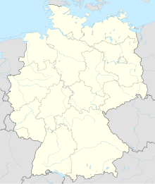
The Kahlgrund is a landscape in the northwestern Spessart in Bavaria and Hesse in Germany .
geography
The Kahlgrund extends in the catchment area of the eponymous river Kahl for the most part in the Bavarian district of Aschaffenburg and partly in the Hessian Main-Kinzig district . Until 1972, the Bavarian part was completely in the former Alzenau district (license plate ALZ). Side valleys such as the Westerngrund, the Hutzelgrund or the Teufelsgrund and the Prischoss are part of the Kahlgrund landscape. The name Kahltal, on the other hand, is only used for the valley of the Kahl from the Kahlquelle at the Bamberger Mühle to the confluence with the Main near Kahl am Main .
The municipalities in the Kahltal are (enumerated downstream) Kleinkahl , Schöllkrippen , Blankenbach , Mömbris , a part of the municipality Freigericht (settlement Hüttelngesäß ), Alzenau and Kahl am Main . Other communities that are in the Kahlgrund, but not directly on the Kahl, are Westerngrund , Sommerkahl , Krombach , part of Sailauf (district Eichenberg ), parts of the community Hösbach (districts Feldkahl and Rottenberg ), part of Johannesberg (district Breunsberg ) and Geiselbach . The Kahlgrund is divided into upper, middle and lower Kahlgrund.
places

Places in the Kahlgrund landscape and in the Kahltal:
The community-free areas Heinrichsthaler Forst and Schöllkrippener Forst as well as partly the Sailaufer Forst and the Wiesener Forst are located in the Kahlgrund . Former areas in the Kahlgrund, which are already part of a municipality, are the Geiselbacher Forst (2015 to Geiselbach and Westerngrund) and the Huckelheimer Wald (2019 to Westerngrund and Kleinkahl).
mountains
Striking mountains that border the Kahltal (sorted by height):
|
|
history

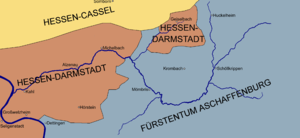
The Kahlgrund used to be crossed by the borders of historical territories .
In the Middle Ages , the lower and middle Kahlgrund formed the free court Wilmundsheim vor der Hart , which consisted of the four sub-courts Hörstein (also called "Court to Hart"), Mömbris , Somborn and Wilmundsheim (today Alzenau). At that time, Hörstein was the largest village in the open-air court. These four central courts , with their villages to be administered, united in the 12th century to form the Alliance of the High Marks . It was declared a free court in the Holy Roman Empire of the German Nation by King Barbarossa . It was under self-government and was directly imperial and without sovereigns .
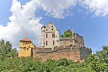
At that time, the upper Kahlgrund belonged to the Krombach Regional Court , which was part of the Mainz Electorate . He gave some areas as fiefs to various noble houses, such as the Lords of Büdingen , the Counts of Rieneck or those of Schönborn . The area of the Wilmundsheim free court was only granted to nobles who were directly subordinate to the empire. The largest landowner was the abbot of Seligenstadt Monastery , who also acted as Obermärker. Since the end of the 14th century, Kurmainz and the Counts of Hanau tried to gain control of the state in the free court. Kurmainz therefore built Alzenau Castle from 1395 to 1399 . The village that emerged below the castle, across from Wilmundsheim, received town charter in 1401 from King Ruprecht .
Inhabitants in the lower Kahlgrund:
|
In the early modern period , in 1500, the Roman Catholic Electorate of Mainz and the Lutheran Counts of Hanau-Münzenberg received the free court as an imperial fief under joint administration, despite the different denominations . Around the same time, the name of the village Wilmundsheim changed to Alzenau. In the 17th century, in the years after the Thirty Years' War in the Holy Roman Empire, the Rhenish Confederation was founded.
After the last Count of Hanau died in 1736, Kurmainz occupied the Freigericht militarily. The area was then divided. The Somborn court came to the Landgraviate of Hesse-Kassel , which later became part of the Electorate of Hesse , in 1740 as the Somborn Office (excluding Albstadt ) and was co-administered by the Altenhaßlau Office . The rest of the free court was incorporated into the Kurstaat Mainz as the Alzenau Office . Kurmainz created his own winery for the office , based in Alzenau Castle , which was responsible for administration and justice in the lower Kahlgrund. In the middle and upper Kahlgrund there was the Kaltenberg office and the Krombach office .
At the beginning of the 19th century, when the Rheinbund was founded , the Electoral Mainz Oberamt Steinheim with the Amt Alzenau came to the Landgraviate of Hessen-Darmstadt in 1803 . In 1811 the former Alzenau office was enlarged to include the bailiwick of the Geiselbach rule, which also fell to Hessen-Darmstadt in 1802 (an exclave with the villages of Geiselbach , Omersbach , Hofstädten and Rothenberg, which previously belonged to the Seligenstadt abbey ). The Landgraviate of Hesse-Darmstadt was elevated to the Grand Duchy of Hesse by Napoleon in 1806 and the Alzenau office came to the Grand Ducal Province of Starkenburg . The Altenhaßlau office was under the administration of the Principality of Hanau from 1807 to 1810 . At that time, the upper Kahlgrund belonged to the Principality of Aschaffenburg , which arose after the conquest of Mainz by France in the Napoleonic Wars , from the Vizedomamt Aschaffenburg , i.e. the remaining area of the Mainz Electoral State. This principality was under the rule of Imperial Arch Chancellor Karl Theodor von Dalberg and, like the Principality of Hanau, became a department of the Grand Duchy of Frankfurt in 1810 . Aschaffenburg remained the residential city of the entire Grand Duchy .
After the Congress of Vienna and the establishment of the German Confederation , the upper Kahlgrund and the entire area of the old Principality of Aschaffenburg (including the administrative area around Orb ) belonged to the Kingdom of Bavaria from 1814 . Only two years later did the Alzenau office become Bavarian. The district courts of Alzenau and Kaltenberg were established. The part of the Kahlgrund that had now become part of Bavaria was absorbed in 1817 by this incorporation and the annexation of the Grand Duchy of Würzburg in the newly created Lower Main District , the forerunner of Lower Franconia .


In the course of the administrative reforms in the Kingdom of Bavaria, most of the villages in the Kahlgrund became independent municipalities with the municipal edict of 1818. In 1829 the Kaltenberg Regional Court was dissolved and its territory was divided between the Aschaffenburg and Alzenau regional courts . In 1838, the Untermainkreis district was renamed Lower Franconia and Aschaffenburg . In 1840 the Hüttelngesäß manor district from the Kingdom of Bavaria was added to the Gelnhausen district (forerunner of the district) in the Electorate of Hesse (from 1866, after the German War , Hesse-Nassau province in the Kingdom of Prussia ). On September 3, 1858, the district court of Schöllkrippen was formed from parts of the district court districts of Alzenau, Rothenbuch and the area of the dissolved district court of Kaltenberg, which was incorporated into Aschaffenburg.
In 1862, after the judiciary and administration were separated, the Alzenau district office was formed by merging the Alzenau and Schöllkrippen district courts, on whose administrative territory the entire Bavarian Kahlgrund was located. In 1939, as everywhere in the German Reich, the designation district was introduced. The district office became the district and the Kahlgrund thus belonged to the district of Alzenau . The boundaries of the district were now seen as the boundaries of the Kahlgrund. The name of the district of Lower Franconia and Aschaffenburg was changed to Mainfranken at the same time .
In 1945, the previously Prussian province of Hesse-Nassau, which also included Hüttelngesäß and the area north of the Kahl estuary, and the People's State of Hesse (previously the Grand Duchy of Hesse), on the opposite side of the Main, became Greater Hesse (now the State of Hesse ) in the American zone of occupation united. The Bavarian administrative district of Mainfranken got its current name Unterfranken in 1946.
With the dissolution of the district of Alzenau in 1972, its area came into the newly formed district of Aschaffenburg . In the course of this regional reform in Bavaria , many of the originally independent communities in Kahlgrund were merged. In 1974 the neighboring Hessian districts of Gelnhausen and Hanau were then incorporated into the Main-Kinzig district .
Historically, the upper part of the valley was one of the last emergency areas in Bavaria / Franconia with very high levels of poverty . At that time, the barren agriculture was mainly supplemented by factory and home work (especially textile and cigar production). The increasing industrial settlement and the improved transport connections have made the Kahlgrund today a rather affluent area with close connections to the Rhine-Main area .
Previous locations

Places in the Kahlgrund that no longer exist today (today's district in brackets ):
|
|
|
Place names in Kahlgrund that no longer exist today (today's district in brackets):
|
|
climate
|
Climate table: (Average number of days in the year)
|
The entire Kahlgrund lies in the temperate climate zone . In the winter months in particular, the upper and middle Kahlgrund areas have on average greater amounts of precipitation than the lower ones. Usually July is the warmest and January the coldest month of the year. The lowest measured temperature of the Kahlgrund since measurements began (1946) on February 10, 1956, was −22.8 ° C ; the highest on July 25, 2019 at 40.3 ° C. Kahl and Großwelzheim in the lower Kahlgrund are the warmest places in Bavaria.
On average, precipitation falls between 700 and 1000 l / m² in the Kahlgrund (890 l / m² in Niedersteinbach, 710 l / m² in Kahl). The average length of sunshine a year is 1528 hours. On about 70 days the temperatures in the Kahlgrund are on average below zero degrees Celsius ( frost days ); There are days with permafrost ( ice days ) in about 11. On about 15 days a year there is a measurable snow cover in the Kahlgrund ( snow cover day ). Days over 25 ° C ( summer days ) are around 61 on average, days over 30 ° C ( hot days ) around 18 and desert days two.
Before the start of global warming in 1988, an average of around 84 frost days, around 17 ice days, around 29 days of snow cover, around 48 summer days, 12 hot days and no desert day were recorded in the Kahlgrund.
Economy and Infrastructure
Agriculture and viticulture
Well-known local products are apple wine (locally: Äbbelwoi) and fruit brandies . Franconian wine is also grown in the lower Kahlgrund in the wine towns of Michelbach (Aloisengarten, Apostelgarten, Goldberg and Steinberg), Wasserlos (Luhmännchen, Schlossberg) and Hörstein (Abtsberg, Käfernberg and Reuschberg). In Albstadt , viticulture was practiced north of the road to Neuses (old vineyard terraces can still be seen) until the end of the 19th century . The street name Wingertstraße in Alzenau is also reminiscent of a vineyard that used to be there .
traffic
Since 1898, the entire valley from Schöllkrippen has been traversed by a standard-gauge railway line and is now connected to the Rhein-Main transport network. The trains on the Kahl – Schöllkrippen railway line are called "Bembel" in local usage. Historic trains with steam locomotives also use this route on some public holidays such as Easter or Labor Day .
The national road 2305 extends Kahlgrund of Michel Bach to Bamberger mill. The A 45 crosses the Kahltal near Alzenau .
KVG bus lines are also available.
In the Kahltal the Kahltal-Spessart-Radwanderweg runs from Kahl am Main to the Kahlquelle . The Degen-Weg leads from the mouth of the Kahl to Dr.-Kihnplatz near Wiesen. The Franconian Marienweg also runs through some places on the Kahlgrund.
Culture and sights
The most famous sights in the Kahlgrund are:
- Kahlquellen , the two protected sources of the Kahl near the Bamberg mill
- Former geographic center of the European Union in Oberwestern
- Altort von Schöllkrippen , with the town hall (former castle) and St. Lukas chapel
- Wilhelmine mine , former copper mine near Sommerkahl
- Local history museum in Gunzenbach
- Oil mill , half-timbered mill near Mömbris
- Mill museum in the Strötzbacher mill
- Hahnenkamm , highest mountain in the Vorspessart with a lookout tower
- Teufelsmühle , hunting log cabin near Omersbach
- Michelbacher Schlösschen with museum
- Pilgrimage church Maria zum Raue Wind
- Alzenau Castle , late Gothic castle from the 14th century
- Park area of the State Garden Show in Alzenau from 2015
- Parish Church of the Assumption of Mary, fortified church in Hörstein from 1449
Churches and chapels
Almost all the Catholic churches of the Kahlgrund are in the district of the Deanery Alzenau . Small peripheral areas are in the area of activity of the deaneries Aschaffenburg-East and Aschaffenburg-West . The Protestant church buildings are located in the area of the Deanery Aschaffenburg . The following churches are in the Kahlgrund (place and parish community in brackets):
Catholic:
|
|
Evangelical:
- Church of the Redeemer (Dettingen)
- Kreuzkirche (Kahl)
- Peter and Paul (Alzenau)
- St. Markus (Schöllkrippen)
natural reserve
The entire middle and upper Kahlgrund lies in the Spessart Nature Park .
Nature reserves
The following nature reserves are in the Kahlgrund:
- Alzenauer Sande (NSG-00439)
- Sommergrund amphibious reserve (NSG-00232)
- Speckkahl amphibian sanctuary (NSG-00187)
- Spessartwiesen (NSG-00586)
- Gustavsee bird sanctuary (NSG-00382)
The following areas were proposed as nature reserves by the Bavarian State Ministry for Regional Development and the Environment in the 1980s:
- Hollow road near Kälberau
- Schanzenkopf near Michelbach
- Goldbachgrund near Michelbach
Landscape protection areas
The following landscape protection areas are located in the Kahlgrund:
- Landscape protection area Landscape areas in the district of Aschaffenburg (LSG-00293.01) near Alzenau, Michelbach, Hörstein, Großwelzheim and Kahl
- Landscape protection area Lindigwald (LSG-00293.02) near Dettingen
Protected landscape components
There are the following protected landscape elements in the Kahlgrund :
- Hollow road near Kälberau
- Kahlauen at Schöllkrippen
Natural monuments
There are numerous natural monuments in the Kahlgrund . Examples are:
Others

Streets in Aschaffenburg , Blankenbach , Breunsberg , Schimborn and Wenighösbach are named after the Kahlgrund .
literature
- Josef August Eichelsbacher: Home book of the Kahlgrund . Part I, history and sagas . 1928.
- Josef August Eichelsbacher: Home book of the Kahlgrund . Part II, country and people . 1930.
- Our bald ground. Homeland yearbook for the Alzenau district. Published by the working group for homeland research and homeland maintenance of the Alzenau district, district administrator . ISSN 0933-1328 (1956-2015).
Web links
- Schöllkrippen market
- Blankenbach community
- Mömbris market
- City of Alzenau
- Kahl community
- Kahlgrund Genealogy
- Literature on Kahlgrund in the Hessian Bibliography
Remarks
- ↑ a b c d e f g h i Due to its location in the former Alzenau district, it is part of the Kahlgrund landscape. Alzenau and Kahlgrund districts were partly synonymous .
- ↑ a b c Due to its location in the Kahl catchment area, it is included in the Kahlgrund landscape.
- ↑ The decrease in population in the 17th century came about through the plague , witchcraft and devastation during the Thirty Years' War.
- ↑ The borderline of the historical territories can be shown very differently. The affiliation of some villages could not be proven exactly. The place names were entered in their current form.
- ↑ Former place name of today's village Dörnsteinbach
- ↑ Former name of the upper village of Steinbach. The name of the lower village was transferred to the whole of today's Niedersteinbach.
- ↑ not recorded until 1870
- ↑ a b c Measured in Alzenau
- ↑ Measured in Kahl am Main
Individual evidence
- ↑ Alzenau / Wilmundsheim, Freigericht
- ↑ Life and coexistence in the former "Free Court in front of the Welmisheim Mountains"
- ^ Gerhard Nees & Hermann Kehrer: Alzenauer Wetterchronik . The most interesting weather events in Alzenau, in the Kahlgrund and on the Untermain from 365 to 1999. Reinhold Keim Verlag, Großkrotzenburg 2002, ISBN 3-921535-51-4 .
- ↑ Information board of the Archaeological Spessart project: Albstadt, medieval settlement


