Omersbach (Geiselbach, place)
|
Omersbach
Community Geiselbach
Coordinates: 50 ° 6 ′ 35 ″ N , 9 ° 11 ′ 31 ″ E
|
|
|---|---|
| Height : | 284 m |
| Residents : | 687 (Jan 3, 2012) |
| Incorporation : | January 1, 1972 |
|
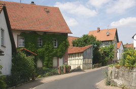
Partial view of the village street
|
|
Omersbach has been a district of Geiselbach in the Lower Franconian district of Aschaffenburg in the west of the Spessart since January 1, 1972 .
geography
Omersbach is located in the Kahlgrund between the villages of Hofstädten and Dörnsteinbach at 284 m, about one kilometer from the Hessian border. The Omersbach stream of the same name flows through the village . The village of Krombach is located southeast of Omersbach . The Frohnbügel homestead is located in the north-west on the edge of the Sölzert . The topographically highest point of the village mark is located south of the village, at the Aussiedlerhof near Dörnsteinbach at 331 m above sea level. NN (location) , the lowest is in the Teufelsgrund on the Geiselbach at 180 m above sea level. NN (location) .
history
In the Middle Ages and in the early modern period, Omersbach belonged to the Seligenstadt Monastery , which in turn was subordinate to Kurmainz . In 1802, troops of the Landgraviate of Hessen-Darmstadt occupied the monastery, and on April 1, 1803, with the Reichsdeputationshauptschluss , it officially fell to Hessen-Darmstadt. For the following years Omersbach belonged to the Landgraviate, from 1806 to the Grand Duchy of Hesse . On January 30, 1816, the Grand Duchy and the Kingdom of Bavaria signed a treaty that agreed to the exchange of a number of areas: Omersbach came to Bavaria.
The municipality of Omersbach belonged to the Alzenau district office , which was formed on July 1, 1862. On January 1, 1939, this became part of the Alzenau district in Lower Franconia .
Culture and sights
- The historical Teufelsmühle is located in the nearby so-called Teufelsgrund .
- The Rosenberg house at Dorfstrasse 32 consists of high-quality demolition material from the Schönborn court building on the Schöneberg near Krombach .
- The desolation of the Rothenberger Hof lies on the outskirts of Omersbach .
- Every year a steam and agricultural machinery festival takes place in Omersbach .
Web links
Individual evidence
- ^ Wilhelm Volkert (ed.): Handbook of Bavarian offices, communities and courts 1799–1980 . CH Beck, Munich 1983, ISBN 3-406-09669-7 , p. 418 .
- ↑ Bavaria Atlas of the Bavarian State Government ( notes )
- ↑ Anja Kalinowski: The former Benedictine Abbey Seligenstadt. Guide through the monastery complex and showrooms = edition of the administration of the State Palaces and Gardens of Hesse. Brochure 30. Schnell + Steiner, 2nd edition Regensburg 2008, p. 11.
- ↑ Arthur Benno Schmidt : The historical foundations of civil law in the Grand Duchy of Hesse . Curt von Münchow, Giessen 1893, p. 17f and note 61.
- ↑ Spessart project: Teufelsmühle - On the becoming and passing of the three mills in the Omersbachtal
- ↑ Spessart project: wayside shrines and the "Rosenberger House"
- ^ The higher jurisdiction in the Schönborn territory
- ^ Spessart project: In the Krombacher district court
- ^ Die Gusseisernen - Land and Steam Engine Friends Kahlgrund e. V.

