Sölzert
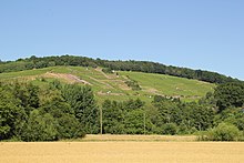
The Sölzert is a wooded range of hills in the northwestern Spessart in the south of the Main-Kinzig district in Hesse and in the north of the Aschaffenburg district in Lower Franconia . In Bavaria the name Sülzert is used for the forest area . At 371 m, the Heidkopf is the highest point in the Sölzert.
geography

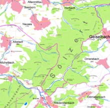
The Sölzert stretches from Kahlgrund in the south over the Schanzenkopf (365 m) and Heidkopf (371 m) to Geiselbach in the north. There it is bounded by the valley of the Näßlichbach . Albstadt and Neuses border in the west. Around the Sölzert are the other villages of Horbach , Omersbach , Niedersteinbach and Michelbach . Share and the village Altenmittlau whose local district over the Schnellmichbachtal in the Sölzert draws.
The state border between Hesse and Bavaria runs in the middle of the Sölzert, with the Hessian area, which belongs entirely to the municipality of Freigericht , being the larger. Most of the Bavarian area is in the urban area of Alzenau . On the east side, the Sölzert is bounded by the Teufelsgrund that runs there . In the south, the Sölzert ridge, only separated by the very narrow Kahltal valley, continues in the Hahnenkamm ridge ( poisonous mountain ).
In addition to the highest peak of the Sölzert, there are three more called Heidkopf in the north near Geiselbach. These adjacent peaks are called Heidköpf on maps .
Minor peaks
The main and secondary peaks of the Sölzert are:
|
|
history
The forest area from Hörstein to Geiselbach used to be called the Hohe Mark . It was an area of 3857 acres, which was shared by the four main courts Wilmundsheim (today Alzenau ), Hörstein , Mömbris and Somborn . The Hohe Mark consisted of two parts, one north and the other south of the Kahl . The southern area is known today as the Hahnenkamm, the northern area was already called the Sölzert at that time.
Buildings and sights
- The Frohnbügel homestead is located in the northeast of the Sölzert .
- On the west side near Neuses there is an inn with a viewing tower ( Rodfeld Tower ) and until January 2007 the natural monument Rodfeldeiche , which fell victim to Hurricane Kyrill .
- In the southwest near Michelbach is the Apostelgarten vineyard (under monument protection since 1985) with its vineyard houses .
- In the far south are the Dörsthöfe .
- In the area between Geiselbach and Neuses there are some barrows from the Neolithic as well as from the early Iron Age that are designated as cultural monuments .
- The historic Birkenhainer Straße trade route and, until 2019, the Franconian Marienweg run through Sölzert .
Web links
- At the Sülzert (PDF; 1.6 MB)
- The Sölzert in the Bayernviewer
Individual evidence
Coordinates: 50 ° 6 ′ 22 ″ N , 9 ° 9 ′ 6 ″ E


