Heidkopf (Spessart)
| Heidkopf | ||
|---|---|---|
|
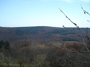
The summit of the Heidkopf from the neighboring mountain over the Teufelsgrund , seen from the southeast |
||
| height | 371 m above sea level NHN | |
| location | Bavaria , Hessen , Germany | |
| Mountains | Spessart | |
| Dominance | 2.4 km → Hohe Mark | |
| Notch height | 71 m ↓ in Geiselbach | |
| Coordinates | 50 ° 6 '16 " N , 9 ° 8' 58" E | |
|
|
||
| Type | Low mountain range | |
The Heidkopf is 371 m above sea level. NHN high mountain in the Spessart in the Bavarian district of Aschaffenburg and in the Hessian Main-Kinzig district . The national border is on the top of the wooded mountain. It is the highest mountain in the Sölzerthöhenzug .
geography
The Heidkopf is located on the western slope of the Teufelsgrund , a side valley of the Kahlgrund , between Alzenau - Albstadt and Mömbris . In between runs a small part of Hesse , which belongs to the large municipality of Freigericht . The Heidkopf is the highest point in the Albstadt and Freigericht area. In the south the mountain is directly related to the Schanzenkopf ( 365 m ), in the north with the Sölzertsberg ( 351 m ), also known as the Metzkopf. The entire area is called Sölzert and was once part of the Hohen Mark . The highest point of the Heidkopf summit is on the Bavarian side and is the topographically highest point in the district of Albstadt. It can be reached via a forest path from Frohnbügel . The Franconian Marienweg led over the Heidkopf until 2019 .
See also
Web links
- Location of the Heidkopf on the BayernAtlas
- The Heidkopf in the Freigerichter Bay (PDF; 2.7 MB)
Individual evidence
- ↑ Federal Agency for Cartography and Geodesy , State Office for Surveying and Geoinformation Bavaria : Digital Topographic Map 1:10 000, BayernAtlas , accessed on March 23, 2014

