
Glasberg (Mömbris)
| Glasberg | ||
|---|---|---|
 The Glasberg seen from the Sterzenbachweiher |
||
| height | 334 m above sea level NHN | |
| location | Bavaria , Germany | |
| Mountains | Spessart | |
| Dominance | 2.1 km → Ratsberg | |
| Notch height | 27 m ↓ in Daxberg | |
| Coordinates | 50 ° 3 '12 " N , 9 ° 10' 6" E | |
|
||

The Glasberg is a 334 meter high mountain in the Spessart in the Bavarian district of Aschaffenburg .
geography
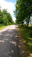
At the foot of the mountain in the Kahltal is the Mömbris district of Schimborn , on the flat south-east slope Daxberg is 313 m above sea level. NHN . The Glasberg, which forms a small ridge with the adjacent Daxberg (338 m), is bounded in the northwest by the Reichenbach valley , in the southeast by the Weibersbach , in the southwest by the Steinbach and in the northeast by the Kahl . State road 2305 runs there at the foot of the Glasberg . The glass forest is located on the northwest slope . The Degen-Weg ran over the mountain until 2011 .
Data
The directly adjacent Daxberg dominates over the Glasberg at 338 m. The notch height to him is 2 m. The Daxberg is in turn surpassed by the Ratsberg northeast of Johannesberg . The gap to him is 27 m deep.
history
The Glasberg takes its name from the Claswald , mentioned in old documents , which is derived from the Klausenwald, a forest that probably belonged to the Schimborner Beginenklause , which was built around 1284. Klause is an old name for a hermitage .
On the Glasberg there has been a BR transmission mast since 1970, which was replaced by a higher authority radio transmission mast in 2014 .
In the 20th century, the Glashof (Daxberger Hof), Glasbergstrasse and Glasberghalle in Daxberg were named after the mountain .
See also

The Glasberg from Bauernberg seen from

Summit area of the glass mountain
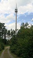
The transmitter mast on the Glasberg
Summit area of the Daxberg


Web links
Individual evidence
- ^ Original position sheet of land surveying in Bavaria: Sailauf and surroundings in 1850
- ↑ Topographical Atlas of the Kingdom of Bavaria on this side of the Rhine Sheet: 10 (1860)
- ↑ Bavaria Atlas of the Bavarian State Government ( notes )