Oberwestern
|
Oberwestern
Community Westerngrund
Coordinates: 50 ° 6 ′ 56 ″ N , 9 ° 14 ′ 31 ″ E
|
|
|---|---|
| Height : | 257 m above sea level NN |
| Residents : | 706 (June 20, 2012) |
| Incorporation : | January 1, 1972 |
|
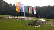
The (former) geographic center of the European Union marked with a flag in Schulzengrundstrasse in Oberwestern
|
|
Oberwestern is a district of the municipality Westerngrund in the Bavarian district of Aschaffenburg . The place has 706 inhabitants.
geography
Oberwestern is 257 m above sea level. NN on the road between Unterwestern and Huckelheim in Westerngrund, a side valley of the Kahltal through which the Westerbach flows.
After Croatia's accession to the European Union , from July 1 to December 31, 2013, the geographic center of the EU was in the Oberwestern am Schulzengrundbach (Lage) district . Before that, the center was in the town of Meerholz in Hesse . After the previous French overseas territory with special status Mayotte was declared a regular department of France and became part of the European Union on January 1, 2014 as an outermost region ("OMR": Outermost Regions), this point changed on January 1, 2014 shifted about 500 m to the south (location) . Since the Brexit on January 31, 2020, the center has moved to Gadheim in the municipality of Veitshöchheim near Würzburg.
The topographically highest point of the village mark is to the northwest of the village, on the Ziegelberg at 358 m above sea level. NN (location) , the lowest is on the Westerbach at 229 m above sea level. NN (location) .
Surname
The place got its name from the Bach Western (today Westerbach) where it is located. For the meaning of the name, see Name des Westerbach and for earlier spellings in the article Westerngrund, the section: Earlier spellings .
history
Oberwersten was mentioned in a document 700 years ago and had a chapel for the Holy Cross from the middle of the 15th century . The Oberwestern church was built in 1828.
The municipality of Oberwestern belonged to the Alzenau district office , which was formed on July 1, 1862. On January 1, 1939, this became part of the Alzenau district in Lower Franconia .
On January 1, 1972, Oberwestern was incorporated into the municipality of Westerngrund.
Web links
Individual evidence
- ↑ measured against the church
- ↑ Westerngrund is the center of the European Union
- ↑ The center is a damp meadow in Oberwestern
- ↑ Will Westerngrund lose its EU focus?
- ↑ Brief fame, Tagesspiegel of December 30, 2016
- ↑ Bavaria Atlas of the Bavarian State Government ( notes )
- ^ Wolf-Armin von Reitzenstein : Lexicon of Franconian place names. Origin and meaning . Upper Franconia, Middle Franconia, Lower Franconia. CH Beck, Munich 2009, ISBN 978-3-406-59131-0 , p. 240–241 ( limited preview in Google Book search).
- ^ Wilhelm Volkert (ed.): Handbook of Bavarian offices, communities and courts 1799–1980 . CH Beck, Munich 1983, ISBN 3-406-09669-7 , p. 418 .


