Summer bald (bacon bald)
|
Sommerkahl upper course: Speckkahl ( Historically : Sonderkahl ) |
||
|
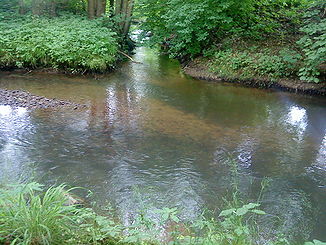
The Sommerkahl west of Sommerkahl |
||
| Data | ||
| Water code | DE : 247724 | |
| location |
Spessart
|
|
| River system | Rhine | |
| Drain over | Kahl → Main → Rhine → North Sea | |
| source | in Ruhborn east of Sommerkahl 50 ° 4 ′ 3 ″ N , 9 ° 18 ′ 18 ″ E |
|
| Source height | 354 m above sea level NHN | |
| muzzle | near Langenborn in the Kahl coordinates: 50 ° 4 ′ 26 ″ N , 9 ° 14 ′ 15 ″ E 50 ° 4 ′ 26 ″ N , 9 ° 14 ′ 15 ″ E |
|
| Mouth height | 193 m above sea level NHN | |
| Height difference | 161 m | |
| Bottom slope | 32 ‰ | |
| length | 5 km | |
| Catchment area | 12.63 km² | |
|
The mouth of the Sommerkahl at Langenborn in the Kahl |
||
The Sommerkahl , formerly also called Sonderkahl or Sonderkahlerbach , is a left tributary of the Kahl in the district of Aschaffenburg in the Bavarian Spessart . It rises below the Engländers and flows into the Kahl at Langenborn . From the upper reaches to the entrance of Sommerkahl the brook is called Speckkahl .
Surname
The name Sommerkahl comes from the Middle High German word "Sumer" , which means summer . This refers to the sunny location in the lower valley section. For the origin of the word Kahl see Name of Kahl . The brook gave the place Sommerkahl its name.
The name Speckkahl comes from a time when there were only a few paths in the Spessart. Until the first half of the 20th century , the summer people carried their ham and bacon along this stream and on over the English to Jakobsthal , formerly known as the “Knöpphütte”. There the residents exchanged buttons (hence the name) and glass beads for the food from Sommerkahl.
geography
course
The two short source streams of the Speckkahl arise east of Sommerkahl at the wooded foot of the Eselshöhe ridge , on the western slope of the Spindelberg ( 520 m above sea level ), below the Engländers . The source of the longer right Quelbaches is in the unincorporated area Schoell Krippener forest lying Ruhborn .
The confluence of the two streams and the further course of the Speckkahl are located in the 44 hectare amphibious reserve Speckkahl nature reserve . It then meanders through the meadows of six clearings in the nature reserve and is reinforced by the streams of the layer springs Finkenborn and Steinbergsborn .
After the Speckkahl has left the forest in a westerly direction, the stream from the Fuchsborn flows into it from the right and it serves as a water supply for some fish ponds . From around the Wilhelmine mine , at the entrance to Sommerkahl, the Speckkahl is then called Sommerkahl . There the Degen-Weg crosses the stream.
The Sommerkahl flows through the upper and lower villages of the village of the same name and was previously used to operate the Obermühle , Glasermühle , Geßnermühle , Pfaffsmühle and Antonsmühle . To the west of Sommerkahl, it crosses under the 2305 state road and flows into the Kahl at Langenborn .
The Sommerkahl besides Geiselbach , Reichenbach and Westerbach the largest tributary of the Kahl .
Kahl river system
nature and environment
Speckkahl amphibian sanctuary
The 44 hectares large amphibians sanctuary bacon Kahl , in the narrow valley of bacon Kahl, was in 1983 protected area declared. The valley, free of trees due to centuries of mining activities, with its swampy pristine meadows and boggy areas, is a specialty in the otherwise densely forested Spessart. Tender mosses grow in the soaked spring bog, and wet meadows bloom in the swampy valley. Pools and oxbow lakes are spawning areas for a large number of amphibians such as mountain newts and grass snakes .
history
Mills
- Obermühle
- Glasermühle (Gerts-Mühle)
- Geßnermühle
- Pfaffsmühle
- Antonsmühle (lower mill)
See also the list of mills in the Kahlgrund .
See also
Web links
- The summer bald on the BayernAtlas
- Map of the catchment area in the basic data for flowing waters of Bavaria, Bavarian State Office for the Environment
- Nature walks around Sommerkahl
Individual evidence
- ↑ Bayernviewer of the Bavarian Surveying Administration: Historical maps from the years 1817–1841 ( Memento of the original from March 4, 2016 in the Internet Archive ) Info: The archive link was inserted automatically and has not yet been checked. Please check the original and archive link according to the instructions and then remove this notice.
- ↑ Our Kahlgrund 1957 . Homeland yearbook for the Alzenau district. Published by the working group for homeland research and homeland maintenance of the Alzenau district, district administrator. ISSN 0933-1328 . Name of the headwater of the Geßnermühle: Sonderkahl
- ↑ a b BayernAtlas of the Bavarian State Government ( notes )
- ↑ GeoFachDatenAtlas and water services of the Bavarian State Office for the Environment
- ↑ Directory of brook and river areas in Bavaria - Main river area, page 158 of the Bavarian State Office for the Environment, as of 2016 (PDF; 3.3 MB)
- ↑ Position sheets 1: 25000 (1817-1856)
- ^ Wolf-Armin von Reitzenstein : Lexicon of Franconian place names. Origin and meaning . Upper Franconia, Middle Franconia, Lower Franconia. CH Beck, Munich 2009, ISBN 978-3-406-59131-0 , p. 209 ( limited preview in Google Book search).
- ↑ Speckkahl nature trail
- ↑ First recording (1808–1864)


