Skins
| coat of arms | Germany map | |
|---|---|---|

|
Coordinates: 50 ° 9 ′ N , 9 ° 35 ′ E |
|
| Basic data | ||
| State : | Bavaria | |
| Administrative region : | Lower Franconia | |
| County : | Main-Spessart | |
| Management Community : | Burgsinn | |
| Height : | 236 m above sea level NHN | |
| Area : | 34.35 km 2 | |
| Residents: | 849 (Dec. 31, 2019) | |
| Population density : | 25 inhabitants per km 2 | |
| Postal code : | 97778 | |
| Area code : | 09356 | |
| License plate : | MSP | |
| Community key : | 09 6 77 128 | |
| LOCODE : | DE FEE | |
| Community structure: | 4 districts | |
| Address of the municipal administration: |
Hauptstrasse 24 97778 Fellen |
|
| Website : | ||
| Mayoress : | Zita Baur ( CSU- Free Citizens Furs) | |
| Location of the municipality of Fellen in the Main-Spessart district | ||
Fellen is a municipality in the Lower Franconian district of Main-Spessart .
geography
Geographical location
The community is located in the Würzburg an der Fella region , just under three kilometers east of the Hessian-Bavarian border. The topographically highest point of the municipality is at 552 m above sea level. NN (location) on the Hermannskoppe , the lowest is on the Aura at 205 m above sea level. NN (location) .
Community structure
Four parts of the community belong to furs:
- Skins
- Rengersbrunn
There are the districts of Fellen and Rengersbrunn.
Neighboring communities
| Community Aura in the sense of reason |
||
| community Flörsbachtal |

|
Burgsinn market |
|
Haurain ( non- parish area) |
Ruppertshüttener Forst (community-free area) and the town of Lohr am Main |
Herrnwald (municipality-free area) |
Surname
etymology
The name Fellen comes from a plural form of Middle High German vëlt , which means field .
Earlier spellings
Earlier spellings of the place from various historical maps and documents:
- 1244 Velden
- 1277 Veldin
- 1338 Velden
- 1356 Felden
- 1420 skins
history
Until the church is planted
Fellen, first mentioned in 1244, was part of the County of Rieneck until it came to Mainz in 1559 , which it sold to the Counts of Nostitz in 1673 . They sold it to Count Colloredo- Mansfeld in 1803. In 1806 it was mediatized within the Principality of Aschaffenburg and with this it fell to Bavaria in 1814 . In the course of the administrative reforms in Bavaria, with the municipal edict of 1818, today's municipality, to which the hamlet Wohnrod belongs, was created.
Administrative history
In 1862 the district office Gemünden am Main was formed, on whose administrative area Fellen was located. In 1872 the Gemünden District Office was incorporated into the Lohr am Main District Office . It was not until 1902 that the Gemünden District Office was re-established. In 1939, as everywhere in the German Reich, the designation district was introduced. Fellen was now one of the 27 communities in the district of Gemünden am Main . With the dissolution of the district of Gemünden am Main, Fellen came to the newly formed district of Mittelmain on July 1, 1972, which ten months later received its final name, district of Main-Spessart .
Population development
In the period from 1988 to 2018, the population fell from 956 to 848 by 108 inhabitants or 11.3%.

Attractions
- Pilgrimage church in Rengersbrunn
Architectural monuments
Soil monuments
politics
The community is a member of the Burgsinn administrative community . Mayor has been Zita Baur (CSU-Free Citizens Fellen) since June 23, 2009; this was elected on March 15, 2020 with 80.0% of the votes for a further six years. Her predecessor Ekkehard Weimer (CSU / Free Voters) was mayor from May 1, 2008 until his death on January 23, 2009. In 2009, the second mayor, Klaus Werthmann, took over the office until the new election.
coat of arms
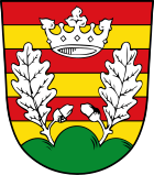
The description of the coat of arms introduced in 1981 reads: “Five times divided by red and gold; on top of two silver oak leaves with fruits growing from a green three-peaks a silver crown of leaves ”.
Economy and Infrastructure
Economy including agriculture and forestry
According to official statistics, there were 81 employees at the place of work in the manufacturing sector and 17 in trade and transport. There were a total of 329 employees at the place of residence subject to social security contributions. There was none in the manufacturing sector, and one in the construction sector. In 1999 there were 29 farms with an agricultural area of 328 hectares, of which 44 were arable land and 200 were permanent green areas.
education
There are the following institutions (as of 2018):
- A day-care center with 50 places and 32 children
Web links
Individual evidence
- ↑ "Data 2" sheet, Statistical Report A1200C 202041 Population of the municipalities, districts and administrative districts 1st quarter 2020 (population based on the 2011 census) ( help ).
- ↑ Town Hall & Citizen Service. Municipality of Fellen, accessed on June 30, 2020 .
- ↑ http://www.bayerische-landesbibliothek-online.de/orte/ortssuche_action.html ? Anzeige=voll&modus=automat&tempus=+20111119/191310&attr=OBJ&val= 1719
- ↑ a b Wolf-Armin von Reitzenstein : Lexicon of Franconian place names. Origin and meaning . Upper Franconia, Middle Franconia, Lower Franconia. CH Beck, Munich 2009, ISBN 978-3-406-59131-0 , p. 70 ( limited preview in Google Book search).
- ↑ http://www.vgem-burgsinn.de/sites/gensite.asp?SID=cms080920101130433483240&Art=674
- ↑ Entry on the coat of arms of fur in the database of the House of Bavarian History


