
Esselbach
| coat of arms | Germany map | |
|---|---|---|

|
Coordinates: 49 ° 51 ' N , 9 ° 32' E |
|
| Basic data | ||
| State : | Bavaria | |
| Administrative region : | Lower Franconia | |
| County : | Main-Spessart | |
| Management Community : | Marktheidenfeld | |
| Height : | 300 m above sea level NHN | |
| Area : | 11.93 km 2 | |
| Residents: | 2077 (Dec. 31, 2019) | |
| Population density : | 174 inhabitants per km 2 | |
| Postcodes : | 97839, 97836 | |
| Area code : | 09394 | |
| License plate : | MSP | |
| Community key : | 09 6 77 126 | |
| LOCODE : | DE FFR | |
| Community structure: | 3 districts | |
| Address of the municipal administration: |
Hauptstrasse 8 97839 Esselbach |
|
| Website : | ||
| Mayor : | Richard Roos ( CSU ) | |
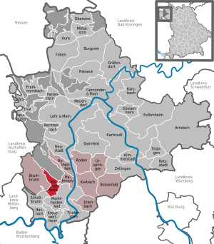
| Location of the municipality of Esselbach in the Main-Spessart district | ||
  |
||

Esselbach is a municipality in the Lower Franconian district of Main-Spessart .
geography

Highest and lowest point
The topographically highest point of the municipality is at 450 m above sea level. NN (location) on Karlshöhe, the lowest is on Wachenbach at 195 m above sea level. NN (location) .
Community structure
In addition to the main town, the municipality consists of two other districts and is divided into the following ten settlements:
There are the areas Esselbach (with Alte Wachenmühle and Neue Wachenmühle), Kredenbach, Steinmark (with Kieseckersmühle and Heinrichsmühle) and Fürstlich Löwensteinscher Park (with Faun, Karlshöhe and Schleifthor).
Neighboring communities
|
Fürstlich Löwensteinscher Park (community-free area) |
Community Hafenlohr |
|
| Community Bischbrunn |
.svg)
|
|
| Community Schollbrunn |
City of Marktheidenfeld |
Waters
The Esselbach and the Wachenbach , into which the Esselbach flows, flow through the village .
Surname
etymology
The name Esselbach is derived from the Esselbach stream of the same name , which flows into the Hafenlohr via the Wachenbach . The name "Esselbach" comes from the Middle High German term Espin, which means aspen and the basic word Bach. The explanation is that there is a stream of aspen. The change from n or l before b is not uncommon. The current form with ss was created through assimilation.
Earlier spellings
Earlier spellings of the place from various historical maps and documents:
- 1182 Espelbach
- 1424 Espilbach
- 1594 Eisselbach
- 1625 Esselbach
history
Until the founding of the forerunner churches
As part of the Hochstift Würzburg, the main town Esselbach as well as Steinmark and Kredenbach fell as parts of the Grafschaft Wertheim after the Reichsdeputationshauptschluss 1803 to the newly formed Principality of Aschaffenburg , with which they came to the Kingdom of Bavaria in 1814 . In the course of the administrative reforms in Bavaria, three independent municipalities were created with the municipal edict of 1818.
Administrative history
In 1862 the district office of Marktheidenfeld was formed, on whose administrative area Esselbach was located. In 1939, as everywhere in the German Reich, the designation district was introduced. Esselbach was now one of the 47 communities in the Marktheidenfeld district . With the dissolution of the district of Marktheidenfeld, Esselbach came to the newly formed district of Mittelmain on July 1, 1972, which ten months later received its final name, district of Main-Spessart .
Incorporations
In the course of the Bavarian regional reform, the previous communities Esselbach, Steinmark and Kredenbach merged on May 1, 1978 to form the new community Esselbach.
Population development
In the period from 1988 to 2018, the population increased from 1743 to 2096 by 353 inhabitants or by 20.3%.
- 1961: 1516 inhabitants
- 1970: 1627 inhabitants
- 1987: 1747 inhabitants
- 1991: 1938 inhabitants
- 1995: 2111 inhabitants
- 2000: 2041 inhabitants
- 2005: 2036 inhabitants
- 2010: 1975 inhabitants
- 2015: 2051 inhabitants
politics
The community is a member of the Marktheidenfeld administrative community .
mayor
Mayor has been Richard Roos (CSU) since July 23, 2013; he was re-elected on March 15, 2020 with 96.1% of the vote. His predecessor since 2002 was Klaus Hofmann (Free Voters).
Municipal council
The 14 municipal councils have been divided into three parliamentary groups since the 2014 local elections:
- CSU / Citizens' Block: 5 (2008: 3)
- Free voters: 5 (2008: 6)
- Citizen list: 4 (2008: 2)
- Citizens' community: - (2008: 3)
coat of arms
|
|
Blazon : "In green, a broad silver oblique left bar, on which a blue post horn is placed obliquely left." |
Community partnerships
There is a community partnership with Stetteldorf in Lower Austria.
religion
Esselbach is shaped by Catholicism. The parish of St. Margareta belongs to the Lohr deanery ( Diocese of Würzburg ).
The districts of Steinmark and Kredenbach, on the other hand, are evangelical and belonged to the county of Wertheim.
Architectural monuments
Soil monuments
education
There are the following institutions (as of 2016):
- a Catholic kindergarten with six kindergarten groups,
- a private school of universal life up to the tenth grade.
Web links
- Entry on the coat of arms of Esselbach in the database of the House of Bavarian History
Individual evidence
- ↑ "Data 2" sheet, Statistical Report A1200C 202041 Population of the municipalities, districts and administrative districts 1st quarter 2020 (population based on the 2011 census) ( help ).
- ↑ a b Archive link ( Memento of the original from April 2, 2015 in the Internet Archive ) Info: The archive link was inserted automatically and not yet checked. Please check the original and archive link according to the instructions and then remove this notice.
- ↑ Mayor. Esselbach municipality, accessed on June 28, 2020 .
- ↑ http://www.bayerische-landesbibliothek-online.de/orte/ortssuche_action.html ? Anzeige=voll&modus=automat&tempus=+20111119/185640&attr=OBJ&val= 1717
- ↑ Right click on BayernAtlas
- ↑ Right click on BayernAtlas
- ↑ Right click on BayernAtlas
- ↑ a b Wolf-Armin von Reitzenstein : Lexicon of Franconian place names. Origin and meaning . Upper Franconia, Middle Franconia, Lower Franconia. CH Beck, Munich 2009, ISBN 978-3-406-59131-0 , p. 67 ( limited preview in Google Book search).
- ↑ a b c Federal Statistical Office (ed.): Historical municipality directory for the Federal Republic of Germany. Name, border and key number changes in municipalities, counties and administrative districts from May 27, 1970 to December 31, 1982 . W. Kohlhammer GmbH, Stuttgart / Mainz 1983, ISBN 3-17-003263-1 , p. 763 .
- ^ Entry on the coat of arms of Esselbach in the database of the House of Bavarian History
- ^ Diocese of Würzburg: All deaneries . 2014 ( online [accessed May 8, 2014]).
Esselbach with Faun , Karlshöhe , Schleifthor , Wagenmühle (old) and Wagenmühle (new) | Kredenbach | Steinmark with Heinrichsmühle and Kieseckersmühle

Arnstein | Aura in the reason | Birkenfeld | Bischbrunn | Burgsinn | Erlenbach near Marktheidenfeld | Esselbach | Eußenheim | Skins | Frammersbach | Gemünden am Main | Gössenheim | Graefendorf | Hafenlohr | Hasloch | Sky city | Karbach | Karlstadt | Karsbach | Kreuzwertheim | Lohr am Main | Marktheidenfeld | Middle sense | Neuendorf | Neuhütten | Neustadt am Main | Obersinn | Partenstein | Rechtenbach | Retzstadt | Rieneck | Clearing | Rothenfels | Schollbrunn | Steinfeld | Thüngen | Triefenstein | Urspringen | Wiesthal | Zellingen
Municipality-free areas in the district of Main-Spessart
Burgjoss |
Forest aura |
Forest Lohrerstraße |
Frammersbach Forest |
Princely Löwensteinscher Park |
Haurain |
Herrnwald |
Langenprozeltener forest |
Partenstein Forest |
Ruppertshütten forest