
Upper sense
| coat of arms | Germany map | |
|---|---|---|

|
Coordinates: 50 ° 13 ' N , 9 ° 37' E |
|
| Basic data | ||
| State : | Bavaria | |
| Administrative region : | Lower Franconia | |
| County : | Main-Spessart | |
| Management Community : | Burgsinn | |
| Height : | 199 m above sea level NHN | |
| Area : | 11.7 km 2 | |
| Residents: | 931 (Dec. 31, 2019) | |
| Population density : | 80 inhabitants per km 2 | |
| Postal code : | 97791 | |
| Area code : | 09356 | |
| License plate : | MSP | |
| Community key : | 09 6 77 169 | |
| Market structure: | 2 districts | |
| Association administration address: | Burgweg 1 97775 Burgsinn |
|
| Website : | ||
| Mayoress : | Lioba Zieres ( Free Association of Voters ) | |
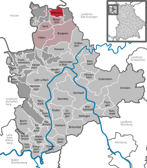
| Location of the Obersinn market in the Main-Spessart district | ||
  |
||

Obersinn is a market in the Lower Franconian district of Main-Spessart and a member of the Burgsinn administrative community .
geography
Geographical location
Obersinn is located in the Würzburg region and is divided into a Spessart and a Rhön side by the river Sinn, which gives it its name . The neighboring towns are called: Mittelinn and Jossa , as well as Zeitlofs-Roßbach and Aura im Sinngrund . There is also the district of Emmerichsthal. The Dittenbrunner Höhe is located near the village, named after the village of Dittenbrunn , which belongs to Altengronau . The topographically highest point of the municipality is at 472 m above sea level. NN (location) on the mountain Gäulsküppel, the lowest is on the Sinn at 196 m above sea level. NN (location) . The Obersinn viaduct on the Hanover – Würzburg high-speed line bears the name of the market. Obersinn has a train station on the Flieden – Gemünden line .
Community structure
Obersinn is divided into two districts:
- Upper sense
- Emmerichsthal
There are the districts of Burgjoss, Forst Aura and Obersinn.
Neighboring communities
|
Manor district Spessart (unincorporated area) |
community Sinntal |
Markt Zeitlofs and Roßbacher Forst (municipality-free area) |
| City of Bad Soden-Salmünster and Burgjoss (unincorporated area) |
.svg)
|
Forst Aura (unincorporated area) |
|
Forst Aura (unincorporated area) |
Community mean sense |
Surname
etymology
The basic word in the name goes back to the river Sinn flowing through the place . The addition Ober was used to distinguish Obersinn from the nearby villages Mittelinn and Niedersinn (today Burgsinn ) and indicates the location in the valley.
Earlier spellings
Earlier spellings of the place from various historical maps and documents:
- 1309 senses
- 1319 Upper Senses
- 1364 Upper Synne
- 1542 Obersynn
- 1695 Obersinn
history
Until the church is planted
Most of the local rights of the Würzburg bishopric , which belonged to the Franconian Empire , fell to the Principality of Aschaffenburg in 1808 (first to Bavaria in 1803, to the Grand Duchy of Würzburg in 1805 ), with which they came back to Bavaria in 1814 . Local rights of Hessen-Kassel fell to Bavaria only in 1860. In the course of the administrative reforms in Bavaria, today's municipality was created with the municipal edict of 1818 .
Administrative history
In 1862 the district office Gemünden am Main was formed, on whose administrative area Obersinn was located. In 1872 the Gemünden District Office was incorporated into the Lohr am Main District Office . It was not until 1902 that the Gemünden District Office was re-established. In 1939, as everywhere in the German Reich, the designation district was introduced. Obersinn was now one of the 27 communities in the district of Gemünden am Main . With the dissolution of the district of Gemünden am Main, Obersinn became part of the newly formed district of Mittelmain on July 1, 1972, which ten months later was given its final name as district of Main-Spessart .
Population development
In the period from 1988 to 2018, the population fell from 1209 to 944 by 265 inhabitants or 21.9% - the strongest percentage decrease in the Main-Spessart district in the period mentioned.

politics
Municipal council
Local election 2014:
- Free community of voters Obersinn: 8 seats
- CSU: 4 seats
mayor
Since May 1, 2008, Lioba Zieres (Free Voting Association) has been the first woman to manage a community in the former Altlandkreis Gemünden. She was elected for a further six years on March 15, 2020 with 91.6% of the vote. Her predecessor was Richard Stenglein (CSU). Second mayor is Rudolf Dill (Free Voting Community Obersinn).
Coat of arms and flag
Blazon : By a silver wave pole split from red and green, in front a silver shell over three silver tips, behind over a silver beech leaf a silver mark, which is composed of the capital letter H and the number 4.
The silver wave pole symbolizes the Sinntal and the sense that forms the border between the Rhön and Spessart. Obersinn is also on the border between Hesse and Bavaria. The rake represents the historical relationship with the Würzburg monastery. Approx. In 1400 Obersinn was raised from the bishopric to a parish. The shell stands for the church patron St. James. The green tinging and the beech leaf refer to the landscape of the market, which is characterized by agriculture, meadows and forests (especially beech forests). The marking drawing (visible on the boundary stones) represents the emblem of the condominium , which was created in 1447 , in which four gentlemen were involved (the Vierherrschaft) and which determined the history of the market area for about 350 years.
Approval of the coat of arms: June 27, 1984
Coat of arms draftsman: L. Breitenbach / G. Weismantel, Obersinn
Flag: red-white-green
Architectural monuments
Economy and Infrastructure

Economy including agriculture and forestry
In 1998, according to official statistics, there were no employees at the place of work in the manufacturing industry 64 or in the trade and transport sector. In other economic areas, 17 people were employed at the place of work subject to social security contributions. There were a total of 391 employees at the place of residence subject to social insurance contributions. There was one company in the manufacturing sector and two companies in the construction sector. In addition, in 1999 there were 22 farms with an agriculturally used area of 296 hectares, 94 hectares of which were arable land and 198 hectares of permanent green area.
education
Since July 2019 there has been a museum in the redesigned town center about the life and work of the writer and pedagogue Leo Weismantel, who was born in Obersinn . The exhibition rooms are located in the former Wischert House, a half-timbered house adjoining Weismantel's birthplace.
There are also the following institutions (as of 2011):
- Kindergarten: 25 kindergarten places with 28 children
- School Obersinn (until school year 2005/2006)
Events
- "Fire wheel" Every year on Shrove Monday an ancient ritual is performed on Brunnberg in Obersinn: The "fire wheel" is carried down the steep mountain by unmarried boys. Every year the spectacle attracts hundreds of visitors.
- Chess Flower Festival
Every year in April / May there is the chess flower festival in Obersinn. The chess flower occurs mainly in the meadows near the Reithbrücke in Obersinn.
- Eisenwahn Festival (2004-2013)
From 2004 to 2013 the Eisenwahn Festival took place annually on Ludwig-Zeller-Ring in Obersinn.
Sons and Daughters of the Market
- Leo Weismantel (1888–1964), writer
- Helmut Preisendörfer (1927–1984), football player
Web links
- Internet presence of the market
- Obersinn as part of the administrative community Burgsinn
- Entry on the coat of arms of Obersinn in the database of the House of Bavarian History
Individual evidence
- ↑ "Data 2" sheet, Statistical Report A1200C 202041 Population of the municipalities, districts and administrative districts 1st quarter 2020 (population based on the 2011 census) ( help ).
- ↑ http://www.bayerische-landesbibliothek-online.de/orte/ortssuche_action.html ? Anzeige=voll&modus=automat&tempus=+20111119/214913&attr=OBJ&val= 1738
- ↑ "District and municipality directory": Bavarian district directory (ZIP archive with text file)
- ↑ a b Wolf-Armin von Reitzenstein : Lexicon of Franconian place names. Origin and meaning . Upper Franconia, Middle Franconia, Lower Franconia. CH Beck, Munich 2009, ISBN 978-3-406-59131-0 , p. 171 ( limited preview in Google Book search).
- ↑ Obersinn has a Leo Weismantel Museum. Bayerischer Rundfunk , July 19, 2019, accessed on July 19, 2019 .

Arnstein | Aura in the reason | Birkenfeld | Bischbrunn | Burgsinn | Erlenbach near Marktheidenfeld | Esselbach | Eußenheim | Skins | Frammersbach | Gemünden am Main | Gössenheim | Graefendorf | Hafenlohr | Hasloch | Sky city | Karbach | Karlstadt | Karsbach | Kreuzwertheim | Lohr am Main | Marktheidenfeld | Middle sense | Neuendorf | Neuhütten | Neustadt am Main | Obersinn | Partenstein | Rechtenbach | Retzstadt | Rieneck | Clearing | Rothenfels | Schollbrunn | Steinfeld | Thüngen | Triefenstein | Urspringen | Wiesthal | Zellingen
Municipality-free areas in the district of Main-Spessart
Burgjoss |
Forest aura |
Forest Lohrerstraße |
Frammersbach Forest |
Princely Löwensteinscher Park |
Haurain |
Herrnwald |
Langenprozeltener forest |
Partenstein Forest |
Ruppertshütten forest