
Burgsinn
| coat of arms | Germany map | |
|---|---|---|

|
Coordinates: 50 ° 9 ′ N , 9 ° 39 ′ E |
|
| Basic data | ||
| State : | Bavaria | |
| Administrative region : | Lower Franconia | |
| County : | Main-Spessart | |
| Management Community : | Burgsinn | |
| Height : | 190 m above sea level NHN | |
| Area : | 51.36 km 2 | |
| Residents: | 2367 (Dec. 31, 2019) | |
| Population density : | 46 inhabitants per km 2 | |
| Postal code : | 97775 | |
| Area code : | 09356 | |
| License plate : | MSP | |
| Community key : | 09 6 77 122 | |
| LOCODE : | DE GVS | |
| Market structure: | 1 district | |
Market administration address : |
Burgweg 1 97775 Burgsinn |
|
| Website : | ||
| First Mayor : | Robert Herold (Burgsinn Citizen List) | |
| Location of the Burgsinn market in the Main-Spessart district | ||
  |
||

Burgsinn is a market in the Lower Franconian district of Main-Spessart and the seat of the Burgsinn administrative community .
geography
Geographical location
The municipality is located in the Main-Spessart region (neighboring district of Würzburg). The topographically highest point of the municipality district is located at 509 m above sea level. NN (location) on the Lohrer Höhe, the lowest is on the Sinn at 174 m above sea level. NN (location) .
Community structure
There are two officially named districts:
- Burgsinn
There is only the district Burgsinn.
Neighboring communities
| Community Aura in the sense of reason |
Community mean sense |
Forst Aura (municipality-free area) |
| Fellen municipality |
.svg)
|
Omerz and Red Mountain (municipality free area) and community Wartmannsroth |
|
Herrnwald (municipality-free area) |
City of Rieneck |
Community Gräfendorf |
Surname
etymology
The basic word of the original name Sinna goes back to the river Sinn flowing through the town . The addition in the name Niedersinn , which was used at times, was used to distinguish Niedersinn from the nearby villages of Obersinn and Mittelinn and indicated its location in the valley.
Earlier spellings
Earlier spellings of the place from various historical maps and documents:
|
|
history
Until the church is planted
A stone ax found in Burgsinn from the late Neolithic (around 2000 BC) is the oldest evidence of human presence in the local area. The Sinngau ("Sinnahgeuue") is mentioned in a document from the Fulda monastery from 812. The first written evidence of the existence of the place, the then Würzburg village of Sinna, dates back to 1001. During the time of the tribal duchies, the place belonged to the Duchy of Franconia . 1303 speaks of castle men of the "Gotzo, Aplo et Her (mannus) de Sinn" as occupying the border fortress of Sinna. In 1334 Emperor Ludwig the Bavarian granted "the village of Synne" market rights for "forever" . In 1338 Dietz von Thüngen became the hereditary castle man and lord of the castle and town of Sinna. In 1405, Dietz von Thüngen's son Wilhelm acquired the Burgsinn rulership and everything that went with it for 10,000 guilders .
In 1804 Burgsinn with Zeitlofs and the accessories Eckarts, Trübenbrunn, Rupboden, Roßbach, Weißenbach, Detter, Heiligkreuz, Völkersleier, Dittlofsroda, Weikersgrüben, Graefendorf and Höllich belonged to the Barons of Thüngen. They were located as enclaved possessions in the district court and rent office district of Gemünden in the Principality of Würzburg in Kurpfalzbayern.
In 1808 Burgsinn came to the Wolfsmünster District Commissariat of the Grand Duchy of Würzburg as an enclaved Thüngen patrimonial place. Heinrich Alsheimer and Friedrich Heilmann were mayor for the Lutzische line of the barons of Thüngen. Georg Köhler and Johann Schmitt were the mayors of the Andreasische Linie. The school teacher was Johann Dünkel. Back then, weekly messengers from Bugsinn to Würzburg and from Würzburg to Burgsinn went on Mondays. In Würzburg they stopped at the Golden Ship.
As a result of the Paris Treaty of June 3, 1814, Burgsinn and the Grand Duchy of Würzburg came to the Crown of Bavaria in June 1814.
In the course of the administrative reforms in Bavaria, today's municipality was created with the municipal edict of 1818 .
Administrative history
In 1862 the district office of Gemünden am Main was formed, on whose administrative area Burgsinn was located. In 1872 the Gemünden District Office was incorporated into the Lohr am Main District Office . It was not until 1902 that the Gemünden District Office was re-established. In 1939, as everywhere in the German Reich, the designation district was introduced. Burgsinn was now one of the 27 communities in the district of Gemünden am Main . With the dissolution of the district of Gemünden am Main, Burgsinn came to the newly formed district of Mittelmain on July 1, 1972, which was given its final name as district of Main-Spessart ten months later .


Religions
The parish of St. Michael Burgsinn is part of the Karlstadt deanery of the Würzburg diocese . The Catholic parish church, also known as "Sinntaldom", was the simultaneous church for Catholic and Protestant Christians in Burgsinn until the Evangelical-Lutheran Trinity Church was inaugurated in 1955 .
In November 1938 the Jewish synagogue was desecrated, and the last members of the community were deported and murdered in 1942.

Population development
In the period from 1988 to 2018, the population fell from 2,682 to 2,366 by 316 or 11.8%.

politics
mayor
Mayor has been Robert Herold (Burgsinn Citizens List) since May 2014. He was re-elected on March 15, 2020 with 69.0% of the vote.
coat of arms

|
|
Blazon : "A red ram's horn on a golden background." |
The Widderhorn can neither be taken from the coat of arms of the Barons of Thüngen nor that of the Counts of Rieneck , although both families are closely connected to the history of Burgsinn. While with the extinction of the Rothenfels line of the Rieneckers in 1333 half of the Burgsinn Castle, which the Counts of Rieneck had as a fief, fell back to Würzburg and in 1405 the Barons of Thüngen bought the entire castle of Würzburg, the Voit von Rieneck , which for a long time Vögte zu Rieneck held a part of the tithe and the court of middle sense until the 15th century. When Kurmainz carried out the execution against the Thüngen in 1630, the court in Burgsinn was held in the Rieneck cellar - the Counts of Rieneck had already died out in the first half of the 16th century. After the reinstatement of the Thüngen in Burgsinn in 1697, the community was expressly assured, along with various other agreements, that “their old village seal” would be retained. What kind of this seal was and what time it came from is not stated, but since the Voit von Rieneck had a ram in their coat of arms, it is almost certain that the coat of arms of Burgsinn was the reduced coat of arms of the Voit von Rieneck is.
Economy and Infrastructure
Economy including agriculture and forestry
According to official statistics, there were five employees at the place of work in the field of agriculture and forestry, 193 in the manufacturing sector and 140 in the trade and transport sector. In other areas of the economy 136 people were employed at the place of work subject to social security contributions. There were a total of 878 employees at the place of residence subject to social security contributions. There were three companies in the manufacturing sector and three in the construction sector. In addition, in 1999 there were 24 farms with an agriculturally used area of 371 ha, of which 29 ha were arable land and 325 ha were permanent green areas.
traffic
Burgsinn is on the high-speed line Hanover – Würzburg and the Flieden – Gemünden line . It is possible to switch between the two railway lines at the Burgsinn depot . The Burgsinn Tunnel is also located in the area that gives it its name.
broadcast
Burgsinn is the location of a filling station of the Bavarian Broadcasting Corporation .
Attractions
- The old castle
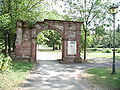
Castle park entrance

The attachment
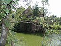
The moat

The place to the side

West side


- The castle, also called the Old Castle, is laid out like a typical moated castle. The layout is trapezoidal, with a tower at each of the four corners. At the entrance to the castle there is a huge donjon 22 meters high. Its walls have a side length of 2.50 meters and are 2.60 meters thick. The construction of the tower is dated to the 12th century. The remaining buildings were rebuilt or renewed in the 16th or 17th centuries.
- The New Castle of the Thüngen family was built from 1590 to 1620 in Renaissance style on the edge of the forest east of the Sinn .
- The third castle in Burgsinn is the so-called Fronhofer Schlösschen, also built in 1607 by the Thüngen family as a widow's seat.
- The characteristic building of the Catholic parish church St. Michael in neo-baroque forms was completed in 1908 instead of a previous building.
- The Evangelical Trinity Church with its free-standing bell tower was built in 1952 from red Main sandstone not far from the Catholic Church.
Architectural monuments
medicine
Medical care is provided by three general practitioners based in the area, a dentist, a pharmacy, two physiotherapists and the hospitals in Lohr, Karlstadt, Schlüchtern or Bad Brückenau, each about 30 kilometers away. In addition, there is an ambulance station of the Bavarian Red Cross in Burgsinn. It is equipped with an ambulance. The station is manned around the clock, seven days a week.
education
The following institutions exist (as of: 1999):
- Kindergarten: 100 kindergarten places with 103 children
- Elementary school: a primary and secondary school with 23 teachers and 359 students (status: 2007/2008 school year)
leisure
Burgsinn has a relatively large (outdoor) swimming pool with a 50-meter pool including a diving tower (one, three and five meters), a non-swimmer pool with a slide and a children's pool. The facility also includes two beach volleyball fields. There is a park in the village and the cycle paths around Burgsinn lead from Würzburg to Fulda.
sports clubs
Several local sports clubs offer citizens and holidaymakers the opportunity to spend their free time actively. The following sports clubs are particularly involved in youth work. Angelsportverein Burgsinn, SG 1920 Burgsinn, Tennisclub 1970 Burgsinn e. V.
Music clubs
The men's choral society Burgsinn and the Rhönies are known nationwide.
Web links
Individual evidence
- ↑ "Data 2" sheet, Statistical Report A1200C 202041 Population of the municipalities, districts and administrative districts 1st quarter 2020 (population based on the 2011 census) ( help ).
- ^ Town Hall & Citizens Service> Robert Herold> 1st Mayor of the Burgsinn Market. Municipality of Burgsinn, accessed on June 4, 2020 .
- ↑ http://www.bayerische-landesbibliothek-online.de/orte/ortssuche_action.html ? Anzeige=voll&modus=automat&tempus=+20111119/025253&attr=OBJ&val= 1715
- ↑ a b Wolf-Armin von Reitzenstein : Lexicon of Franconian place names. Origin and meaning . Upper Franconia, Middle Franconia, Lower Franconia. CH Beck, Munich 2009, ISBN 978-3-406-59131-0 , p. 46 ( limited preview in Google Book search).
- ↑ Entry on the coat of arms of Burgsinn in the database of the House of Bavarian History

Arnstein | Aura in the reason | Birkenfeld | Bischbrunn | Burgsinn | Erlenbach near Marktheidenfeld | Esselbach | Eußenheim | Skins | Frammersbach | Gemünden am Main | Gössenheim | Graefendorf | Hafenlohr | Hasloch | Sky city | Karbach | Karlstadt | Karsbach | Kreuzwertheim | Lohr am Main | Marktheidenfeld | Middle sense | Neuendorf | Neuhütten | Neustadt am Main | Obersinn | Partenstein | Rechtenbach | Retzstadt | Rieneck | Clearing | Rothenfels | Schollbrunn | Steinfeld | Thüngen | Triefenstein | Urspringen | Wiesthal | Zellingen
Municipality-free areas in the district of Main-Spessart
Burgjoss |
Forest aura |
Forest Lohrerstraße |
Frammersbach Forest |
Princely Löwensteinscher Park |
Haurain |
Herrnwald |
Langenprozeltener forest |
Partenstein Forest |
Ruppertshütten forest