
Rothenfels
| coat of arms | Germany map | |
|---|---|---|

|
Coordinates: 49 ° 53 ' N , 9 ° 36' E |
|
| Basic data | ||
| State : | Bavaria | |
| Administrative region : | Lower Franconia | |
| County : | Main-Spessart | |
| Management Community : | Marktheidenfeld | |
| Height : | 154 m above sea level NHN | |
| Area : | 12.06 km 2 | |
| Residents: | 1022 (Dec. 31, 2019) | |
| Population density : | 85 inhabitants per km 2 | |
| Postal code : | 97851 | |
| Area code : | 09393 | |
| License plate : | MSP | |
| Community key : | 09 6 77 181 | |
| City structure: | 2 districts | |
City administration address : |
Hauptstrasse 34 97851 Rothenfels |
|
| Website : | ||
| Mayor : | Michael Gram (Independent Citizens / Free Citizens / SPD) | |
| Location of the city of Rothenfels in the Main-Spessart district | ||
  |
||


Rothenfels is a town in the Lower Franconian district of Main-Spessart and a member of the Marktheidenfeld administrative community . It is the smallest town in Bavaria in terms of inhabitants.
geography
Geographical location
Rothenfels is located to the right of the Main between Lohr am Main and Marktheidenfeld . Wedged between the river and a steep slope, the city consists of little more than a main street. The topographically highest point of the city mark is at 508 m above sea level. NN at Dreßlingkopf, south of Aurora , the lowest is in the Main at 142 m above sea level. NN . The Maindamm, part of the old and disused railway line Lohr am Main - Wertheim , has been used as a bypass road since 2006 .
Above the town is Rothenfels Castle , to which the Bergrothenfels district adjoins.
City structure
Rothenfels is divided into two districts:
- Rothenfels (370 inhabitants)
- Bergrothenfels
Neighboring communities
| Neustadt am Main municipality |
||
|
Fürstlich Löwensteinscher Park (community-free area) |
.svg)
|
City of Marktheidenfeld |
| Community Hafenlohr |
Surname
etymology
The name Rothenfels consists of the Middle High German words rôt and velse and means red rock or red rocks .
Earlier spellings
Earlier spellings of the place from various historical maps and documents:
- 1171 Rotenuels
- 1219 Rotenuelse
- 1220 Rotenfels
- 1241 Rotinvels
- 1536 Rothenfels
history
Until the churches are founded
The place, created around 1148 under the protection of Rothenfels Castle, was first mentioned as a city in 1342 in a document from the Prince-Bishop of Mainz, von Wolfskehl. The places Rothenfels, Bergrothenfels and Windheim merged in 1686 to form a community association.
During the secularization of 1803, Rothenfels in Würzburg and the greater part of the Rothenfels office fell to the Löwenstein-Wertheim-Rosenberg dynasty , and in 1806 to the Principality of Aschaffenburg . In 1813 Rothenfels came to the Kingdom of Bavaria . In 1822, Bergrothenfels and Windheim were spun off from the community and again independent.
According to data from the Society for Leprology a medieval existed in Rothfels leprosarium , which was designated as "old Siechhobel". It was located in the parish garden, but its founding cannot be dated more precisely.
Administrative history
In 1862 the district office Lohr am Main was formed, on whose administrative area Rothenfels was located. In 1871, however, Rothenfels came to the Marktheidenfeld district office on the occasion of the reform of the layout of the Bavarian district offices and returned to the Lohr district office on January 1, 1880. As everywhere in the German Reich , the term district was introduced in 1939. Rothenfels was now one of the 26 communities in the Lohr am Main district . With the dissolution of the Lohr am Main district, Rothenfels came to the newly formed Mittelmain district on July 1, 1972, which ten months later received its final name, Main-Spessart district .
Incorporations
On January 1, 1972, the previously independent municipality of Bergrothenfels was reintegrated. Today Windheim belongs to the municipality of Hafenlohr.
Population development
In the period from 1988 to 2018, the population stagnated; in concrete terms, it fell from 1023 to 1013 by 10 inhabitants or 1%.
religion
Rothenfels is influenced by Catholicism. The parish of the Assumption of Mary in the city center with the St. Josef der Arbeiter branch in Bergrothenfels belongs to the Lohr dean's office (Diocese of Würzburg) .
politics
mayor
From 1996 to 2014 Rosemarie Richartz (City Councilor 96) was Mayor of Rothenfels. Michael Gram (Independent Citizens / Free Citizens / SPD) has been the new mayor since 2014. It was confirmed on March 15, 2020 with 93.4% of the vote for a further six years.
City council
The local elections in 2002, 2008 and 2014 led to the following allocation of seats in the city council:
| 2002 | 2008 | 2014 | |
|---|---|---|---|
| City Council 96 | 7th | 7th | - |
| Independent citizens / free citizens / SPD | 5 | 5 | 12 |
| total | 12 | 12 | 12 |
In the city council election on March 15, 2020 , only the election proposal Free Citizens was presented, which received 99.18% of the vote and thus all twelve mandates.
Attractions
In the city you can find some interesting half-timbered houses with statues.
Rothenfels Castle
Rothenfels Castle rises on a rock spur above the city . Known as a popular excursion destination between Würzburg and Aschaffenburg , Rothenfels Castle has made a name for itself as an independent Christian educational and conference center, coming from the tradition of the Catholic youth movement “ Quickborn ”. The castle is also a youth hostel of the DJH .

Main road
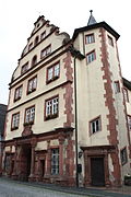
town hall
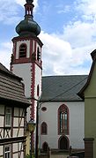
Church of the Assumption

Rothenfels, church, interior view

Rothenfels Castle


Architectural monuments
- Town hall , built 1598/99
Personalities
Born in Rothenfels
- John IV Beck (1516–1562), Cistercian abbot
- Oswald Loschert (1704–1785), Premonstratensian Abbot
- Wilhelm Hepp (1764–1832), organ builder
- Ludwig Lehner (1907–1997), missionary doctor in Manchuria and medical director in Uffenheim
Honorary citizen
- Bruno Uhl (1895–1990)
Web links
- http://www.rothenfels.de/
- http://www.burg-rothenfels.de/
- http://www.burgenwelt.de/rothenfels/gelie.htm
- Entry on the Rothenfels coat of arms in the database of the House of Bavarian History
Individual evidence
- ↑ "Data 2" sheet, Statistical Report A1200C 202041 Population of the municipalities, districts and administrative districts 1st quarter 2020 (population based on the 2011 census) ( help ).
- ↑ http://www.bayerische-landesbibliothek-online.de/orte/ortssuche_action.html ? Anzeige=voll&modus=automat&tempus=+20111119/223504&attr=OBJ&val= 1744
- ↑ Verwaltungsgemeinschaft Marktheidenfeld: Development of the population since 1981 . 2014 ( online [accessed May 9, 2014]). online ( Memento of the original from April 29, 2014 in the Internet Archive ) Info: The archive link was inserted automatically and has not yet been checked. Please check the original and archive link according to the instructions and then remove this notice.
- ↑ a b Wolf-Armin von Reitzenstein : Lexicon of Franconian place names. Origin and meaning . Upper Franconia, Middle Franconia, Lower Franconia. CH Beck, Munich 2009, ISBN 978-3-406-59131-0 , p. 194 ( limited preview in Google Book search).
- ↑ Medieval leprosories in today's Bavaria, Gesellschaft für Leprakunde, Münster 1995, accessed January 5, 2017 ( Memento of the original from February 6, 2015 in the Internet Archive ) Info: The archive link was automatically inserted and not yet checked. Please check the original and archive link according to the instructions and then remove this notice.
- ^ Wilhelm Volkert (ed.): Handbook of Bavarian offices, communities and courts 1799–1980 . CH Beck, Munich 1983, ISBN 3-406-09669-7 , p. 514 .
- ^ Diocese of Würzburg: All deaneries . 2014 ( online [accessed May 9, 2014]).
- ↑ Marktheidenfeld - St. Josef, Bridegroom of Our Lady: Parish Rothenfels . 2014 ( online [accessed May 9, 2014]). online ( Memento of the original from May 4, 2014 in the Internet Archive ) Info: The archive link was inserted automatically and has not yet been checked. Please check the original and archive link according to the instructions and then remove this notice.
- ↑ Marktheidenfeld - St. Josef, Bridegroom of Our Lady: Parish Bergrothenfels . 2014 ( online [accessed June 25, 2014]). online ( Memento of the original from May 4, 2014 in the Internet Archive ) Info: The archive link was inserted automatically and has not yet been checked. Please check the original and archive link according to the instructions and then remove this notice.
- ↑ http://www.main-netz.de/nachrichten/region/lohr/lohr-kurz/art3994,2979286
- ↑ City Council election 2020 , accessed on July 2, 2020

Arnstein | Aura in the reason | Birkenfeld | Bischbrunn | Burgsinn | Erlenbach near Marktheidenfeld | Esselbach | Eußenheim | Skins | Frammersbach | Gemünden am Main | Gössenheim | Graefendorf | Hafenlohr | Hasloch | Sky city | Karbach | Karlstadt | Karsbach | Kreuzwertheim | Lohr am Main | Marktheidenfeld | Middle sense | Neuendorf | Neuhütten | Neustadt am Main | Obersinn | Partenstein | Rechtenbach | Retzstadt | Rieneck | Clearing | Rothenfels | Schollbrunn | Steinfeld | Thüngen | Triefenstein | Urspringen | Wiesthal | Zellingen
Municipality-free areas in the district of Main-Spessart
Burgjoss |
Forest aura |
Forest Lohrerstraße |
Frammersbach Forest |
Princely Löwensteinscher Park |
Haurain |
Herrnwald |
Langenprozeltener forest |
Partenstein Forest |
Ruppertshütten forest