Goessenheim
| coat of arms | Germany map | |
|---|---|---|

|
Coordinates: 50 ° 1 ' N , 9 ° 47' E |
|
| Basic data | ||
| State : | Bavaria | |
| Administrative region : | Lower Franconia | |
| County : | Main-Spessart | |
| Management Community : | Gemünden am Main | |
| Height : | 172 m above sea level NHN | |
| Area : | 11.5 km 2 | |
| Residents: | 1118 (Dec. 31, 2019) | |
| Population density : | 97 inhabitants per km 2 | |
| Postal code : | 97780 | |
| Area code : | 09358 | |
| License plate : | MSP | |
| Community key : | 09 6 77 132 | |
| LOCODE : | DE GO4 | |
| Community structure: | 2 districts | |
| Association administration address: | Frankfurter Strasse 4 a 97737 Gemünden a.Main |
|
| Website : | ||
| Mayor : | Klaus Schäfer (CSU / UGB) | |
| Location of the community of Gössenheim in the Main-Spessart district | ||
Gössenheim is a municipality in the Lower Franconian district of Main-Spessart .
geography
Gössenheim is located on the Wern about 30 kilometers northwest of Würzburg .
Community structure
Gössenheim is divided into two districts:
Surname
etymology
The name Gössenheim consists of the personal name Gozwin and the Old High German word heim .
Earlier spellings
Earlier spellings of the place from various historical maps and documents:
|
|
history
Until the church is planted
Already at the beginning of the 7th century the Main and Wern area was subject to the Merovingian Empire and Franconian settlers had settled here in large numbers. Alemannic, Thuringian, Warnish and Franconian populations mixed in the Werntal.
Historically, the place name Gössenheim 779 was first mentioned. The noble widow Hadaburch donated the Gössenheim area with all its houses and serfs to the Echternach monastery in what is now Luxembourg. Even at the time of Charlemagne, Gössenheim must have been a royal estate and a not insignificant place.
The Homburg (originally "Hohenberg") was built in stone in the middle of the 12th century at the earliest. In 1381 it passed to the von Bickenbach family by succession . In 1469 the place with the Homburg and the surrounding villages were sold to the Hochstift Würzburg, which was part of the Franconian Empire from 1500 .
In the course of the administrative reforms in Bavaria, today's municipality was created with the municipal edict of 1818 .
19th to 21st century
Gössenheim was a fortified village until about 1870, the center of which was surrounded by the ring wall, which is still partially preserved, and secured to the east, north and west. Today, Gössenheim is located on Bundesstrasse 27 between Karlstadt and Hammelburg and is part of the vicinity of the Gemünden sub-center in the Würzburg region.
The landmark of Gössenheim is the mighty castle ruin Homburg . The song festival on the Homburg, which has been taking place on Whit Monday since 1946 and attracts visitors from near and far, is known far beyond the borders of the surrounding area. The wine made from the vines of the new vineyards also bears the name of the castle ruin, namely "Gössenheimer Homburg".
Religions
The political community of Gössenheim is equal in area to the Catholic parish of St. Radegundis Gössenheim of the diocese of Würzburg . In addition to the parish church in Gössenheim with its Gothic tower and the modern nave from 1960, there is the Baroque branch church of St. Hubertus in the Sachsenheim district .
Incorporations
On July 1, 1972, the previously independent town of Sachsenheim was incorporated.
Population development
In the period from 1988 to 2018, the population fell from 1174 to 1140 by 34 inhabitants or 2.9%.
- 1961: 1054 inhabitants
- 1970: 1070 inhabitants
- 1987: 1167 inhabitants
- 1991: 1228 inhabitants
- 1995: 1243 inhabitants
- 2000: 1272 inhabitants
- 2005: 1300 inhabitants
- 2010: 1254 inhabitants
- 2015: 1179 inhabitants
politics
The community is a member of the Gemünden am Main administrative association .
mayor
- since October 17, 2018: Klaus Schäfer (CSU / UGB)
- 2008–2018: Theo Gärtner (independent citizens of Gössenheim)
- 2002–2008: Johann Popp (CSU)
- 1987–2002: Manfred Marold (CSU / Free Voting Community)
coat of arms
|
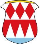
Blazon : “Above a blue shield base divided by silver and red; three red diamonds next to each other at the top, three rising silver tips at the bottom "
Management since 1954. |
|
Tax revenue and debt
In 2017, the municipal tax revenue amounted to € 1,166,000, of which the trade tax revenue (net) was € 352,000 and the income tax participation was € 616,000. The total debt in 2017 was € 196,000, that is € 169 per inhabitant.
Architectural monuments
Economy and Infrastructure
Economy including agriculture and forestry
According to official statistics, there were 234 employees at the place of work in the manufacturing sector and 22 in trade and transport. In other economic areas, 60 people were employed at the place of work subject to social security contributions. There were a total of 316 employees at the place of residence subject to social security contributions. There were two companies in the manufacturing sector and one in the construction sector. In addition, in 2010 there were seven farms with an agriculturally used area of 202 ha, of which 172 ha were arable land and 27 ha were permanent green space.
traffic
Bundesstrasse 27 leads directly through the town . In addition Gössenheim is the frequented almost exclusively by freight trains Wern Valley Railway .
Local heating supply
In 2014, construction work began on the area-wide local heating supply in the area of the municipality of Gössenheim. For this purpose, the Nahwärme Gössenheim eG installed over 8 km of steel pipes, preferably in the public land. The first households were supplied with heat from the Am Energiepark 1 heating center in September 2015, with the final expansion of the approximately nine-kilometer-long local heating network likely to take place in 2016.
education
The following institutions exist as of September 1, 2011:
- Kindergarten: 80 places with 70 children
- Primary school: eight teachers with 100 students
Personalities
- Johann Philipp Seuffert (1693–1780), organ builder
- Gerhard Eichelmann (* 1962) specialist author and publisher for wine
Web links
Individual evidence
- ↑ "Data 2" sheet, Statistical Report A1200C 202041 Population of the municipalities, districts and administrative districts 1st quarter 2020 (population based on the 2011 census) ( help ).
- ↑ http://www.bayerische-landesbibliothek-online.de/orte/ortssuche_action.html ? Anzeige=voll&modus=automat&tempus=+20111119/193935&attr=OBJ&val= 1722
- ↑ a b Wolf-Armin von Reitzenstein : Lexicon of Franconian place names. Origin and meaning . Upper Franconia, Middle Franconia, Lower Franconia. CH Beck, Munich 2009, ISBN 978-3-406-59131-0 , p. 84 ( limited preview in Google Book search).
- ^ Wilhelm Volkert (ed.): Handbook of Bavarian offices, communities and courts 1799–1980 . CH Beck, Munich 1983, ISBN 3-406-09669-7 , p. 470 .
- ^ Entry on the coat of arms of Gössenheim in the database of the House of Bavarian History


