
Administrative community Zellingen
| coat of arms | Germany map | |
|---|---|---|
 Help on coat of arms |
Coordinates: 49 ° 54 ' N , 9 ° 49' E |
|
| Basic data | ||
| State : | Bavaria | |
| Administrative region : | Lower Franconia | |
| County : | Main-Spessart | |
| Area : | 86.55 km 2 | |
| Residents: | 10,834 (Dec 31, 2019) | |
| Population density : | 125 inhabitants per km 2 | |
| License plate : | MSP | |
| Association key : | 09 6 77 5625 | |
| Association structure: | 4 municipalities | |
| Association administration address : |
Würzburger Strasse 26 97225 Zellingen |
|
| Website : | ||
| Chairman : | Wieland Gsell | |
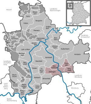
| Location of the administrative community in Zellingen in the Main-Spessart district | ||
  |
||

In the administrative community of Zellingen in the Lower Franconian district of Main-Spessart , the following communities have come together to handle their administrative business:
- Himmelstadt , 1562 inhabitants, 13.42 km²
- Retzstadt , 1565 inhabitants, 18.08 km²
- Thüngen , market , 1334 inhabitants, 13.61 km²
- Zellingen , market , 6373 inhabitants, 41.44 km²
The administrative association is based in Zellingen.
Since May 26, 2008, Dr. Wieland Gsell.
Individual evidence
- ↑ "Data 2" sheet, Statistical Report A1200C 202041 Population of the municipalities, districts and administrative districts 1st quarter 2020 (population based on the 2011 census) ( help ).
Administrative communities in the Main-Spessart district