
Schwandorf district
| coat of arms | Germany map |
|---|---|

|

Coordinates: 49 ° 22 ' N , 12 ° 15' E |
| Basic data | |
| State : | Bavaria |
| Administrative region : | Upper Palatinate |
| Administrative headquarters : | Schwandorf |
| Area : | 1,464.97 km 2 |
| Residents: | 147,872 (Dec. 31, 2019) |
| Population density : | 101 inhabitants per km 2 |
| License plate : | SAD, BUL , NAB , NEN, OVI, ROD |
| Circle key : | 09 3 76 |
| NUTS : | DE239 |
| Circle structure: | 33 municipalities |
| Address of the district administration: |
Wackersdorfer Strasse 80 92421 Schwandorf |
| Website : | |
| District Administrator : | Thomas Ebeling ( CSU ) |
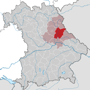
| Location of the district of Schwandorf in Bavaria | |
  |
|
The district of Schwandorf is located in the administrative district of Upper Palatinate in Eastern Bavaria .
geography
location
The district is divided into four natural areas. The north and east belong to the Upper Palatinate Forest , where the Weingartnerfels (896 meters) is the highest elevation in the district, and the south to the Upper Palatinate hill country . In the southeast the foothills of the Bavarian Forest protrude into the district area, in the southwest the foothills of the central Franconian Alb and the Upper Palatinate Jura . The Naab (a left tributary of the Danube ) flows from north to south for about 40 km through the district. To the east of Schwarzenfeld, it takes up the Schwarzach flowing to the west . In the extreme south-east, the Regen river grazes the district for a few kilometers.
Neighboring areas
The district borders counterclockwise in the north, beginning with the districts of Neustadt an der Waldnaab , Amberg-Sulzbach , Neumarkt in der Oberpfalz , Regensburg and Cham . In the northeast it borders on the Czech region of Pilsen .
history
Regional courts
In 1803 the district courts Burglengenfeld, Nabburg and Neunburg vorm Wald were established in today's district . They belonged to the Regenkreis , which was renamed Upper Palatinate and Regensburg (later only Upper Palatinate ) in 1838 . In 1840 another regional court was formed in Oberviechtach.
District Offices
In 1862, the Burglengenfeld district office was created from the Burglengenfeld and Schwandorf district courts, with the Schwandorf district court being newly created from 19 municipalities of the Burglengenfeld district court. Furthermore, the district office Nabburg was formed from the regional court of the same name and the district office Neunburg vorm Wald from the regional courts Neunburg vorm Wald and Oberviechtach. In 1900 a separate district office was established for the Oberviechtach area. In 1920, Schwandorf became a city in the immediate vicinity and left the Burglengenfeld district office. In 1926 the district office Nabburg was changed slightly by integrating three communities from the district office Vohenstrauß, but the district office Nabburg also transferred to the district office Amberg.
Counties
On January 1, 1939, the designation district was introduced as everywhere else in the German Reich . The district offices became Burglengenfeld, Nabburg, Neunburg vorm Wald and Oberviechtach.
In 1940 Schwandorf was incorporated into the Burglengenfeld district, but this was reversed in 1948.

Schwandorf district
As part of the regional reform in Bavaria , a new district was formed on July 1, 1972, the district seat of which was the city of Schwandorf in Bavaria. Became its constituent parts
- until then independent city of Schwandorf in Bavaria, the status of a county for the loss of freedom district town received
- all communities of the dissolved Burglengenfeld district with the exception of nine communities that came to the districts of Amberg-Sulzbach and Regensburg
- all communities of the dissolved district of Nabburg with the exception of the community of Kemnath am Buchberg , which came to the district of Amberg-Sulzbach
- all communities of the dissolved district of Neunburg vorm Wald with the exception of the communities Großenzenried, Hillstett and Pillmersried , which came to the district of Cham
- all communities of the dissolved Oberviechtach district with the exception of the communities Altenschneeberg , Hannesried , Heinrichskirchen , Irlach and Schönau , which came to the Cham district
- the community Wulkersdorf from the district of Regensburg and
- the city of Nittenau and the communities of Bleich, Bruck in the Upper Palatinate , Fischbach and Kaspeltshub of the dissolved district of Roding .
On May 1, 1973, the district received its still valid name, Landkreis Schwandorf, without the addition in Bavaria , since the district town had meanwhile also dropped the addition.
On January 1, 1974, the Wulkersdorf community moved from the Schwandorf district back to the Regensburg district, where it was incorporated into Bernhardswald . On May 1, 1978, the Ponholz community moved from the Regensburg district to the Schwandorf district and was incorporated into Maxhütte-Haidhof .
Population development
From 1988 to 2008 the district of Schwandorf grew by over 12,000 inhabitants or around nine percent. From 2005 to 2012 the population decreased slightly; since then it has risen again and had its previous high of approx. 145,000 inhabitants (2005) as of December 31, 2015.
Between 1988 and 2018 the district grew from 131,283 to 147,189 by 15,906 inhabitants or by 12.1%.
A clear south-west / north-east gradient can be seen in the population development, ie the highest increases are in the Burglengenfeld / Wackersdorf area, the most significant losses near the border in the Schönsee / Oberviechtach area.
The following figures refer to the territorial status on May 25, 1987.
| Population development | ||||||||||||||
|---|---|---|---|---|---|---|---|---|---|---|---|---|---|---|
| year | 1840 | 1900 | 1939 | 1950 | 1961 | 1970 | 1987 | 1991 | 1995 | 2000 | 2005 | 2010 | 2015 | |
| Residents | 65,017 | 74,867 | 89,966 | 121,655 | 123,489 | 135.117 | 131,260 | 136.026 | 139,887 | 143,343 | 144,748 | 142,804 | 144.864 | |
politics
District administrators
- July 1, 1972 to April 30, 1996: Hans Schuierer ( SPD )
- May 1, 1996 to April 30, 2014: Volker Liedtke (SPD)
- since May 1, 2014: Thomas Ebeling ( CSU )
Ebeling is the first district administrator in the Schwandorf district since 1972 who is not a member of the SPD. In the runoff election in 2014, their candidate, Marianne Schieder , a member of the Bundestag , was just inferior to Ebeling.
District council
The local elections in 2002, 2008 , 2014 and 2020 led to the following allocation of seats in the district council:
| 2002 | 2008 | 2014 | 2020 | |
|---|---|---|---|---|
| CSU | 27 | 26th | 24 | 23 |
| SPD | 20th | 18th | 15th | 10 |
| FW | - | - | 8th | 8th |
| GREEN | 2 | 3 | 3 | 5 |
| AfD | - | - | - | 3 |
| ödp | 2 | 2 | 4th | 3 |
| Young voters | 2 | 3 | 3 | 2 |
| CWG SAD | - | - | - | 2 |
| JU | - | - | - | 2 |
| LEFT | - | - | - | 1 |
| FDP | 0 | 1 | - | 1 |
| FWG | 7th | 7th | - | - |
| BWG / UW | - | - | 2 | - |
| BL NBB | - | - | 1 | - |
| total | 60 | 60 | 60 | 60 |
JW, BWG / UW and BL NBB together form a six-person committee. They are the fourth largest group in the district council after FW or before ÖDP and the Greens.
coat of arms
|
|
Blazon : "Split by black and silver, above a lowered, narrow wave bar split by silver and blue, underlaid by a gear split by gold and black, in front a left-facing, red armored and red crowned golden lion , behind a red tin tower." |
Economy and Infrastructure
In the Future Atlas 2016 , the district of Schwandorf was ranked 179 out of 402 districts, municipal associations and independent cities in Germany and is therefore one of the regions with a "balanced risk-opportunity mix" for the future.
traffic
Street
The federal motorway 93 leads through the district of Schwandorf from Hof via Weiden to Regensburg . The important federal highway 85 (also known as the Bayerwaldautobahn in the Bayerwaldautobahn region because of the good upgraded routes between Amberg and Cham ) runs through the district and connects Amberg with Cham . The federal highways 15 , 16 and 22 also run through the district. The A 6 , which connects Nuremberg with Prague, also runs through the northern district.
rail
In the district town of Schwandorf, after Regensburg, the most important railway junction in the Upper Palatinate was built. Two main railways cross here, which were built by the AG der Bayerische Ostbahnen in the previous century.
In 1859 a line ran from Regensburg via Schwandorf to Amberg - Nuremberg. From it branch off:
- 1861 in Schwandorf a train to the east via Bodenwöhr to Furth im Wald and
- 1863 in Irrenlohe the railway in the Naab valley up via Nabburg to Weiden.
More than thirty years later, the Bavarian State Railways began adding four local railways to the route network:
- 1896 from Bodenwöhr Nord to Neunburg vorm Wald and on in 1915 to Rötz
- 1899 from Maxhütte-Haidhof to Burglengenfeld
- (In 1869 there is said to have been a siding to the Maxhütte)
- 1904 from Nabburg to Oberviechtach, which was continued to Schönsee in 1913, and
- 1907 from Bodenwöhr Nord to Nittenau.
Passenger traffic on these branch lines was suspended in the years 1955–1976. The original route network has thus been reduced by 68 km from 157 km to 89 km, in detail:
- 1955: Bodenwöhr North - Bruck - Nittenau 11 km
- 1967: Maxhütte-Haidhof - Burglengenfeld 7 km
- 1969: Bodenwöhr North - Neunburg vorm Wald - Rötz 24 km
- 1976: Nabburg - Oberviechtach - Lind - Schönsee 46 km
Schwandorf station is now the hub for regional trains that are operated by the Oberpfalzbahn of the Länderbahn : In the Naab Valley from Marktredwitz via Weiden to Regensburg and east to Furth and Lam.
Companies
At the district level, the Schwandorf district in the Upper Palatinate is the undisputed first place in terms of tax revenue. The income is even comparable to the districts around Munich . With 130 large industrial companies and 15,000 jobs, the Schwandorf district is the driving force in the region.
Schwandorf's largest employer is currently meiller direct GmbH. Also Benteler is a major employer in the county. The Wackersdorf Innovation Park is located around 50 km north of Regensburg in the middle of the Upper Palatinate Lake District . On the site, which was planned for a nuclear reprocessing plant in the 1980s , today, in addition to BMW AG, nine manufacturing suppliers and three service companies make up the circle of partners at the Wackersdorf Innovation Park with around 2700 employees. A branch of Läpple AG with around 800 employees is based in Teublitz .
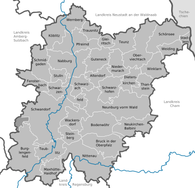
Communities
(Area in km² on December 31, 2001, population as of December 31, 2019)
Other communities
|
|
- Burglengenfelder Forst (?), Was dissolved after 1994
- Bodenwöhrer Forest (4.92 km²) was dissolved on November 1, 2006 and incorporated into the markets of Bruck in the Upper Palatinate and Neukirchen-Balbini and the municipality of Bodenwöhr
- Einsiedler and Walderbacher Forst (18.70 km²) was dissolved on November 1, 2013 and incorporated into the city of Nittenau, the Markt Bruck in the Upper Palatinate and the communities of Reichenbach and Walderbach (both districts of Cham )
- Eastern Neubäuer Forest (15.71 km²) was dissolved on January 1, 2017 and incorporated into the markets of Bruck in the Upper Palatinate and Neukirchen-Balbini as well as the town of Roding and Walderbach (both districts of Cham)
Protected areas
In the district of Schwandorf there are five nature reserves , 17 landscape protection areas , 16 FFH areas and at least 63 geotopes designated by the Bavarian State Office for the Environment (as of August 2016).
See also:
- List of nature reserves in the Schwandorf district
- List of landscape protection areas in the district of Schwandorf
- List of FFH areas in the Schwandorf district
- List of geotopes in the Schwandorf district
License Plate
On July 1, 1956, the independent city of Schwandorf was assigned the distinctive sign SAD when the license plates that are still valid today were introduced . It has been issued for the district since 1972 until today. Since July 10, 2013, the distinctive signs BUL (Burglengenfeld), NAB (Nabburg), NEN (Neunburg vorm Wald), OVI (Oberviechtach) and ROD (Roding) have been available.
Web links
- Official website
- Literature from and about the district of Schwandorf in the catalog of the German National Library
- Entry on the coat of arms of the district of Schwandorf in the database of the House of Bavarian History
Individual evidence
- ↑ "Data 2" sheet, Statistical Report A1200C 202041 Population of the municipalities, districts and administrative districts 1st quarter 2020 (population based on the 2011 census) ( help ).
- ^ Wilhelm Volkert (ed.): Handbook of Bavarian offices, communities and courts 1799–1980 . CH Beck, Munich 1983, ISBN 3-406-09669-7 , p. 97 .
- ^ Ordinance on the reorganization of Bavaria into rural districts and independent cities of December 27, 1971
- ^ Federal Statistical Office (ed.): Historical municipality directory for the Federal Republic of Germany. Name, border and key number changes in municipalities, counties and administrative districts from May 27, 1970 to December 31, 1982 . W. Kohlhammer GmbH, Stuttgart / Mainz 1983, ISBN 3-17-003263-1 , p. 658 .
- ^ Message from the group of voters on Facebook. (accessed on April 29, 2014)
- ^ Entry on the coat of arms of the district of Schwandorf in the database of the House of Bavarian History , accessed on September 5, 2017 .
- ↑ Future Atlas 2016. (No longer available online.) Archived from the original on October 2, 2017 ; accessed on March 23, 2018 . Info: The archive link was inserted automatically and has not yet been checked. Please check the original and archive link according to the instructions and then remove this notice.
- ↑ "Data 2" sheet, Statistical Report A1200C 202041 Population of the municipalities, districts and administrative districts 1st quarter 2020 (population based on the 2011 census) ( help ).
Districts:
Aichach-Friedberg |
Altötting |
Amberg-Sulzbach |
Ansbach |
Aschaffenburg |
Augsburg |
Bad Kissingen |
Bad Toelz-Wolfratshausen |
Bamberg |
Bayreuth |
Berchtesgadener Land |
Cham |
Coburg |
Dachau |
Deggendorf |
Dillingen on the Danube |
Dingolfing-Landau |
Danube Ries |
Ebersberg |
Eichstätt |
Erding |
Erlangen-Höchstadt |
Forchheim |
Freising |
Freyung-Grafenau |
Fürstenfeldbruck |
Fürth |
Garmisch-Partenkirchen |
Gunzburg |
Hatred Mountains |
Yard |
Kelheim |
Kitzingen |
Kronach |
Kulmbach |
Landsberg am Lech |
Landshut |
Lichtenfels |
Lindau (Lake Constance) |
Main-Spessart |
Miesbach |
Miltenberg |
Mühldorf am Inn |
Munich |
Neuburg-Schrobenhausen |
Neumarkt in the Upper Palatinate |
Neustadt an der Aisch-Bad Windsheim |
Neustadt an der Waldnaab |
Neu-Ulm |
Nuremberg Country |
Oberallgäu |
Ostallgäu |
Passau |
Pfaffenhofen an der Ilm |
Rain |
Regensburg |
Rhön-Grabfeld |
Rosenheim |
Roth |
Rottal-Inn |
Schwandorf |
Schweinfurt |
Starnberg |
Straubing Arch |
Tirschenreuth |
Traunstein |
Unterallgäu |
Weilheim-Schongau |
Weißenburg-Gunzenhausen |
Wunsiedel in the Fichtel Mountains |
Wurzburg
Independent cities:
Amberg |
Ansbach |
Aschaffenburg |
Augsburg |
Bamberg |
Bayreuth |
Coburg |
Erlangen |
Fürth |
Hof (Saale) |
Ingolstadt |
Kaufbeuren |
Kempten (Allgäu) |
Landshut |
Memmingen |
Munich |
Nuremberg |
Passau |
Regensburg |
Rosenheim |
Schwabach |
Schweinfurt |
Straubing |
Willows in the Upper Palatinate |
Wurzburg