
Dieterskirchen
| coat of arms | Germany map | |
|---|---|---|

|
Coordinates: 49 ° 25 ' N , 12 ° 25' E |
|
| Basic data | ||
| State : | Bavaria | |
| Administrative region : | Upper Palatinate | |
| County : | Schwandorf | |
| Management Community : | Neunburg vorm Wald | |
| Height : | 499 m above sea level NHN | |
| Area : | 24.13 km 2 | |
| Residents: | 996 (Dec. 31, 2019) | |
| Population density : | 41 inhabitants per km 2 | |
| Postal code : | 92542 | |
| Area code : | 09671 | |
| License plate : | SAD, BUL , NAB , NEN, OVI, ROD | |
| Community key : | 09 3 76 122 | |
| Community structure: | 25 districts | |
| Association administration address: | Kolpingstrasse 3 92431 Neunburg vorm Wald |
|
| Website : | ||
| First Mayor : | Anita Forster | |
| Location of the community Dieterskirchen in the district of Schwandorf | ||
  |
||


Dieterskirchen is a municipality in the district of Schwandorf in the Bavarian administrative district of Upper Palatinate and a member of the administrative community Neunburg vorm Wald .
geography
The community is located in the Oberpfalz-Mitte region between Neunburg vorm Wald and Oberviechtach in the Aschatal .
Neighboring communities
The neighboring communities (clockwise) are: Oberviechtach, Winklarn , Thanstein , Neunburg vorm Wald, Schwarzhofen and Niedermurach .
|
Niedermurach 5 km |
Oberviechtach 6 km |
Winklarn 7 km |
|
Niedermurach 5 km |
.svg)
|
Thanstein 9 km |
|
Schwarzhofen 9 km |
Neunburg vorm Wald 10 km |
Thanstein 9 km |
Community structure
The parish Dieterskirchen has 25 parish parts: The parish village Dieterskirchen. The villages of Bach , Pottenhof , Prackendorf and Weislitz . The hamlets of Stegen and Weichelau . The desert areas of Bruckmühl , Frauenhäusl , Hauserlohhof , Hohenthal , Holzhaus , Katharinenthal , Kieselmühle , Kolmhof , Kuppelhof , Neuhaus , Ödgartenhof , Pottenhofermühle , Saggau , Seugenhof , Silbermühle and Tradhof , the deserts of Wellenthal and Ziegelhütte .
There are the districts of Bach, Dieterskirchen, Prackendorf, Weislitz and Pottenhof.
history
Until the church is planted
Dieterskirchen was first mentioned in a document in 1301 as "Dietholtschirchen". The place belonged to the Electorate of Bavaria and was the seat of a closed Hofmark of the Barons Horneck von Hornberg . In the course of the administrative reforms in Bavaria , the community of Dieterskirchen was created with the community edict of 1818 .
Incorporations
In 1945 or 1946, parts of the dissolved community of Weislitz were incorporated. The previously independent communities of Bach and Prackendorf were incorporated on July 1, 1975 on the occasion of the municipal reform in Bavaria.
Population development
Between 1988 and 2018, the population stagnated or decreased from 1,002 to 999 by 3 inhabitants or 0.3%.
| year | 1840 | 1900 | 1939 | 1950 | 1961 | 1970 | 1987 | 1991 | 1995 | 2000 | 2005 | 2010 | 2015 |
|---|---|---|---|---|---|---|---|---|---|---|---|---|---|
| Residents | 648 | 602 | 635 | 655 | 621 | 653 | 693 | 752 | 749 | 696 | 682 | 646 | 660 |
- 1961: 898 inhabitants
- 1970: 882 inhabitants
- 1987: 995 inhabitants
- 1991: 1071 inhabitants
- 1995: 1079 inhabitants
- 2000: 1086 inhabitants
- 2005: 1061 inhabitants
- 2010: 1015 inhabitants
- 2015: 1011 inhabitants
politics
Administrative community
On May 1, 1976, the municipalities of Dieterskirchen, Neukirchen-Balbini , Thanstein and Schwarzhofen merged to form the administrative community Neunburg vorm Wald .
Municipal council
After the local elections on March 16, 2014 this distribution of seats resulted:
| FW | CSU |
|---|---|
| 3 seats | 9 seats |
Mayoress
Anita Forster has been the first mayor of the Dieterskirchen community since May 2020.
coat of arms
Blazon: In red over a silver mountain of three, inside a red horn, a silver church. Coat of arms since 1978.
Community partnerships
Since 2005 there has been a community partnership with Neufmanil (France).
![]()
Economy and Infrastructure
Economy including agriculture and forestry
According to official statistics, there were 61 employees at the place of work in 1998 in the manufacturing sector; in the area of trade and transport, however, none at all. There were a total of 361 employees at the place of residence subject to social insurance contributions. There were two companies in the manufacturing sector and no companies in the main construction sector. In addition, in 1999 there were 53 farms with an agriculturally used area of 907 ha, of which 606 ha were arable land and 299 ha were permanent green space.
education
There is a kindergarten and the Dieterskirchen elementary school, in which 34 students were taught by two full-time teachers in the 2016/2017 school year.
Culture and sights
- Burgstall Bach
- Dieterskirchen Castle
- Pottenhof Castle
- Volkssternwarte with Planetarium Dieterskirchen
- Catholic parish church of St. Ulrich with a Gothic east choir and nave from the 18th century.
See also: List of architectural monuments in Dieterskirchen and List of ground monuments in Dieterskirchen

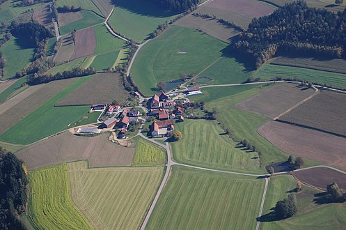
Dieterskirchen (2010)

Parish Church of St. Ulrich
Weislitz (Dieterskirchen)


Individual evidence
- ↑ "Data 2" sheet, Statistical Report A1200C 202041 Population of the municipalities, districts and administrative districts 1st quarter 2020 (population based on the 2011 census) ( help ).
- ↑ Mayor. Dieterskirchen community, accessed June 7, 2020 .
- ^ Community Dieterskirchen in the local database of the Bayerische Landesbibliothek Online . Bavarian State Library, accessed on December 7, 2011.
- ^ Wilhelm Volkert (ed.): Handbook of Bavarian offices, communities and courts 1799–1980 . CH Beck, Munich 1983, ISBN 3-406-09669-7 , p. 535 .
- ^ Federal Statistical Office (ed.): Historical municipality directory for the Federal Republic of Germany. Name, border and key number changes in municipalities, counties and administrative districts from May 27, 1970 to December 31, 1982 . W. Kohlhammer, Stuttgart / Mainz 1983, ISBN 3-17-003263-1 , p. 667 .
- ^ Database statistical data for Bavaria
- ↑ Dieterskirchen community: Dieterskirchen community council. Retrieved March 7, 2017 .
- ^ Entry on the coat of arms of Dieterskirchen in the database of the House of Bavarian History
- ^ Elementary school Dieterskirchen in the school database of the Bavarian State Ministry for Education and Culture , accessed on October 23, 2017.
literature
- Wilhelm Nutzinger: Historical Atlas of Bavaria , Part of Old Bavaria, Issue 52, Neunburg vorm Wald, Munich 1982, ISBN 3-7696-9928-9 .
- Karl-Otto Ambronn: Historical Atlas of Bavaria , Part of Old Bavaria, Series II, Book 3, Landsassen and Landsassengüter of the Principality of the Upper Palatinate in the 16th century, Munich 1982, ISBN 3-7696-9932-7 .
- Emma Mages: Oberviechtach . In: Historical Atlas of Bavaria , part of Old Bavaria . Series I, issue 61. Komm. Für Bayerische Landesgeschichte, Munich 1996, ISBN 3-7696-9693-X ( digitized version ).
- Georg Hager: The art monuments of the Kingdom of Bavaria, Upper Palatinate and Regensburg . Volume II, individual volume 7: District Office Oberviechtach . Munich 1906, reprint ISBN 3-486-50437-1 .
Web links

Altendorf | Bodenwohr | Bruck in the Upper Palatinate | Burglengenfeld | Dieterskirchen | Fensterbach | Slip | Guteneck | Maxhütte-Haidhof | Nabburg | Neukirchen-Balbini | Neunburg vorm Wald | Niedermurach | Nittenau | Oberviechtach | Pfreimd | Schmidgaden | Schönsee | Schwandorf | Schwarzach near Nabburg | Schwarzenfeld | Schwarzhofen | Stadlern | Steinberg am See | Stulln | Teublitz | Teunz | Thanstein | Trausnitz | Wackersdorf | Weiding | Wernberg-Koeblitz | Winklarn
Unregulated areas: Wolferlohe
Bach | Bruckmühl | Dieterskirchen | Frauenhäusl | Hauserlohhof | Hohenthal | Wooden house | Katharinenthal | Pebble mill | Kolmhof | Dome courtyard | Neuhaus | Ödgartenhof | Pottenhof | Pottenhofermühle | Prackendorf | Saggau | Seugenhof | Silver mill | Webs | Tradhof | Weichelau | Weislitz
Desolations: Wellenthal | Brick hut