Neukirchen-Balbini
| coat of arms | Germany map | |
|---|---|---|

|
Coordinates: 49 ° 18 ' N , 12 ° 26' E |
|
| Basic data | ||
| State : | Bavaria | |
| Administrative region : | Upper Palatinate | |
| County : | Schwandorf | |
| Management Community : | Neunburg vorm Wald | |
| Height : | 512 m above sea level NHN | |
| Area : | 47.29 km 2 | |
| Residents: | 1116 (Dec. 31, 2019) | |
| Population density : | 24 inhabitants per km 2 | |
| Postal code : | 92445 | |
| Area code : | 09465 | |
| License plate : | SAD, BUL , NAB , NEN, OVI, ROD | |
| Community key : | 09 3 76 146 | |
| Market structure: | 31 districts | |
| Association administration address: | Kolpingstrasse 3 92431 Neunburg vorm Wald |
|
| Website : | ||
| Mayor : | Markus Dauch ( FWG ) | |
| Location of the Neukirchen-Balbini market in the Schwandorf district | ||
Neukirchen-Balbini is a market in the Upper Palatinate district of Schwandorf and a member of the administrative community Neunburg vorm Wald .
geography
Neukirchen-Balbini is located in the Upper Palatinate Forest Nature Park about ten kilometers southeast of the city of Neunburg vorm Wald and touches the border with the Czech Republic .
Community structure
Neukirchen-Balbini has 31 districts:
- Albenried
- Alletsried
- ground
- Dehnhof
- Egelsried
- Enzenried
- Etzmannsried
- Goppoltsried
- Grottenthal
- Hansenried
- Happassenried
- Haselhof
- Hippoltsried
- Jagenried
- Kitzenried
- Meidenried
- Neualbenried
- Neukirchen-Balbini
- Oberstocksried
- Oedhof
- Rodlseign
- Back yard
- Scheiblhof
- Sperlhof
- Stadlhof
- Unterstocksried
- Weihermühle
- Wirnetsried
- Wolfsgrub
- Brick dump
- Goat mill
history
Until the church is planted
The first place mentioned as "Nuinkhirchen" dates from December 11, 1138 from a document with which Bishop Otto von Bamberg furnished the monastery with several places. In 1297 there is a clerical lord Paldewinus and thus also the parish that gave the place its name as the new churches of Paldewinus . Probably raised to the market before 1300, the place was acquired by the Wittelsbach family on June 19, 1345. Count Palatine Otto equipped the market, whose name changed to Neukirchen-Balbini over the years, with a coat of arms and a seal on November 19, 1449. In the 16th century the subjects had to change their religion four times in 60 years because of religious battles. During the Thirty Years' War , imperial soldiers incinerated the market in 1634, and on March 19, 1641 everything burned down again except for 7 houses. A fire disaster on April 17, 1779, the whole market fell victim, only the church could be saved.
Incorporations
On January 1, 1972, the previously independent municipality of Boden was incorporated with Etzmannsried, Goppoltsried, Grottenthal, Hippoltsried, Oedhof, Rodlseign, Stadlhof and Wirnetsried. On July 1, 1972, the municipality of Egelsried with the districts of Albenried, Haselhof, Jagenried, Neualbenried, Ober- and Unterstocksried and the places Kitzenried and Wolfsgrub from the dissolved municipality of Kleinwinklarn were added. Alletsried with Gebertshof, Happassenried, Meidenried, Rückhof and Sperlhof without Haslarn and Meigelsried and Hansenried without Thanried with Dehnhof, Enzenried, Scheiblhof, Weihermühle and Ziegenmühle followed on May 1, 1978. On January 1, 2017, a part (94 ha ) of the former incorporated in the community-free area of the Eastern Neubäuer Forest .
Population development
Between 1988 and 2018 the population decreased from 1,198 to 1,122 by 76 inhabitants or 6.3%.
politics
- FWG : 12
Administrative community
On May 1, 1976, as part of the regional reform, the formerly independent communities Dieterskirchen , Neukirchen-Balbini, Thanstein and Schwarzhofen merged to form the administrative community Neunburg vorm Wald .
Market Council
The market council consists of twelve members elected in local elections, who have all belonged to the Free Voting Community since the local council election on March 16, 2014 . The turnout was 60.2%.
| FWG |
|---|
| 12 seats |
mayor
The first mayor of the Neukirchen-Balbini market is Markus Dauch (FWG). He was elected in the 2014 local elections with 77.0% of the valid votes.
coat of arms
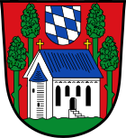
Blazon: In red on green ground between green trees, a towerless, silver church with blue roofs and golden crosses; a sign with the Bavarian diamonds floating above it. The coat of arms was given to Count Palatine Otto I of Mosbach in 1449.
Infrastructure
Neukirchen-Balbini has all the important infrastructure facilities, such as kindergarten, elementary school, library, restaurants and shops for daily needs, as well as a church.
Until 1984 Neukirchen-Balbini had a train station on the Schwandorf – Furth im Wald railway that was far away from the town .
Architectural monuments
Soil monuments
Individual evidence
- ↑ "Data 2" sheet, Statistical Report A1200C 202041 Population of the municipalities, districts and administrative districts 1st quarter 2020 (population based on the 2011 census) ( help ).
- ↑ http://www.bayerische-landesbibliothek-online.de/orte/ortssuche_action.html ? Anzeige=voll&modus=automat&tempus=+20111208/003757&attr=OBJ&val= 1052
- ^ Wilhelm Volkert (ed.): Handbook of Bavarian offices, communities and courts 1799–1980 . CH Beck, Munich 1983, ISBN 3-406-09669-7 , p. 534 .
- ^ Federal Statistical Office (ed.): Historical municipality directory for the Federal Republic of Germany. Name, border and key number changes in municipalities, counties and administrative districts from May 27, 1970 to December 31, 1982 . W. Kohlhammer GmbH, Stuttgart / Mainz 1983, ISBN 3-17-003263-1 , p. 668 and 669 .
- ^ Government of Upper Palatinate: Official Gazette, No. 12, 2016
- ↑ according to source www.wahlen.landkreis-schwandorf.de, accessed on November 25, 2019
Web links
- Entry on the coat of arms of Neukirchen-Balbini in the database of the House of Bavarian History
- The poet Georg Britting tells of the former " Baderhaus ".
- Neukirchen-Balbini: Official statistics of the LfStat


