
Bodenwohr
| coat of arms | Germany map | |
|---|---|---|

|
Coordinates: 49 ° 16 ' N , 12 ° 18' E |
|
| Basic data | ||
| State : | Bavaria | |
| Administrative region : | Upper Palatinate | |
| County : | Schwandorf | |
| Height : | 374 m above sea level NHN | |
| Area : | 54.23 km 2 | |
| Residents: | 4341 (Dec. 31, 2019) | |
| Population density : | 80 inhabitants per km 2 | |
| Postal code : | 92439 | |
| Area code : | 09434 | |
| License plate : | SAD, BUL , NAB , NEN, OVI, ROD | |
| Community key : | 09 3 76 116 | |
| LOCODE : | DE BVR | |
| Community structure: | 16 districts | |
| Address of the municipal administration: |
Schwandorfer Strasse 20 92439 Bodenwöhr |
|
| Website : | ||
| First Mayor : | Georg Hoffmann ( CSU ) | |
| Location of the municipality of Bodenwöhr in the district of Schwandorf | ||
  |
||


Bodenwöhr is a municipality in the southern district of Schwandorf in the Bavarian administrative district of Upper Palatinate . The place is a state-approved resort .
geography
Geographical location
The community is located in the Upper Palatinate in the Upper Bavarian Forest Nature Park on the Schwandorf-Cham railway line. The place is on the Hammersee , created in the 15th century by damming , an eight kilometer long original reservoir for iron smelting. The lake is expanded to the east with the Warbrucker Weiher and to the northwest with the Weichselbrunnweiher. It is fed by the Schafgraben, Gleixnerbach, Reichertweiher Graben, Pechmühlbach, Schwarzenbach and other streams. It drains over the Sulzbach towards Nittenau in the rain .
Community structure
There are 16 officially named municipal parts:
history
Until the church is planted
The place was first mentioned in 1123 as "Potenwre". Before 1464 an iron hammer was moved to Bodenwöhr. With the establishment of the political communities in Bavaria in 1818, the place belonged to the community Neuenschwand.
Church building
In 1820/21 the Neuenschwand community was established with 20 families. The community of Neuenschwand included the village of Kaltenbrunn with seven families and the hamlet of Bodenwöhr with two families. By resolution of August 17, 1818, the Bodenwöhr community was formed from the Bodenwöhr and Blechhammer communities. Since only two subjects were resident in Bodenwöhr in 1818 (the landlord Peter Götz and the beer brewer Georg Faltermeier), the planned formation of the community made little sense. Bodenwöhr was assigned to the Altenschwand community. For reasons unknown, this assignment was not followed. So Bodenwöhr came to the Neuenschwand community. In 1858 the community of Neuenschwand fought unsuccessfully against the incorporation of the village of Blechhammer. In 1859 Bodenwöhr and Blechhamer were released to form their own community. In 1867 the community of Bodenwöhr was to be founded with a tin hammer. However, this would have meant that Neuenschwand would have been too small to continue to exist as a community. In 1879 the government of the Upper Palatinate supported the Bodenwöhrer plan for independence, since "the population elements of this community ... are very different depending on their occupation". While Neuenschwand was predominantly agricultural, there were more industrial workers, traders and civil servants in Bodenwöhr. Until 1921, Bodenwöhr belonged to the independent community of Neuenschwand. In 1921 the name "Neuenschwand Municipality" was changed to "Bodenwöhr Municipality".
Incorporations
On January 1, 1972, the previously independent municipality Taxöldern was incorporated. On May 1, 1978, the former municipality of Erzhäuser and parts of the area of the dissolved municipality of Altenschwand were added.
Population development
Between 1988 and 2018 the community grew by 792 from 3511 to 4303 inhabitants or by 22.6%.
coat of arms
|
|
Blazon : "A golden mallet and a golden hammer crossed diagonally in blue over a silver wave bar."
It thus points to the steelworks that were built in the 15th century. |
Attractions
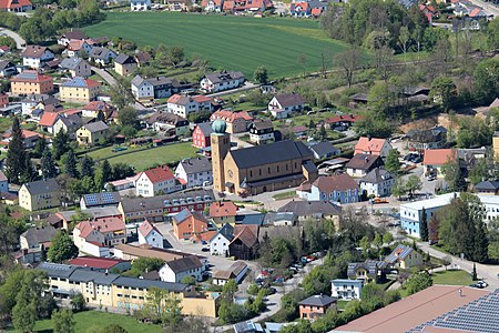
- Parish Church of St. Barbara : It was built from 1948 to 1950 according to the plans of the government master builder Hans Beckers . The style of the church is based on the type of Romanesque basilica . The sandstone from the Erzhäuser district of Bodenwöhr was used as building material .
- Franziskus-Marterl : The Franziskus-Marterl is a WAA resistance memorial in the southeast of the unfinished Wackersdorf reprocessing plant (WAA) in the Altenschwand district .
- Altenschwand Castle
- Taxöldern Castle
- Bodenwohr Castle
nature
- The nature reserve Weichselbrunner Weiher and dry pine forest near Bodenwöhr
- The forest and heathland nature reserve east of Bodenwöhr and Bruck id OPf.
- The Pfahl nature reserve
South of Pingarten is the former quarry in the Pingarten porphyry . The abandoned quarry is one of the 100 most beautiful geotopes in Bavaria.
tourism
Today the Hammersee is rich in fish and offers opportunities for fishing, swimming and sailing with boats without a motor. Three campsites are located directly on the lake (34 hectares of water, 8 kilometers long). There are various public and secluded swimming areas on the lake.
Bodenwöhr has numerous holiday apartments, guest houses, restaurants and hotels, some in the immediate vicinity of the lake, some in the districts.
The well-developed Regen-Schwarzach cycle path (Nittenau-Neunburg) runs along the former Bodenwöhr – Rötz railway line . It is navigable to the north via Neunburg vorm Wald and Kröblitz through the Schwarzach valley to Lake Eixendorfer .
In the surrounding forest and pond landscape, circular and themed hiking trails are signposted. The former training area south of the True Brucker pond has become a quiet nature reserve

Hammersee (2013), on the peninsula in the front right a lido landscape will be built in 2018
St. Barbara (2017), on the right in front of the old town hall and war memorial

Blechhammer (2017), left the train station, front right a bathing area


traffic

The Bodenwöhr Nord station in the Blechhammer district is on the Schwandorf – Furth railway line, which opened in January 1861, in the forest . There are good long-distance connections via Schwandorf to Nuremberg, Munich and via Furth im Wald to Prague.
Here the Bodenwöhr – Nittenau railway branches off , on which only freight traffic takes place. The Bodenwöhr – Rötz railway line has been closed and turned into a cycle path. With both lines, the station on the Nuremberg-Prague main line was a busy passenger and goods station, which is why it has a large track field and the platforms are connected by a tunnel. Until 2007, the station was a loading station for the troops stationed in Neunburg vorm Wald.
Web links
Individual evidence
- ↑ "Data 2" sheet, Statistical Report A1200C 202041 Population of the municipalities, districts and administrative districts 1st quarter 2020 (population based on the 2011 census) ( help ).
- ↑ Mayor. Bodenwöhr municipality, accessed on May 31, 2020 .
- ↑ http://www.bayerische-landesbibliothek-online.de/orte/ortssuche_action.html ? Anzeige=voll&modus=automat&tempus=+20111207/224249&attr=OBJ&val= 1043
- ^ Wilhelm Nutzinger, Historical Atlas of Bavaria, Neunburg vorm Wald, p. 419
- ^ Wilhelm Nutzinger, Historical Atlas of Bavaria, Neunburg vorm Wald, p. 425
- ^ Wilhelm Nutzinger, Historical Atlas of Bavaria, Neunburg vorm Wald, p. 427
- ^ Wilhelm Nutzinger, Historical Atlas of Bavaria, Neunburg vorm Wald, p. 427
- ^ Federal Statistical Office (ed.): Historical municipality directory for the Federal Republic of Germany. Name, border and key number changes in municipalities, counties and administrative districts from May 27, 1970 to December 31, 1982 . W. Kohlhammer GmbH, Stuttgart / Mainz 1983, ISBN 3-17-003263-1 , p. 668 .
- ↑ Entry on the coat of arms of Bodenwöhr in the database of the House of Bavarian History

Altendorf | Bodenwohr | Bruck in the Upper Palatinate | Burglengenfeld | Dieterskirchen | Fensterbach | Slip | Guteneck | Maxhütte-Haidhof | Nabburg | Neukirchen-Balbini | Neunburg vorm Wald | Niedermurach | Nittenau | Oberviechtach | Pfreimd | Schmidgaden | Schönsee | Schwandorf | Schwarzach near Nabburg | Schwarzenfeld | Schwarzhofen | Stadlern | Steinberg am See | Stulln | Teublitz | Teunz | Thanstein | Trausnitz | Wackersdorf | Weiding | Wernberg-Koeblitz | Winklarn
Unregulated areas: Wolferlohe
Altenschwand | Altenschwand (train station) | Tin hammer | Bodenwohr | Book | Ore houses | Höcherhof | Kipfenberg | Mappenberg | Neuenschwand | Bad luck mill | Ping garden | Taxöldern | Turesbach | Warmersdorf | Wind corn