
Thanstein
| coat of arms | Germany map | |
|---|---|---|

|
Coordinates: 49 ° 23 ' N , 12 ° 28' E |
|
| Basic data | ||
| State : | Bavaria | |
| Administrative region : | Upper Palatinate | |
| County : | Schwandorf | |
| Management Community : | Neunburg vorm Wald | |
| Height : | 545 m above sea level NHN | |
| Area : | 27.86 km 2 | |
| Residents: | 951 (Dec. 31, 2019) | |
| Population density : | 34 inhabitants per km 2 | |
| Postal code : | 92554 | |
| Area code : | 09676 | |
| License plate : | SAD, BUL , NAB , NEN, OVI, ROD | |
| Community key : | 09 3 76 172 | |
| Community structure: | 16 districts | |
| Association administration address: | Kolpingstrasse 3 92431 Neunburg vorm Wald |
|
| Website : | ||
| Mayor : | Walter Schauer (Christian voter group Kulz) | |
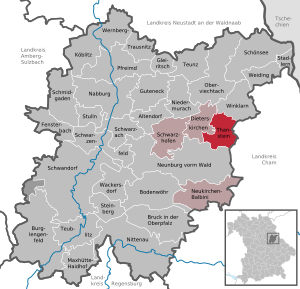
| Location of the municipality of Thanstein in the district of Schwandorf | ||
  |
||


Thanstein is a municipality in the Upper Palatinate district of Schwandorf and a member of the administrative community Neunburg vorm Wald .
geography
Thanstein is located in the Oberpfalz-Mitte region.
Neighboring communities
The neighboring communities (clockwise) are: Winklarn , Rötz , Neunburg vorm Wald and Dieterskirchen .
|
Dieterskirchen 9 km |
Winklarn 8 km |
Winklarn 8 km |
|
Dieterskirchen 9 km |
.svg)
|
Rötz 7 km |
|
Neunburg vorm Wald 10 km |
Neunburg vorm Wald 10 km |
Rötz 7 km |
Community structure
The municipality of Thanstein consists of the parish village of Thanstein and another 15 parts of the municipality:
There are also the deserted Anderlhof, Bayerhof, Reimersäge, Thannmühle and Wagnerhof, which are not officially named parts of the municipality.
There are the districts Berg, Dautersdorf, Kulz and Thanstein.
history
Historically include the castle Old Thanstein , the castle Thanstein and Than flintlock as seats of Hofmark Thanstein (also Tannstein or Tanstein called) closely. The village arose around Thannstein Castle, which was built by the Zenger knightly family .
Thanstein belonged to the Amberg Rent Office and the Neunburg vorm Wald district court of the Electorate of Bavaria . In Thanstein, the Counts of Holnstein owned an open court market. In the course of the administrative reforms in Bavaria , today's municipality was created with the municipal edict of 1818 .
Incorporations
In 1946 the previously independent municipality of Berg was incorporated and on January 1, 1972, the municipality of Dautersdorf was incorporated. On May 1, 1978, the community of Kulz and the districts of Kiesenbeg and Neudeck, which were incorporated in 1946, were added to the dissolved community of Weislitz.
Population development
Between 1988 and 2018 the population decreased from 971 to 962 by 9 inhabitants or 0.9%.
- 1961: 1057 inhabitants
- 1970: 1087 inhabitants
- 1987: 975 inhabitants
- 1991: 968 inhabitants
- 1995: 986 inhabitants
- 2000: 979 inhabitants
- 2005: 1030 inhabitants
- 2010: 992 inhabitants
- 2011: 1003 inhabitants
- 2012: 1000 inhabitants
- 2013: 989 inhabitants
- 2014: 974 inhabitants
- 2015: 970 inhabitants
- 2016: 971 inhabitants
politics
Administrative community
On May 1, 1976, as part of the regional reform, the formerly independent communities Dieterskirchen, Neukirchen-Balbini, Thanstein and Schwarzhofen merged to form the administrative community Neunburg vorm Wald.
Municipal council
The municipal council election on March 16, 2014 resulted in this distribution of seats:
| PWD 1 | FWG 2 | FWU 3 | CWG 4 | CSU |
|---|---|---|---|---|
| 1 seat | 2 seats | 1 seat | 3 seats | 1 seat |
1 Party- free voter group Dautersdorf 2 Free voter group Thanstein 3 Free voter union Kulz 4 Christian voter group Kulz
mayor
Harald Neussinger (FWG Thanstein) was the first mayor from 2008 to 2014. Walter Schauer (Christian voter group Kulz) has been mayor of the Thanstein community since May 2014.
coat of arms
“Through a looped golden tip, inside on a black three-mountain a green fir tree, split by red and black; in front a vertical silver hunting horn, behind a vertical silver pliers ”: coat of arms since 1982.
Culture and sights
- Altenthanstein Castle
- Thanstein Castle
- Thanstein Castle
- Catholic Parish Church of St. John Baptist
Economy and Infrastructure
Economy including agriculture and forestry
In 1998, according to official statistics, there were no employees at the place of work in the manufacturing sector 35 or in the trade and transport sector. There were a total of 288 employees at the place of residence subject to social security contributions. There were three companies in the manufacturing sector and no companies in the main construction sector. In addition, in 1999 there were 89 farms with an agricultural area of 1294 hectares, of which 741 hectares were arable land.
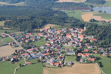
Thanstein (2013)

Castle ruins and church (2013)
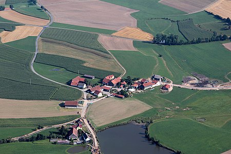
Weihermühle, Tännesried (2013)


Individual evidence
- ↑ "Data 2" sheet, Statistical Report A1200C 202041 Population of the municipalities, districts and administrative districts 1st quarter 2020 (population based on the 2011 census) ( help ).
- ^ Community Thanstein in the local database of the Bavarian State Library Online . Bayerische Staatsbibliothek, accessed on December 12, 2017.
- ^ Wilhelm Volkert (ed.): Handbook of Bavarian offices, communities and courts 1799–1980 . CH Beck, Munich 1983, ISBN 3-406-09669-7 , p. 535 .
- ↑ a b Bavarian State Office for Statistics and Data Processing (Hrsg.): The municipalities of Bavaria according to the territorial status May 25, 1987. The population of the municipalities of Bavaria and the changes in the property and territory from 1840 to 1987 (= contributions to Statistics Bavaria . Issue 451 ). Munich 1991, p. 83–84 , urn : nbn: de: bvb: 12-bsb00070717-7 ( digitized version - footnote 28).
- ^ Federal Statistical Office (ed.): Historical municipality directory for the Federal Republic of Germany. Name, border and key number changes in municipalities, counties and administrative districts from May 27, 1970 to December 31, 1982 . W. Kohlhammer GmbH, Stuttgart / Mainz 1983, ISBN 3-17-003263-1 , p. 668 .
- ^ Municipality of Thanstein: Municipality of Thanstein. Retrieved October 28, 2018 .
- ↑ http://www.wahlen.bayern.de/kommunalwahlen/
literature
- Wilhelm Nutzinger: Historical Atlas of Bavaria, Part of Old Bavaria , Issue 52, Neunburg vorm Wald, Munich 1982, ISBN 3-7696-9928-9
- Elisabeth Müller-Luckner: Historical Atlas of Bavaria, part of Old Bavaria , Issue 50, Nabburg, Munich 1981, ISBN 3-7696-9915-7
- Karl-Otto Ambronn: Historical Atlas of Bavaria, Part Old Bavaria , Series II, Book 3, Landsassen and Landsassengüter of the Principality of the Upper Palatinate in the 16th century, Munich 1982, ISBN 3-7696-9932-7
- Richard Hoffmann, Felix Mader: Art Monuments of the Kingdom of Bavaria, The Art Monuments of Upper Palatinate and Regensburg, District Office Nabburg , Munich 1910.
Web links
- Entry on the coat of arms of Thanstein in the database of the House of Bavarian History
- Thanstein castle ruins, history and structure
- Aerial photos of the place
- Thanstein: Official statistics of the LfStat

Altendorf | Bodenwohr | Bruck in the Upper Palatinate | Burglengenfeld | Dieterskirchen | Fensterbach | Slip | Guteneck | Maxhütte-Haidhof | Nabburg | Neukirchen-Balbini | Neunburg vorm Wald | Niedermurach | Nittenau | Oberviechtach | Pfreimd | Schmidgaden | Schönsee | Schwandorf | Schwarzach near Nabburg | Schwarzenfeld | Schwarzhofen | Stadlern | Steinberg am See | Stulln | Teublitz | Teunz | Thanstein | Trausnitz | Wackersdorf | Weiding | Wernberg-Koeblitz | Winklarn
Unregulated areas: Wolferlohe
Mountain | Dautersdorf | Haindlhof | Hebersdorf | Immerbach | Immerbachermühle | Kiesenberg | Crowyard | Kulz | Kundlmühle | Neudeck | Tännesried | Thanstein | Vormurnthal | Weihermühle | Brick hut